
Peñuelas
Municipio Autónomo de Peñuelas | |
|---|---|
Town and Municipality | |
 Daniel Webster School in Peñuelas | |
 Flag 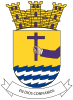 Coat of arms | |
| Nicknames: "La Capital del Güiro" ("The Güiro Capital"), "El Valle de los Flamboyanes" ("The Valley of the Poinciana Trees") | |
| Anthem: "Así es mi pueblo" | |
 Map of Puerto Rico highlighting Peñuelas Municipality | |
| Coordinates: 18°3′34″N 66°43′21″W / 18.05944°N 66.72250°W | |
| Sovereign state | |
| Commonwealth | |
| Founded | 1793 |
| Barrios | |
| Government | |
| • Mayor | Sr. Gregory Gonzalez Souchet (PPD) |
| • Senatorial dist. | 5 - Ponce |
| Area | |
| • Total | 137.42 km2 (53.06 sq mi) |
| • Land | 114 km2 (44 sq mi) |
| • Water | 23.42 km2 (9.04 sq mi) |
| Population (2020)[1] | |
| • Total | 20,399 |
| • Rank | 59th in Puerto Rico |
| • Density | 150/km2 (380/sq mi) |
| • Ethnic groups (2000 Census)[2] | 83.3% European 4.5% African 0.3% Arawak 0.1% Asian 0.1% Native Hawaiian/PI 9.4% Some other ethnicity 2.4% Two or more ethnicities |
| Demonym | Peñolanos |
| Time zone | UTC−4 (AST) |
| ZIP Code | 00624 |
| Area code | 787/939 |
| Major routes | |
| Website | www |
Peñuelas (Spanish pronunciation: [peˈɲwelas], locally [peˈɲwelaʔ]) is a town and municipality in Puerto Rico located in the Peñuelas Valley on the southern coast of the island, south of Adjuntas, east of Guayanilla, west of Ponce and north of the Caribbean Sea. Peñuelas is spread over 12 barrios and Peñuelas Pueblo (the downtown area and the administrative center of the city). It is part of the Yauco Metropolitan Statistical Area. Peñuelas is known as "La Capital del Güiro" (The Güiro Capital) and "El Valle de los Flamboyanes" (The Valley of the Royal Poinciana trees). In 2020, Peñuelas had a population of 20,399.
YouTube Encyclopedic
-
1/1Views:216 610
-
El "VOLCAN" de Peñuelas Documental
Transcription
History
In 1754, a group of workers had settled over the Bay of Tallaboa. Later gradually retreated deeper into the valley, heading tobarrios the most fertile land which would then be part of the town of Peñuelas. For the year 1788, approximately 80 families inhabiting the valley, which focused mainly on agriculture and livestock. Peñuelas Township was founded August 25, 1793 by Diego de Alvarado.[3]
By 1874, the town had been developed and had a population of 9,206, according to a census of that year. The town had four main roads, some streets, a brick church and the town hall, which also served as a prison, barracks and a cemetery.
On March 1, 1902 the Legislative Assembly of Puerto Rico approved a law to consolidate certain municipal districts, so Peñuelas neighborhoods were attached to the municipality of Ponce. In 1905, the same Assembly repealed the law and Peñuelas became once again a municipality.
The first incident of the Puerto Rican Nationalist Party Revolt of 1950 occurred during the early hours of October 29, 1950 in Peñuelas when the insular police of that town surrounded the house of the mother of Melitón Muñiz Santos, the president of the Peñuelas chapter of the Nationalist Party in the barrio Macaná, under the pretext that he was storing weapons for the Nationalist Revolt. Without warning, the police fired upon the Nationalists in the house and a firefight between both factions ensued, which resulted in the death of two Nationalists and the wounding of six police officers.[4] Nationalists Melitón Muñiz Santos, Roberto Jaume Rodríguez, Estanislao Lugo Santiago, Marcelino Turell, William Gutiérrez and Marcelino Berríos were arrested and accused of participating in an ambush against the local insular police.[5]
On September 20, 2017 Hurricane Maria struck the island of Puerto Rico. In Peñuelas, an estimated 1,500 homes were completely destroyed and 500 were partially destroyed.[6] With its winds and rainfall, the hurricane triggered numerous landslides in northern Peñuelas.[7][8]
Geography
Peñuelas is located on the southern coast, slightly west of the center.[9]
Rivers near Peñuelas include:
- Río Guayanés
- Río Macaná
- Río Tallaboa

Barrios

Like all municipalities of Puerto Rico, Peñuelas is subdivided into barrios. The municipal buildings, central square and large Catholic church are located in a barrio referred to as "el pueblo".[10][11][12][13]
Within barrios are communities: For example, the Santo Domingo comunidad ('community') in Santo Domingo barrio and the Tallaboa community in the barrio of Encarnación.
Sectors
Barrios (which are, in contemporary times, roughly comparable to minor civil divisions)[14] and subbarrios,[15] are further subdivided into smaller areas called sectores (sectors in English). The types of sectores may vary, from normally sector to urbanización to reparto to barriada to residencial, among others.[16][17][18]
Special Communities
Comunidades Especiales de Puerto Rico (Special Communities of Puerto Rico) are marginalized communities whose citizens are experiencing a certain amount of social exclusion. A map shows these communities occur in nearly every municipality of the commonwealth. Of the 742 places that were on the list in 2014, the following barrios, communities, sectors, or neighborhoods were in Peñuelas: Maldonado neighborhood (Los Chinos), Santo Domingo barrio, Comunidad Caracoles, and Comunidad La Moca in Tallaboa Alta.[19]
Demographics
Puerto Rico was ceded by Spain in the aftermath of the Spanish–American War under the terms of the Treaty of Paris of 1898 and became a territory of the United States. In 1899, the United States conducted its first census of Puerto Rico finding that the population of Peñuelas was 12,129.
| Census | Pop. | Note | %± |
|---|---|---|---|
| 1900 | 12,129 | — | |
| 1910 | 11,991 | −1.1% | |
| 1920 | 13,598 | 13.4% | |
| 1930 | 13,278 | −2.4% | |
| 1940 | 14,789 | 11.4% | |
| 1950 | 14,931 | 1.0% | |
| 1960 | 14,887 | −0.3% | |
| 1970 | 15,973 | 7.3% | |
| 1980 | 19,116 | 19.7% | |
| 1990 | 22,515 | 17.8% | |
| 2000 | 26,719 | 18.7% | |
| 2010 | 24,282 | −9.1% | |
| 2020 | 20,399 | −16.0% | |
| U.S. Decennial Census[20] 1899 (shown as 1900)[21] 1910-1930[22] 1930-1950[23] 1960-2000[24] 2010[12] 2020[25] | |||
Tourism
Landmarks and places of interest
There are 15 beaches in Peñuelas.[27] The main attractions in Peñuelas are:
- Charco La Soplaera (a natural water pool)
- El Convento Cave
- Don Angel Pacheco Monument
- Guilarte Forest
- Unknown Soldier's Monument
- Parque de Bombas (the old firehouse)
- La Negra Cocola is an 0-4-2T Baldwin Steam Locomotive on display in the main town square
- Peñuelas Museum of Art and History
- Cancha Carlos Rentas Gallardo (Quebrada Ceiba)
Economy
Industry
Manufacturing, refinery.
Government
Like all municipalities in Puerto Rico, Peñuelas is administered by a mayor. The current mayor is Gregory Gonsález Souchet, from the Popular Democratic Party (PPD). Gonsález was elected at a special election in 2018 after the incumbent Walter Torres Maldonado stepped down from the mayoral position.
The city belongs to the Puerto Rico Senatorial district V, which is represented by two Senators. In 2012, Ramón Ruiz and Martín Vargas Morales, from the Popular Democratic Party, were elected as District Senators.[28]
Symbols
The municipio has an official flag and coat of arms.[29]
Flag
It has a rectangular bottom in canary yellow and stands for the sun, symbol of the physical life. In the center it has a purple or violet cross: symbol of Christianity and its ecclesiastical order; it represents the spiritual life. The cross purple extends to all the points of the yellow rectangle.[30]
Coat of arms
The adornment above the shield, a stone wall, represents the perpetuity. The cross represents Santo Cristo de la Salud that "stopped the sea from flooding Peñuelas". The purple arm represents the priesthood and the town of Peñuelas. The canary yellow represents the sun. The blue and white symbolize the choppy sea and the regal ensign represents the faith in Christianity, "In God We Trust".[30]
Culture
Festivals and events
Peñuelas celebrates its patron saint festival in late October / early November. The Fiestas Patronales de San Jose is a religious and cultural celebration that generally features parades, games, artisans, amusement rides, regional food, and live entertainment.[31]
Other festivals and events celebrated in Peñuelas include:[9]
- Endless Fun Festival – April
- Festival of the Cross – May
- National Güiro Festival – May
- Festival of the Flamboyan Tree – Summer
- Children's Festival – August
- Folk Festival – October
- The Cantatas – December
Sports
Peñuelas AA Amateur Baseball team is called Los Petroleros de Peñuelas (The Peñuelas' Oilers.) The origin of this name dates back to the days when Peñuelas was home to a major petro-chemical complex known as CORCO. Although CORCO closed operations in 1980, the name stuck throughout the years.
Also known as Luis "Tite" Arroyo's hometown, a baseball hero. Another hometown hero is Ivelisse Echevarria, who was inducted into the International Federation Softball Hall of Fame in 2003 and is considered by many to be the greatest softball pitcher born in Puerto Rico. Myrian "Betty" Segarra, who was inducted into the International Federation Softball Hall of Fame in 2003 and the best first base in the woman softball in Puerto Rico.
Transportation
Peñuelas' public bus service ("la guagua") connects passengers to Ponce city (east) and Guayanilla (west).
There are 24 bridges in Peñuelas.[32]
Education
6 Elementary schools, 4 Intermediate Schools, 1 High School
See also
References
- ^ Bureau, US Census. "PUERTO RICO: 2020 Census". The United States Census Bureau. Retrieved August 25, 2021.
- ^ "Demographics/Ethnic U.S 2000 census" (PDF). Archived (PDF) from the original on February 16, 2008. Retrieved May 30, 2008.
- ^ "La Historia de Puerto Rico a través de sus Barrios: Barrio Tallaboa de Peñuelas [The History of Puerto Rico through its Barrios: Tallaboa Barrio of Peñuelas]" (video). www.pbslearningmedia.org (in Spanish). Fundación Puertorriqueña de las Humanidades. Retrieved August 29, 2020.
- ^ El ataque Nacionalista s La Fortaleza. by Pedro Aponte Vázquez. Page 7. Publicaciones RENÉ. ISBN 978-1-931702-01-0
- ^ Nationalist Party of Puerto Rico-FBI files
- ^ "María, un nombre que no vamos a olvidar. María revuelca a Peñuelas y se lleva unas 1,500 casas" [Maria, a name we will never forget. Maria rolls through Peñuelas and takes some 1,500 homes]. El Nuevo Día (in Spanish). June 13, 2019. Retrieved September 11, 2022.
- ^ "Preliminary Locations of Landslide Impacts from Hurricane Maria, Puerto Rico". USGS Landslide Hazards Program. USGS. Archived from the original on March 3, 2019. Retrieved March 3, 2019.
- ^ "Preliminary Locations of Landslide Impacts from Hurricane Maria, Puerto Rico" (PDF). USGS Landslide Hazards Program. USGS. Archived (PDF) from the original on March 3, 2019. Retrieved March 3, 2019.
- ^ a b "Peñuelas Municipality". enciclopediapr.org. Fundación Puertorriqueña de las Humanidades (FPH). Archived from the original on August 28, 2019. Retrieved March 20, 2019.
- ^ Picó, Rafael; Buitrago de Santiago, Zayda; Berrios, Hector H. Nueva geografía de Puerto Rico: física, económica, y social, por Rafael Picó. Con la colaboración de Zayda Buitrago de Santiago y Héctor H. Berrios. San Juan Editorial Universitaria, Universidad de Puerto Rico,1969. Archived from the original on December 26, 2018. Retrieved January 13, 2019.
- ^ Gwillim Law (May 20, 2015). Administrative Subdivisions of Countries: A Comprehensive World Reference, 1900 through 1998. McFarland. p. 300. ISBN 978-1-4766-0447-3. Retrieved December 25, 2018.
- ^ a b Puerto Rico:2010:population and housing unit counts.pdf (PDF). U.S. Dept. of Commerce Economics and Statistics Administration U.S. Census Bureau. 2010. Archived (PDF) from the original on February 20, 2017. Retrieved December 26, 2018.
- ^ "Map of Peñuelas at the Wayback Machine" (PDF). Archived from the original (PDF) on March 24, 2018. Retrieved December 29, 2018.
- ^ "US Census Barrio-Pueblo definition". factfinder.com. US Census. Archived from the original on May 13, 2017. Retrieved January 5, 2019.
- ^ "P.L. 94-171 VTD/SLD Reference Map (2010 Census): Peñuelas Municipio, PR" (PDF). www2.census.gov. U.S. DEPARTMENT OF COMMERCE Economics and Statistics Administration U.S. Census Bureau. Archived (PDF) from the original on August 22, 2020. Retrieved August 22, 2020.
- ^ "Agencia: Oficina del Coordinador General para el Financiamiento Socioeconómico y la Autogestión (Proposed 2016 Budget)". Puerto Rico Budgets (in Spanish). Archived from the original on June 28, 2019. Retrieved June 28, 2019.
- ^ Rivera Quintero, Marcia (2014), El vuelo de la esperanza: Proyecto de las Comunidades Especiales Puerto Rico, 1997-2004 (first ed.), San Juan, Puerto Rico Fundación Sila M. Calderón, ISBN 978-0-9820806-1-0
- ^ "Leyes del 2001". Lex Juris Puerto Rico (in Spanish). Archived from the original on September 14, 2018. Retrieved June 24, 2020.
- ^ Rivera Quintero, Marcia (2014), El vuelo de la esperanza:Proyecto de las Comunidades Especiales Puerto Rico, 1997-2004 (Primera edición ed.), San Juan, Puerto Rico Fundación Sila M. Calderón, p. 273, ISBN 978-0-9820806-1-0
- ^ "U.S. Decennial Census". United States Census Bureau. Archived from the original on April 26, 2015. Retrieved September 21, 2017.
- ^ "Report of the Census of Porto Rico 1899". War Department Office Director Census of Porto Rico. Archived from the original on July 16, 2017. Retrieved September 21, 2017.
- ^ "Table 3-Population of Municipalities: 1930 1920 and 1910" (PDF). United States Census Bureau. Archived (PDF) from the original on August 17, 2017. Retrieved September 21, 2017.
- ^ "Table 4-Area and Population of Municipalities Urban and Rural: 1930 to 1950" (PDF). United States Census Bureau. Archived (PDF) from the original on August 30, 2015. Retrieved September 21, 2014.
- ^ "Table 2 Population and Housing Units: 1960 to 2000" (PDF). United States Census Bureau. Archived (PDF) from the original on July 24, 2017. Retrieved September 21, 2017.
- ^ Bureau, US Census. "PUERTO RICO: 2020 Census". The United States Census Bureau. Retrieved August 25, 2021.
- ^ "Population and Housing Unit Estimates". United States Census Bureau. Archived from the original on December 27, 1996. Retrieved September 21, 2017.
- ^ "Las 1,200 playas de Puerto Rico [The 1200 beaches of Puerto Rico]". Primera Hora (in Spanish). April 14, 2017. Archived from the original on December 12, 2019. Retrieved December 12, 2019.
- ^ Elecciones Generales 2012: Escrutinio General Archived 2013-01-15 at the Wayback Machine on CEEPUR
- ^ "Ley Núm. 70 de 2006 -Ley para disponer la oficialidad de la bandera y el escudo de los setenta y ocho (78) municipios". LexJuris de Puerto Rico (in Spanish). Retrieved June 15, 2021.
- ^ a b "PENUELAS". LexJuris (Leyes y Jurisprudencia) de Puerto Rico (in Spanish). February 19, 2020. Archived from the original on February 19, 2020. Retrieved September 17, 2020.
- ^ Torres Guzmán, Sandra (October 29, 2014). "Peñuelas: Regresan las fiestas patronales". La Perla del Sur (in Spanish). Archived from the original on July 18, 2020. Retrieved July 18, 2020.
- ^ "Peñuelas Bridges". National Bridge Inventory Data. US Dept. of Transportation. Archived from the original on February 22, 2019. Retrieved February 20, 2019.
External links
Places adjacent to Peñuelas, Puerto Rico | ||||||||||||||||
|---|---|---|---|---|---|---|---|---|---|---|---|---|---|---|---|---|
| ||||||||||||||||
| International | |
|---|---|
| National | |