
Paso de los Toros | |
|---|---|
City | |
 Monument in El Toro Square | |
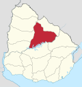
 Paso de los Toros Location in Uruguay | |
| Coordinates: 32°49′05″S 56°30′23″W / 32.81806°S 56.50639°W | |
| Country | |
| Department | Tacuarembó |
| Population (2011 Census) | |
| • Total | 12,985 |
| • Demonym | isabelino |
| Time zone | UTC -3 |
| Postal code | 45100 |
| Dial plan | +598 4664 (+4 digits) |
| Website | municipiopasodelostoros.gub.uy |
Paso de los Toros (Bulls' Pass) is a city of the Tacuarembó Department in Uruguay.
History
The Midland Uruguay Railway began operation in 1889 with a line that ran between Paso de los Toros and Salto.[1] On 17 July 1903, the group of houses of the area known as Paso de los Toros was declared a "Pueblo" (village) named "Santa Isabel" and became head of the judicial section of the same name. On 27 November 1929 it was renamed to "Paso de los Toros" and its status was elevated to "Villa" (town) by the Act of Ley Nº 8.523.[2] On 1 July 1953, its status was further elevated to "Ciudad" (city) by the Act of Ley Nº 11.952.[3]
Population
In 2011, Paso de los Toros had a population of 12,985,[4] which makes it the second largest city in the department, after the capital city of Tacuarembó.
| Year | Population |
|---|---|
| 1908 | 4,963 |
| 1963 | 11,359 |
| 1975 | 13,032 |
| 1985 | 13,026 |
| 1996 | 13,315 |
| 2004 | 13,231 |
| 2011 | 12,985 |
Source: Instituto Nacional de Estadística de Uruguay[2]
Geography
The city is located on the north bank of Río Negro and on Route 5, about 140 kilometres (87 mi) south-southwest of Tacuarembó, the capital of the department, and about 66 kilometres (41 mi) north of Durazno, the capital of Durazno Department.
Climate
| Climate data for Paso de los Toros (1980–2009) | |||||||||||||
|---|---|---|---|---|---|---|---|---|---|---|---|---|---|
| Month | Jan | Feb | Mar | Apr | May | Jun | Jul | Aug | Sep | Oct | Nov | Dec | Year |
| Record high °C (°F) | 42.8 (109.0) |
41.0 (105.8) |
38.6 (101.5) |
36.0 (96.8) |
32.3 (90.1) |
28.8 (83.8) |
30.3 (86.5) |
33.2 (91.8) |
35.5 (95.9) |
36.0 (96.8) |
39.5 (103.1) |
40.9 (105.6) |
42.8 (109.0) |
| Mean daily maximum °C (°F) | 31.1 (88.0) |
29.5 (85.1) |
27.8 (82.0) |
23.6 (74.5) |
19.7 (67.5) |
16.6 (61.9) |
16.2 (61.2) |
18.4 (65.1) |
19.9 (67.8) |
23.3 (73.9) |
26.3 (79.3) |
29.3 (84.7) |
23.5 (74.3) |
| Daily mean °C (°F) | 24.9 (76.8) |
23.9 (75.0) |
22.4 (72.3) |
18.5 (65.3) |
14.8 (58.6) |
12.0 (53.6) |
11.5 (52.7) |
13.1 (55.6) |
14.6 (58.3) |
17.8 (64.0) |
20.5 (68.9) |
23.1 (73.6) |
18.1 (64.6) |
| Mean daily minimum °C (°F) | 18.7 (65.7) |
18.3 (64.9) |
16.9 (62.4) |
13.5 (56.3) |
10.0 (50.0) |
7.4 (45.3) |
6.7 (44.1) |
7.9 (46.2) |
9.3 (48.7) |
12.3 (54.1) |
14.6 (58.3) |
17.0 (62.6) |
12.7 (54.9) |
| Record low °C (°F) | 7.6 (45.7) |
4.0 (39.2) |
4.6 (40.3) |
1.4 (34.5) |
−1.7 (28.9) |
−5.0 (23.0) |
−5.0 (23.0) |
−3.3 (26.1) |
−1.6 (29.1) |
0.4 (32.7) |
3.2 (37.8) |
6.3 (43.3) |
−5.0 (23.0) |
| Average precipitation mm (inches) | 108.1 (4.26) |
127.5 (5.02) |
114.7 (4.52) |
156.3 (6.15) |
119.4 (4.70) |
99.3 (3.91) |
88.4 (3.48) |
77.3 (3.04) |
95.3 (3.75) |
117.7 (4.63) |
111.6 (4.39) |
105.9 (4.17) |
1,321.7 (52.04) |
| Average precipitation days (≥ 1.0 mm) | 6 | 7 | 6 | 6 | 6 | 6 | 7 | 6 | 6 | 7 | 6 | 6 | 75 |
| Average relative humidity (%) | 63 | 68 | 71 | 75 | 79 | 81 | 79 | 76 | 73 | 71 | 67 | 63 | 72 |
| Mean monthly sunshine hours | 282.1 | 228.8 | 229.4 | 186.0 | 170.5 | 135.0 | 155.0 | 179.8 | 192.0 | 220.1 | 255.0 | 285.2 | 2,518.9 |
| Mean daily sunshine hours | 9.3 | 8.1 | 7.4 | 6.2 | 5.5 | 4.5 | 5.0 | 5.8 | 6.4 | 7.1 | 8.5 | 9.2 | 6.9 |
| Source 1: Instituto Nacional de Investigación Agropecuaria[5] | |||||||||||||
| Source 2: Dirección Nacional de Meteorología (precipitation days 1961–1990, extremes 1937–1994)[6][7] | |||||||||||||
Places of worship
Soft drink
In Uruguay, Pepsi manufactures a Paso de los Toros soft drink named after the city.
Noted local people
- Fabián O'Neill: football player
- Jairo O'Neil: football player
- Mario Benedetti: writer
- Nelson Acosta: football manager
- Víctor Púa: football manager
- Waldemar Rial: basketball player
References
- ^ "AFE / Historia / Las Companias". Administración de Ferrocarriles del Estado (AFE). Archived from the original on 19 October 2013. Retrieved 6 September 2012.
- ^ a b "Statistics of urban localities (1908–2004) (see also "Santa Isabel")" (PDF). INE. 2012. Retrieved 6 September 2012.
- ^ "LEY N° 11.952". República Oriental del Uruguay, Poder Legislativo. 1953. Archived from the original on 10 June 2015. Retrieved 6 September 2012.
- ^ "Censos 2011 Cuadros Tacuarembó". INE. 2012. Retrieved 25 August 2012.
- ^ Castaño, José; Giménez, Agustín; Ceroni, Mauricio; Furest, José; Aunchayna, Rossina. "Caracterización Agroclimática del Uruguay 1980–2009" (PDF) (in Spanish). Instituto Nacional de Investigación Agropecuaria. Archived from the original (PDF) on 12 December 2018. Retrieved 15 December 2018.
- ^ "Estadísticas climatológicas" (in Spanish). Dirección Nacional de Meteorología. Retrieved 28 September 2016.
- ^ "RECORDS METEOROLOGICOS EN EL URUGUAY" (in Spanish). Dirección Nacional de Meteorología. Retrieved 28 September 2016.
External links
Capital: Tacuarembó | ||
| Municipalities |
|  |
| Towns and villages | ||
| Sights | ||
| International | |
|---|---|
| National | |
| Other | |
This article about a place in Tacuarembó Department is a stub. You can help Wikipedia by expanding it. |