
| Groton | |
|---|---|
 St Bartholomew's Church, Groton | |
 Groton Location within Suffolk | |
| Area | 6.239 km2 (2.409 sq mi) |
| Population | 299 (2021 census) |
| • Density | 48/km2 (120/sq mi) |
| Civil parish |
|
| District | |
| Shire county | |
| Region | |
| Country | England |
| Sovereign state | United Kingdom |
| Post town | Sudbury |
| Postcode district | CO10 |
| UK Parliament | |

Groton is a village and civil parish in the Babergh district, Suffolk, England, located around a mile north of the A1071 between Hadleigh and Sudbury. In 2021 the parish had a population of 299.[1]
The parish church dedicated to Saint Bartholomew is flint faced and has some 15th-century features; it was heavily restored in the 19th century. It is a Commonwealth War Grave site. The village has no shops but does have the pub the Fox and Hounds.[2] In addition to Groton village, the parish contains the hamlets of Broad Street, Castling's Heath, Gosling Green, Horner's Green, and Parliament Heath. It is home to several Ancient Woodlands: the Groton Wood SSSI, the Mill Wood and Winding Wood nature reserves, and a section of Bull's Cross Wood (part of the Milden Thicks SSSI). Also found in the parish are a tributary to the River Box and Pitches Mount, the remaining earthworks of a wooden castle.
The parish borders Boxford, Edwardstone, Kersey, Lindsey and Milden.[3] There are 21 listed buildings in Groton.[4]
History
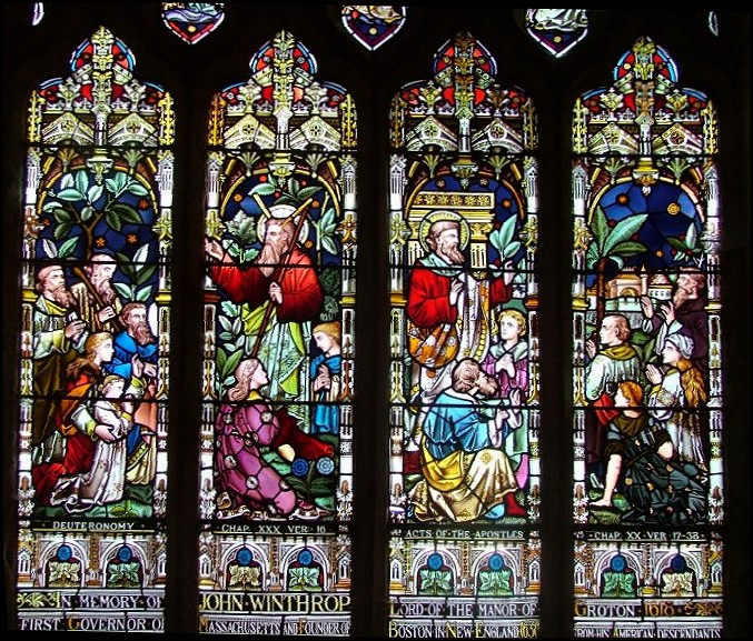
The name "Groton" means 'Sandy or gravelly stream'.[5] In 1086, Groton was listed in the Domesday Book as Grotena[6] in the hundred of Babergh.[7] The lord of the manor was originally the Abbot of Bury St Edmunds but, at the Dissolution, it was granted to the Winthrops.[8] Groton, Massachusetts, is named after the village, as it was founded by a member of the Winthrop family. John Winthrop was born at Groton Manor in 1587; he became the leader of the Winthrop Fleet, a founder of the city of Boston, and one of the first Governors of the Massachusetts Bay Colony. The parish church has a Victorian stained glass window in his memory.[9]
Groton, Connecticut, was also named after the village by Winthrop's son John Winthrop the Younger who settled in that area in 1646. On a common called "The Croft" in the village is an old Mulberry tree said to have been planted by Adam Winthrop, the grandfather of John the elder.[10]
There are other locations named Groton in the United States, which are generally named after the Massachusetts town.
From 1894 until 1974 it was in Cosford Rural District in the administrative county of West Suffolk.[11] In 1974 it became part of Babergh non-metropolitan district in the non-metropolitan county of Suffolk.
Broad Street
Broad Street a hamlet in the parish, it is located near Mill Green. It is also the location of Pytches Mount.
Pitches Mount
In Groton Park, Pitches Mount or Pytches is an example of a Norman motte and bailey castle. It may have been built in the 12th Century by Adam de Cockfield. Only the motte or mound survives, which is 200 feet in diameter and covered in bushes and undergrowth. The name is thought by some to come from the Pecche family, who held Groton for the Abbot of Bury St Edmunds in 1200. It is more likely to be named after John Pytches who bought Groton Great House in 1805.[12]
Castling's Heath
Castling's Heath is a hamlet in the parish. It has a barn called Castling's Hall, which is also called Dove Barn, where weddings take place.[13]
Gosling Green
Gosling Green is a hamlet in the parish, It is just by Groton Wood SSSI.
Location grid
Places adjacent to Groton, Suffolk | ||||||||||||||||
|---|---|---|---|---|---|---|---|---|---|---|---|---|---|---|---|---|
| ||||||||||||||||
Notable residents
- John Winthrop (1587–1649), founder of Boston and second governor of the Massachusetts Bay Colony
- John Winthrop the Younger (1606–1676), governor of the Connecticut Colony.
- Elizabeth Fones (1610–1673), early settler in the Massachusetts Bay Colony and founder of Greenwich, Connecticut.
- Deane Winthrop (1623–1704), Puritan colonist and first settler of Nashoba Valley.
- Lord Frederick Beauclerk (1773-1850), a notable cricketer during the single-wicket era.
- Robert Longden (1817–1895), clergyman and a cricketer.
- Ruth Rendell (1930-2015), award-winning crime writer.
References
- ^ "Groton". City Population. Retrieved 18 January 2024.
- ^ "Suffolk Churches". suffolkchurches.co.uk.
- ^ "Areas touching Groton". Mapit. Retrieved 18 January 2024.
- ^ "Listed buildings in Groton, Babergh, Suffolk". British Listed Buildings. Retrieved 18 January 2024.
- ^ "Groton Key to English Place-names". The University of Nottingham. Retrieved 18 January 2024.
- ^ "The National Archives | DocumentsOnline | Image Details". www.nationalarchives.gov.uk. Archived from the original on 5 June 2011.
- ^ Open Domesday Online: Groton
- ^ "Groton - Gunnerton". british-history.ac.uk.
- ^ http://www.suffolkchurches.co.uk/images/suffolk0604177461.jpg [bare URL image file]
- ^ "Open Writing". openwriting.com.
- ^ "Relationships and changes Groton AP/CP through time". A Vision of Britain through Time. Retrieved 18 January 2024.
- ^ "Heritage Gateway - Results".
- ^ "Dove Barn". weddingvenues.com.
External links
- Pitches Mount Geograph
| International | |
|---|---|
| National | |