
Nawalparasi (West of Bardaghat Susta)
नवलपरासी (बर्दघाट सुस्ता पश्चिम) | |
|---|---|
 | |
| Nickname: नवलपरासी पश्चिम or नवलपरासी (ब.सु.प.) | |
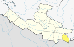 Location of Nawalparasi West (dark yellow) in Lumbini Province | |
 Divisions of Nawalparasi West | |
| Coordinates: 27°19′N 83°24′E / 27.32°N 83.40°E | |
| Country | |
| Province | Lumbini Province |
| Established | 2015 |
| Admin HQ. | Ramgram |
| Government | |
| • Type | Coordination committee |
| • Body | DCC, Parasi |
| Area | |
| • Total | 634.88 km2 (245.13 sq mi) |
| Population | |
| • Total | 321,058 |
| • Density | 510/km2 (1,300/sq mi) |
| Time zone | UTC+05:45 (NPT) |
| Website | dccnawalparasiwest |
Nawalparasi (West of Bardaghat Susta) district or Nawalparasi West, as known commonly (Nepali: नवलपरासी (बर्दघाट सुस्ता पश्चिम) वा नवलपरासी पश्चिम [nʌwʌlpʌˈɾasi ˈpʌst͡sim]), also frequently referred to as just Parasi District, is a district located in Lumbini Province of Nepal. It is 1 out of 12 districts of Lumbini Province. The headquarter of the district is located in Ramgram.[1]
Formerly, Nawalparasi West was a part of Nawalparasi District, the other part being Nawalparasi East (natively called Nawalpur). Thus, the districts Nawalparasi (West of Bardaghat Susta) and Nawalparasi (East of Bardaghat Susta) were created after the state's reconstruction of administrative divisions as of 20 September 2015.
The total area of Nawalparasi District is 634.88 square kilometres (245.13 sq mi) and total population of this district as of 2011 Nepal census is 321058 individuals. Bhojpuri is the local language of the district.[2]
YouTube Encyclopedic
-
1/1Views:470
-
RAMGRAM STUPA !!! #Ramgram stupa #Parasi #wikipedia
Transcription
Demographics
At the time of the 2011 Nepal census, Parasi District had a population of 331,904.
As their first language, 55.7% spoke Bhojpuri, 26.8% Nepali, 8.7% Tharu, 3.3% Maithili, 2.8% Magar, 1.2% Gurung, 0.4% Newar, 0.3% Tamang, 0.1% Bhujel, 0.1% Doteli, 0.1% Hindi, 0.1% Urdu and 0.1% other languages.[3]
Ethnicity/caste: 18.4% were Tharu, 11.5% Hill Brahmin, 7.4% Chamar/Harijan/Ram, 6.9% Musalman, 6.4% Magar, 5.8% Yadav, 4.6% Chhetri, 3.5% Kewat, 3.3% Teli, 2.9% Kami, 2.0% Kahar, 1.9% Gurung, 1.8% Koiri/Kushwaha, 1.7% Dhobi, 1.7% Kurmi, 1.6% Dusadh/Pasawan/Pasi, 1.5% Kathabaniyan, 1.4% Rajbhar, 1.3% other Terai, 1.1% Musahar, 1.1% Newar, 1.0% Damai/Dholi, 0.9% Hajam/Thakur, 0.9% Sanyasi/Dasnami, 0.8% Mallaha, 0.7% Kumal, 0.6% Bin, 0.6% Lohar, 0.6% Thakuri, 0.5% Badhaee, 0.5% Gaderi/Bhedidar, 0.5% Halwai, 0.5% Tamang, 0.4% Kalwar, 0.4% Sarki, 0.3% Terai Brahmin, 0.2% Baraee, 0.2% other Dalit, 0.2% Dhankar/Dharikar, 0.2% Dhunia, 0.2% Khawas, 0.2% Kumhar, 0.2% Rajput, 0.1% Badi, 0.1% Bengali, 0.1% Darai, 0.1% Dom, 0.1% Gharti/Bhujel, 0.1% Kayastha, 0.1% Mali, 0.1% Pattharkatta/Kushwadiya, 0.1% Rai, 0.1% Sonar, 0.1% Yakkha and 0.1% others.[4]
Religion: 88.5% were Hindu, 6.8% Muslim, 3.4% Buddhist, 0.8% Christian, 0.1% Bon, 0.1% Kirati and 0.1% others.[5]
Literacy: 66.6% could read and write, 2.0% could only read and 31.3% could neither read nor write.[6]
Divisions
The district is divided into 7 local level body[7] in which 3 are urban municipality and 4 are rural municipality.[8]
Urban municipality
Rural municipality
- Susta Rural Municipality
- Palhinandan Rural Municipality
- Pratappur Rural Municipality
- Sarawal Rural Municipality
See also
References
- ^ "पूर्वी नवलपरासीको नाम 'नवलपुर जिल्ला' र सदरमुकाम कावासोतीमा राख्ने निर्णय" [Decision to named Nawalpur of the East Nawalparasi and fix Headquarter at Kawasoti]. www.kantipurdaily.com (in Nepali). KMG. 22 September 2017. Archived from the original on 22 March 2018. Retrieved 22 March 2018.
- ^ Gopal Thakur Lohar (2006-06-04). A Sociolinguistic Survey of the Bhojpuri Language in Nepal.
- ^ NepalMap Language [1]
- ^ NepalMap Caste [2]
- ^ NepalMap Religion [3]
- ^ NepalMap Literacy [4]
- ^ "CITY POPULATION– statistics, maps & charts". www.citypopulation.de. 8 October 2017. Retrieved 22 March 2018.
- ^ "District Corrected Last for RAJAPATRA (page no. 261)" (PDF). www.mofald.gov.np. Retrieved 2 March 2018.
External links
Headquarter: Ramgram | ||
| Urban Municipality:3 |  | |
| Rural Municipality:4 | ||
27°19′N 83°24′E / 27.32°N 83.40°E
This article about a location in the Lumbini Province of Nepal is a stub. You can help Wikipedia by expanding it. |