
| Département du Pô | |||||||||
|---|---|---|---|---|---|---|---|---|---|
| department of the First French Republic and of the First French Empire | |||||||||
| 1802–1814 | |||||||||
 Flag | |||||||||
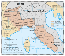 Administrative map of the Italian portion of the French Empire. | |||||||||
| Capital | Turin | ||||||||
| Area | |||||||||
| • Coordinates | 45°04′N 07°42′E / 45.067°N 7.700°E | ||||||||
• 1812[1] | 4,145.26 km2 (1,600.49 sq mi) | ||||||||
| Population | |||||||||
• 1812[1] | 399237 | ||||||||
| History | |||||||||
| 11 September 1802 | |||||||||
| 11 April 1814 | |||||||||
| Political subdivisions | 3 Arrondissements [1] | ||||||||
| |||||||||
Pô (French: [po]) was a department of the French Consulate and of the First French Empire in present-day Italy. It was named after the river Po. It was formed in 1802, when the Subalpine Republic (formerly the mainland portion of the Kingdom of Sardinia) was directly annexed to France. A provisional department called Eridan was planned in 1799 and established in 1801 in the French-occupied Piedmont. After the annexation, Eridan was divided between Po and Doire. Its capital was Turin.
The department was disbanded after the defeat of Napoleon in 1814. At the Congress of Vienna, the Savoyard King of Sardinia was restored in all his previous realms and domains, including Piedmont. Its territory is now part of the Italian province of Turin.
Subdivisions

The department was subdivided into the following arrondissements and cantons (situation in 1812):[1]
- Turin, cantons: Carignano, Carmagnola, Casalborgone, Ceres, Cirié, Corio, Caselle, Gassino, Lanzo, Moncalieri, Orbassano, Poirino, Chieri (French: Quiers), Riva presso Chieri, Rivoli, Turin (6 cantons), Venaria and Viù.
- Pinerolo, cantons: Bricherasio, Cavour, Cumiana, Fenestrelle, None, Perosa, Pinerolo, Torre Pellice, Val Balsiglia, Vigone and Villafranca.
- Susa, cantons: Avigliana, Bardonecchia, Bussoleno, Cesana, Giaveno, Oulx, Susa and Villar Almese.
Its population in 1812 was 399,237, and its area was 414,526 hectares.[1]
Governing Prefects
- 26 August 1802–1805—Victor Hercule Joseph Ferdinand comte de Lavilla de Villasteloni
- 1805–1808—Pierre Loysel
- 1808–1809—Étienne Vincent Marnolia
- 19 February 1809–1813—Alexandre Théodore Victor de Lameth baron de Lameth
References
- ^ a b c d Almanach Impérial an bissextil MDCCCXII, p. 449-450, accessed in Gallica 26 July 2013 (in French)
- ^ "Décret du 24 Fructidor". Archived from the original on 2011-07-19. Retrieved 2010-09-28.
| Ionian Islands | |
|---|---|
| Austrian Netherlands | |
| Old Swiss Confederacy | |
| Kingdom of Holland | |
| Holy Roman Empire | |
| Italian states | |
| Kingdom of Spain | |
| Austrian Empire |
|
This Italian history article is a stub. You can help Wikipedia by expanding it. |
This French history–related article is a stub. You can help Wikipedia by expanding it. |