
Osage Township | |
|---|---|
 | |
| Coordinates: 38°04′04″N 092°43′20″W / 38.06778°N 92.72222°W | |
| Country | United States |
| State | Missouri |
| County | Camden |
| Area | |
| • Total | 26.46 sq mi (68.52 km2) |
| • Land | 20.5 sq mi (53.1 km2) |
| • Water | 5.96 sq mi (15.42 km2) 22.5% |
| Elevation | 705 ft (215 m) |
| Population (2010) | |
| • Total | 4,945 |
| • Density | 186.9/sq mi (72.2/km2) |
| FIPS code | 29-55046[2] |
| GNIS feature ID | 0766392 |
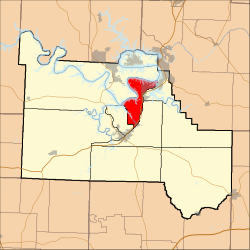
Osage Township is one of eleven townships in Camden County, Missouri, USA. As of the 2010 census, its population was 4,945.
Osage Township was established in 1841, taking its name from the Osage River.[3]
YouTube Encyclopedic
-
1/1Views:42 957
-
It Started Here: Early Arkansas and The Louisiana Purchase
Transcription
Geography
Osage Township borders Jasper Township to the north and west, Pawhuska Township to the east, Kiheka Township to the east, and Osceola Township to the southwest.
Osage Township covers an area of 26.46 square miles (68.5 km2) and contains two incorporated settlements: Linn Creek and Osage Beach. It contains four cemeteries: Hall, Hopkins, Memorial and Old Erie.
The streams of Blue Springs Branch, Linn Creek, North Fork Linn Creek and South Fork Linn Creek run through this township.
Transportation
Osage Township contains two airports or landing strips: Hospital Property Heliport and Linn Creek-Grand Glaize Memorial Airport.
References
- ^ "US Board on Geographic Names". United States Geological Survey. October 25, 2007. Retrieved January 31, 2008.
- ^ "U.S. Census website". United States Census Bureau. Retrieved January 31, 2008.
- ^ "Camden County Place Names, 1928–1945 (archived)". The State Historical Society of Missouri. Archived from the original on June 24, 2016. Retrieved September 8, 2016.
{{cite web}}: CS1 maint: bot: original URL status unknown (link)
External links
Municipalities and communities of Camden County, Missouri, United States | ||
|---|---|---|
| Cities |  | |
| Villages | ||
| Townships | ||
| CDPs | ||
| Other communities | ||
| Footnotes | ‡This populated place also has portions in an adjacent county or counties | |
This Camden County, Missouri state location article is a stub. You can help Wikipedia by expanding it. |