
| Ōreti River New River | |
|---|---|
 Ōreti River near Lumsden | |
 The Ōreti River system | |
| Etymology | Maori meaning "river of canoes" |
| Native name | Ōreti (Māori) |
| Location | |
| Country | New Zealand |
| Region | Southland |
| Cities | Invercargill |
| Physical characteristics | |
| Source | Thomson Mountains |
| • coordinates | 45°9′18″S 168°12′43″E / 45.15500°S 168.21194°E |
| Mouth | New River Estuary |
• location | Foveaux Strait |
• coordinates | 46°28′S 168°17′E / 46.467°S 168.283°E |
• elevation | Sea level |
| Length | 170 kilometres (110 mi) |
| Basin features | |
| Tributaries | |
| • left | Makarewa River, Windley River |
The Ōreti River (formerly the Oreti River) is one of the main rivers of Southland, New Zealand, and is 170 kilometres (110 mi) long. The river has been identified as an Important Bird Area by BirdLife International because, for much of its length, it supports breeding colonies of black-billed gulls.[1][failed verification][2]
The New Zealand Ministry for Culture and Heritage gives a translation of "place of the snare" for Ōreti.[3] In November 2019, the name of the river was officially altered to Ōreti River.[4]
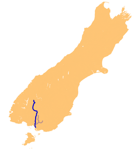
The Ōreti has its headwaters close to the Mavora Lakes between Lake Te Anau and Lake Wakatipu, and flows south across the Southland Plains to its outflow into Foveaux Strait at the southeastern end of Oreti Beach. En route, it runs through the towns of Lumsden and Winton, before passing through the city of Invercargill, close to the river's estuary.
For the final part of the river's length, around the city of Invercargill and the river's estuary just south of the city, it is known as the New River, a name occasionally encountered to refer to the whole river. It shares this estuary with several smaller rivers, most notably the Waihopai River.
The New River Estuary, which meets the end of the Ōreti River before it reaches the sea, is in decline.[5] Recent science reports show that regions of the upper estuary are under stress and showing eutrophication. There is excessive macroalgal growth including sediment quality decline and high concentrations of chlorophyll-a in the water column. Chlorophyll-a was used as an indicator of eutrophic conditions in the water column, and is a colour pigment present in many types of algae that can give an indication of how much algae is present in the water column.[6]
The Invercargill Rowing Club relocated to the river in 1958.[7][8]
References
- ^ "Ōreti River". BirdLife data zone: Important Bird Areas. BirdLife International. 2012. Retrieved 13 November 2012.
- ^ "Map". Marine IBA e-atlas. BirdLife International. Retrieved 19 March 2019.
- ^ "1000 Māori place names". New Zealand Ministry for Culture and Heritage. 6 August 2019.
- ^ "NZGB notices – November 2019 via Archive.org". Land Information New Zealand. 20 November 2019. Archived from the original on 14 December 2019. Retrieved 29 March 2024.
{{cite web}}: CS1 maint: bot: original URL status unknown (link) - ^ Brian Patrick (1 July 2014). "Ecology and conservation of the rare moth Asaphodes frivola Meyrick". The Wētā. 47: 17–38. ISSN 0111-7696. Wikidata Q105344866.
- ^ "New River Estuary". Environment Southland. Retrieved 14 March 2019.
- ^ "Invercargill Rowing Club". Rowing New Zealand. Archived from the original on 8 February 2013. Retrieved 1 November 2013.
- ^ Savory, Logan (23 October 2009). "$660,000 upgrade planned for rowing complex". Southland Times. Fairfax. Retrieved 1 November 2013.