
| Ontong Java Plateau | |
|---|---|
| Stratigraphic range: Cretaceous | |
| Type | Igneous |
| Area | 1.5 million km2 (580,000 sq mi) |
| Lithology | |
| Primary | Basalt |
| Location | |
| Coordinates | 3°03′S 160°23′E / 3.050°S 160.383°E |
| Region | South Pacific Ocean |
| Type section | |
| Named for | Ontong Java Atoll |

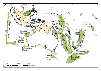
The Ontong Java Plateau (OJP) is a massive oceanic plateau located in the southwestern Pacific Ocean, north of the Solomon Islands. The OJP was formed around 116 million years ago (Ma),[1] with a much smaller volcanic event around 90 Ma. Two other southwestern Pacific plateaus, Manihiki and Hikurangi, now separated from the OJP by Cretaceous oceanic basins, are of similar age and composition and probably formed as a single plateau and a contiguous large igneous province together with the OJP.[2] When eruption of lava had finished, the Ontong Java–Manihiki–Hikurangi plateau covered 1% of Earth's surface and represented a volume of 80 million km3 (19 million cu mi) of basaltic magma.[3] This "Ontong Java event", first proposed in 1991, represents the largest volcanic event of the past 200 million years, with a magma eruption rate estimated at up to 22 km3 (5.3 cu mi) per year over 3 million years, several times larger than the Deccan Traps.[4] The smooth surface of the OJP is punctuated by seamounts such as the Ontong Java Atoll, one of the largest atolls in the world.[5][6]
YouTube Encyclopedic
-
1/3Views:550 6097121 450 363
-
The Largest Volcanoes in History – Mantle Plumes explained
-
Ontong Java Plateau
-
The Most Dangerous Type of Eruptions - Flood Volcanism explained
Transcription
Geological setting
The OJP covers 1.5 million km2 (580,000 sq mi), roughly the size of Alaska. It reaches up to 1,700 m (5,600 ft) below sea level but has an average depth closer to 2,000–3,000 m (6,600–9,800 ft). It is bounded by Lyra Basin to the northwest, East Mariana Basin to the north, Nauru Basin to the northeast, and the Ellice Basin to the southeast. The OJP has collided with the Solomon Islands island arc and now lies on the inactive Vitiaz Trench and the Pacific–Australian plate boundary.[5][6]
The high plateau, with a crustal thickness estimated to at least 25 km (16 mi) but probably closer to 36 km (22 mi),[7] has a volume of more than 5 million km3 (1.2 million cu mi). The maximum extent of the event can, however, be much larger since lavas in several surrounding basins are closely related to the OJP event and probably represent dike swarms associated with the formation of the OJP.[5][6] These swarms or eruptions involved the Ontong Java-Manihiki-Hikurangi plateaus. [2]
The OJP basaltic basement is four tholeiitic magma series called the Kwaimbaita, Kroenke, Singgalo, and Wairahito.[8] All except the Singgalo are isotopically identical so they are likely from the same mantle source.[8] It can be assumed that the Singgalo basalts have a different mantle source to the rest. The Kwaimbaita basalts are dominant and in stratigraphic series the oldest.[8][9]
Tectonic evolution
OJP formed quickly over a mantle plume head, most likely the then newly formed Louisville hotspot, followed by limited volcanism for at least 30 million years. The extant seamounts of the Louisville Ridge started to form 70 Ma and have a different isotopic composition, and therefore a shift in intensity and magma supply in the plume must have occurred before that.[10]
The early, short-duration eruptions of OJP were thought to coincide with the global Early Aptian oceanic anoxic event (known as OAE1a or the Selli Event, 125.0–124.6 Ma) that led to the deposition of black shales during the interval 124–122 Ma. However dating of the basalts to between 117 and 108 Ma makes this unlikely.[1] There are still unresolved dates by two other research groups that are 4 Ma older so the potential association is not totally eliminated,[11] however all OJP lavas are normally magnetized so are presumably dated after the Cretaceous Normal Superchron (C34, CNS) began at 120.964 Ma[12] Additionally, isotopic records of seawater in sediments have been associated with the 90 Ma OJP submarine eruptions.[13] About 80% of the OJP is being subducted beneath the Solomon Islands. Only the uppermost 7 km (4.3 mi) of the crust is preserved on the Australian Plate.[14] This collision has lifted some of the OJP between 200 and 2,000 m (660–6,560 ft) above sea level. The construction of Pliocene stratovolcanoes in the western end of the convergence zone has resulted in the New Georgia Islands (1,768 m, 5,801 ft) and Bougainville Island (2,743 m, 8,999 ft). Shortening, uplift, and erosion of the northern Melanesian arc and the Malaita accretionary prism at deep levels has produced Guadalcanal (2,447 m, 8,028 ft), Makira (1,250 m, 4,100 ft), and Malaita (1,251 m, 4,104 ft).[15]
References
Notes
- ^ a b Davidson et al. 2023, Sections:Editor's summary, Abstract
- ^ a b Taylor, B. (2006). "The single largest oceanic plateau: Ontong Java–Manihiki–Hikurangi" (PDF). Earth and Planetary Science Letters. 241 (3–4): 372–380. Bibcode:2006E&PSL.241..372T. doi:10.1016/j.epsl.2005.11.049. Retrieved 28 July 2019.
- ^ Rizo 2016
- ^ Tarduno et al. 1991, p. 401
- ^ a b c Neal et al. 1997, Physical features and gross structure of the OJP, pp. 184–187
- ^ a b c Neal, Clive R.; Mahoney, John J.; Kroenke, Loren W.; Duncan, Robert A.; Petterson, Michael G. (2013-03-18), "The Ontong Java Plateau", Large Igneous Provinces: Continental, Oceanic, and Planetary Flood Volcanism, American Geophysical Union, pp. 183–216, doi:10.1029/gm100p0183, ISBN 978-1-118-66434-6
- ^ Davidson et al. 2023, Sections:Supplementary Text:Sampled stratigraphy
- ^ a b c Davidson et al. 2023, Sections:Supplementary Text:Geochemistry of dredge samples
- ^ Davidson et al. 2023, Sections:Supplementary Material:Figure S5
- ^ Mahoney et al. 1993, Abstract
- ^ Davidson et al. 2023, Sections:Supplementary Text:Non-groundmass OJP literature ages
- ^ Ogg, JG (2020). "Geomagnetic Polarity Time Scale". Geologic Time Scale 2020. 1: 159–192. doi:10.1016/B978-0-12-824360-2.00005-X. ISBN 9780128243602.
- ^ Tejada et al. 2009, Abstract; Introduction, pp. 855–856
- ^ Mann & Taira 2004, Abstract
- ^ Mann & Taira 2004, Erosional levels of rocks in the Solomon Islands, p. 166
Sources
- Mahoney, J. J.; Storey, M.; Duncan, R. A.; Spencer, K. J.; Pringle, M. (1993). "Geochemistry and age of the Ontong Java Plateau" (PDF). The Mesozoic Pacific: geology, tectonics, and volcanism. Geophys. Monogr. Ser. Vol. 77. Washington, D. C.: Washington DC American Geophysical Union Geophysical Monograph Series. pp. 233–261. Bibcode:1993GMS....77..233M. doi:10.1029/GM077p0233. ISBN 978-0-87590-036-0. Retrieved 17 December 2016.
- Mann, P.; Taira, A. (2004). "Global tectonic significance of the Solomon Islands and Ontong Java Plateau convergent zone". Tectonophysics. 389 (3): 137–190. Bibcode:2004Tectp.389..137M. doi:10.1016/j.tecto.2003.10.024. Retrieved 18 December 2016.
- Neal, C. R.; Mahoney, J. J.; Kroenke, L. W.; Duncan, R. A.; Petterson, M. G. (1997). "The Ontong Java Plateau" (PDF). In Mahoney, J. J.; Coffin, F. (eds.). Large Igneous Provinces: Continental, Oceanic, and Planetary Flood Volcanism. Geophys. Monogr. Ser. Vol. 100. Washington D.C.: Washington DC American Geophysical Union Geophysical Monograph Series. pp. 183–216. Bibcode:1997GMS...100..183N. doi:10.1029/GM100p0183. ISBN 9781118664346. Archived from the original (PDF) on 1 January 2017. Retrieved 17 December 2016.
- Rizo, H. (September 2016). "September 2016 LIP of the Month: Phanerozoic Large Igneous Provinces sample remnants of early differentiation events on Earth". Large Igneous Provinces Commission. Retrieved 14 April 2017.
- Tarduno, J. A.; Mayer, H.; Winterer, E. L.; Sliter, W. V.; Kroenke, L.; Mahoney, J. J.; Leckie, M.; Musgrave, R.; Storey, M. (1991). "Rapid formation of Ontong Java Plateau by Aptian mantle plume volcanism" (PDF). Science. 254 (5030): 399–403. Bibcode:1991Sci...254..399T. doi:10.1126/science.254.5030.399. PMID 17742226. S2CID 7627426. Retrieved 17 December 2016.
- Taylor, Brian (31 January 2006). "The single largest oceanic plateau: Ontong Java-Manihiki-Hikurangi". Earth and Planetary Science Letters. 241 (3–4): 372–380. Bibcode:2006E&PSL.241..372T. doi:10.1016/j.epsl.2005.11.049.
- "February 2006 LIP of the Month". Large Igneous Provinces Commission. 6 February 2006.
- Tejada, M. L. G.; Suzuki, K.; Kuroda, J.; Coccioni, R.; Mahoney, J. J.; Ohkouchi, N.; Sakamoto, T.; Tatsumi, Y. (2009). "Ontong Java Plateau eruption as a trigger for the early Aptian oceanic anoxic event". Geology. 37 (9): 855–858. Bibcode:2009Geo....37..855T. doi:10.1130/G25763A.1. Retrieved 17 December 2016.
- Davidson, P. C.; Koppers, A. A. P.; Sano, T.; Hanyu, T. (2023). "A younger and protracted emplacement of the Ontong Java Plateau". Science. 380 (6650): 1185–1188. Bibcode:2023Sci...380.1185D. doi:10.1126/science.ade8666. PMID 37319200. S2CID 259166067.
Further reading
- Fitton, J. G.; Mahoney, J. J.; Wallace, P. J.; Saunders, A. D. (2004). Origin & Evolution of the Ontong Java Plateau: introduction (PDF). Vol. 229. Geological Society, London, Special Publications. p. 1. Bibcode:2004GSLSP.229....1F. CiteSeerX 10.1.1.560.1753. doi:10.1144/GSL.SP.2004.229.01.01. ISBN 978-1-86239-157-4. S2CID 129614562. Retrieved 17 December 2016.(Ocean Drilling Program: Volume 192 Scientific Results)