
Old Jamestown, Missouri | |
|---|---|
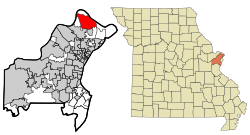 Location of Old Jamestown, Missouri | |
| Coordinates: 38°50′21″N 90°16′55″W / 38.83917°N 90.28194°W | |
| Country | United States |
| State | Missouri |
| County | St. Louis |
| Area | |
| • Total | 14.96 sq mi (38.73 km2) |
| • Land | 14.95 sq mi (38.71 km2) |
| • Water | 0.01 sq mi (0.02 km2) |
| Elevation | 538 ft (164 m) |
| Population (2020) | |
| • Total | 19,790 |
| • Density | 1,324.10/sq mi (511.23/km2) |
| Time zone | UTC-6 (Central (CST)) |
| • Summer (DST) | UTC-5 (CDT) |
| Area code | 314 |
| FIPS code | 29-54352[3] |
| GNIS feature ID | 2583784[2] |
| Website | http://www.oldjamestownassn.org |
Old Jamestown is a census-designated place (CDP) in St. Louis County, Missouri, United States. The population was 19,184 at the 2010 census.[4] Old Jamestown is northwest of the city of St. Louis and borders the Missouri River.
YouTube Encyclopedic
-
1/4Views:7 8111 8611 08042 239
-
Abandoned Jamestown Mall and More: Black Jack & Spanish Lake, Missouri 4K.
-
⚠️ Worlds most dangerous abandoned mall  Episode 3. Jamestown Mall
-
👠 Shoe Shopping 🛍 in the Worlds Most Dangerous Abandoned Mall Episode 6.
-
Jamestown Mall - Current State 2020 - Drone Footage. Florissant, Missouri - Urban Exploration
Transcription
Geography
According to the United States Census Bureau, the CDP has a total area of 14.9 square miles (38.7 km2), of which 0.008 square miles (0.02 km2), or 0.06%, is water.[4] The community is located mostly to the north and west of U.S. Route 67 in northern St. Louis County. West Alton is to the north, across the Missouri River. Florissant is to the southwest, and Black Jack and Spanish Lake are to the south. The CDP is located 17 miles (27 km) north of downtown St. Louis.
Demographics
| Census | Pop. | Note | %± |
|---|---|---|---|
| 2010 | 19,184 | — | |
| 2020 | 19,790 | 3.2% | |
| U.S. Decennial Census[5] | |||
References
- ^ "ArcGIS REST Services Directory". United States Census Bureau. Retrieved August 28, 2022.
- ^ a b U.S. Geological Survey Geographic Names Information System: Old Jamestown, Missouri
- ^ "U.S. Census website". United States Census Bureau. Retrieved January 31, 2008.
- ^ a b "Geographic Identifiers: 2010 Demographic Profile Data (G001): Old Jamestown CDP, Missouri". U.S. Census Bureau, American Factfinder. Archived from the original on February 12, 2020. Retrieved January 23, 2013.
- ^ "Census of Population and Housing". Census.gov. Retrieved June 4, 2016.
External links

| Topics |  | |
|---|---|---|
| Central city | ||
| Largest cities (over 50,000 in 2020) | ||
| Medium-sized cities (over 20,000 in 2020) | ||
| Largest towns and villages (over 10,000 in 2020) |
| |
| Missouri counties | ||
| Illinois counties | ||
| Subregions | ||