

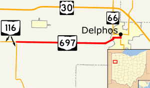
State Route 697 (SR 697, OH 697) is an east–west state highway in the western portion of Ohio, a U.S. state. The western terminus of State Route 697 is located at its junction with State Route 116 approximately 2 miles (3.2 km) southwest of Middle Point. The eastern terminus of this route is located on the northern fringe of downtown Delphos, following a nearly 0.25 miles (0.40 km) concurrency with State Route 66 at a signalized intersection that doubles as the southern terminus of State Route 190.
YouTube Encyclopedic
-
1/3Views:7781 428719
-
Idaho - Eastbound US Highway 30 just East of Montpelier
-
ISRAEL: Hiking The Shvil Israel trail - 3. Negev desert
-
Artist Steve White | Kentucky Life | KET
Transcription
Route description
This state highway runs through the eastern portion of Van Wert County, and into the extreme northwestern corner of Allen County. State Route 697 is not a part of the National Highway System.[2]
History
State Route 697 was established in 1938 along the routing that it utilizes to this day. No changes of major significance have taken place to the highway throughout its history.[3][4]
Major intersections
| County | Location | mi[1] | km | Destinations | Notes |
|---|---|---|---|---|---|
| Van Wert | Ridge Township | 0.00 | 0.00 | ||
| Allen | Delphos | 7.31 | 11.76 | Southern end of SR 66 concurrency | |
| 7.54 | 12.13 | Northern end of SR 66 concurrency; southern terminus of SR 190 | |||
1.000 mi = 1.609 km; 1.000 km = 0.621 mi
| |||||
References
- ^ a b Ohio Department of Transportation. "Technical Services Straight Line Diagrams". Retrieved 2010-09-03.
- ^ National Highway System: Ohio (PDF) (Map). Federal Highway Administration. December 2003. Retrieved 2010-09-03.
- ^ Ohio State Map (Map). Ohio Department of Transportation. 1937.
- ^ Ohio State Map (Map). Ohio Department of Transportation. 1938.