
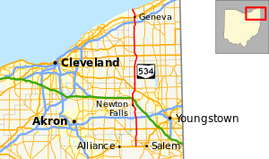
State Route 534 | ||||
|---|---|---|---|---|
 | ||||
| Route information | ||||
| Maintained by ODOT | ||||
| Length | 69.41 mi[1] (111.70 km) | |||
| Existed | 1937[2][3]–present | |||
| Major junctions | ||||
| South end | ||||
| North end | ||||
| Location | ||||
| Country | United States | |||
| State | Ohio | |||
| Counties | Mahoning, Trumbull, Ashtabula | |||
| Highway system | ||||
| ||||
| ||||


State Route 534 (SR 534) is a north–south state highway in the northeastern portion of the U.S. state of Ohio. The southern terminus of SR 534 is at its junction with the duplex of U.S. Route 62 (US 62) and SR 173 nearly 4.50 miles (7.24 km) west of Salem. Its northern terminus is a curve in Geneva-on-the-Lake where the highway directly transitions into SR 531 at that route's western terminus.
YouTube Encyclopedic
-
1/2Views:2 091594
-
Georgia State Route 20 Part 1
-
Greenfield Ohio
Transcription
Route description
SR 534's path takes it through the western portions of Mahoning, Trumbull and Ashtabula Counties. There are no segments of this highway that are included within the National Highway System (NHS). The NHS is a network of highways deemed most important for the nation's economy, mobility and defense.[4]
History
SR 534 debuted in 1937. It was originally routed along the majority of its current alignment, excepting a short stretch in northwestern Ashtabula County. Prior to its inception, SR 534 consisted of previously un-numbered roads south of Windsor, and SR 45 from Windsor north to Geneva-on-the-Lake.[2][3]
Prior to 1962, SR 534 utilized the Harpersfield Covered Bridge to cross the Grand River near Harpersfield, in the vicinity of its junction with SR 307. In that year, a new alignment of the state highway was constructed, bypassing the covered bridge to the east. As a result, the former alignment that utilized the covered bridge to pass over the Grand River was turned over to Ashtabula County, and renamed as County Road 154 (CR 154).[5][6]
Major intersections
| County | Location | mi | km | Destinations | Notes |
|---|---|---|---|---|---|
| Mahoning | Goshen Township | 0.00 | 0.00 | Southern terminus on Columbiana–Mahoning County Line | |
| 3.02 | 4.86 | Four-way stop intersection | |||
| 3.41 | 5.49 | ||||
| Berlin Township | 8.60 | 13.84 | |||
| Milton Township | 14.10 | 22.69 | Exit 54 off of I-76, a diamond interchange | ||
| Trumbull | Braceville Township | 21.98 | 35.37 | Signalized intersection | |
| 24.26 | 39.04 | Four-way stop intersection with flashing beacon | |||
| Southington Township | 28.81 | 46.37 | Signalized intersection | ||
| 29.57 | 47.59 | Five-way stop intersection | |||
| Farmington Township | 35.46 | 57.07 | |||
| Mesopotamia Township | 40.15 | 64.62 | |||
| Ashtabula | Windsor Township | 45.63 | 73.43 | ||
| 46.59 | 74.98 | T-intersection marking northwestern split of SR 86/SR 534 duplex; SR 86 departs to the northwest; Southern Terminus of SR 86 | |||
| Hartsgrove Township | 50.94 | 81.98 | Traffic circle | ||
| Trumbull Township | 54.83 | 88.24 | Eastern terminus of SR 166 | ||
| Harpersfield Township | 61.83 | 99.51 | |||
| 62.55 | 100.66 | Exit 218 off of I-90, a diamond interchange | |||
| Geneva | 63.95 | 102.92 | Signalized intersection | ||
| 65.08 | 104.74 | Signalized intersection | |||
| Geneva-on-the-Lake | 69.41 | 111.70 | Northern terminus at curve that doubles as western terminus of SR 531 | ||
1.000 mi = 1.609 km; 1.000 km = 0.621 mi
| |||||
References
- ^ Ohio Department of Transportation. "Technical Services Straight Line Diagrams". Retrieved 2006-11-16.
- ^ a b Official Ohio Highway Map (MrSID) (Map). Cartography by ODOH. Ohio Department of Highways. 1936. Retrieved 2011-03-24.
- ^ a b Official Ohio Highway Map (MrSID) (Map). Cartography by ODOH. Ohio Department of Highways. 1937. Retrieved 2011-03-24.
- ^ National Highway System: Ohio (PDF) (Map). Federal Highway Administration. December 2003. Retrieved 2011-03-22.
- ^ Official Ohio Highway Map (MrSID) (Map). Cartography by ODOH. Ohio Department of Highways. 1961. Retrieved 2011-03-24.
- ^ Official Ohio Highway Map (MrSID) (Map). Cartography by ODOH. Ohio Department of Highways. 1962. Retrieved 2011-03-24.