
| Cestos | |
|---|---|
 Liberia Cestos River | |
| Location | |
| Countries | |
| Physical characteristics | |
| Source | |
| • location | Nimba Range, Guinea |
| Mouth | |
• location | Atlantic Ocean |
| Length | 476 km (296 mi)[1] |
| Basin size | 12,723 km2 (4,912 sq mi)[2] |
| Discharge | |
| • location | Near mouth |
| • average | (Period: 1979–2015) 18.35 km3/a (581 m3/s)[2] |
| Basin features | |
| River system | Cestos River |
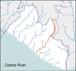
The Cestos River, also known as Nuon or Nipoué river,[3] is a Liberian river that rises in the Nimba Range of Guinea and flows south along the Côte d'Ivoire border, then southwest through tracks of Liberian rain forest to empty into a bay on the Atlantic Ocean where the city River Cess is located. The pygmy hippopotamus (Choeropsis liberiensis) is known to inhabit lands along stretches of the river.[4] It forms the northern third of the international boundary between Liberia and Côte d'Ivoire.
During the First Liberian Civil War, the portion of the river near the city of Cestos was a leading food and mineral extraction region for the National Patriotic Front of Liberia.[5]
YouTube Encyclopedic
-
1/3Views:1 6811 355582
-
Rivercess - Liberia
-
Greenville, Sinoe County, Liberia
-
Lifting Liberia
Transcription
References
- ^ "North Africa-West Coast".
- ^ a b "River Basins".
- ^ "Liberia Waterways". The Liberian Connection. Archived from the original on 5 February 2012. Retrieved 8 August 2014.
{{cite web}}: CS1 maint: unfit URL (link) - ^ Ramsar Sites Information Service. "Wetlands International Ramsar Sites Information Service: Liberia" (PDF). Archived from the original (PDF) on 2011-07-28. Retrieved 2008-08-02.
- ^ "Rivercess Falls to Allied Forces". Monrovia Daily News, 1993-05-10, 1/6.
5°27′N 9°34′W / 5.450°N 9.567°W