
 Flag  Coat of arms | |
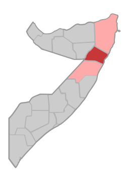 Location in northern Somalia. | |
| Coordinates: 9°6′47″N 48°00′00″E / 9.11306°N 48.00000°E | |
| Regional State | |
| Capital | Garowe |
| Government | |
| • Governor | Omar Abdullahi Mohamed |
| Area | |
| • Total | 26,180 km2 (10,110 sq mi) |
| Elevation | 1,650 m (5,410 ft) |
| Population (2019[1]) | |
| • Total | 473,900 |
| • Density | 18/km2 (47/sq mi) |
| Time zone | UTC+3 (EAT) |
| Area code | +252 |
| HDI (2021) | 0.378[2] low · 6th of 18 |
Nugal (Somali: Nugaal, Arabic: نوغال, Italian: Nogal), traditionally known as Nugaaleed-Bari or Bari-Nugaal meaning eastern Nugaal, or Nugaal xaggeeda hoose meaning lower Nugaal, is an administrative region (gobol) in northern Somalia.[3]
YouTube Encyclopedic
-
1/4Views:92016 66318 44614 209
-
MAXAAD KA TAQAANAA DEGMADA BURTINLE NUGAL SOMALIA ?
-
Eyl Safari Tour Day 2 | 4k 2021 | Somalia Tourism
-
Burtinle is one of the fastest growing cities in Puntland. Enjoy its Aerial view and visit.
-
Garowe To Eyl Safari Tour Day1 2021| 4k | Somalia Tourism
Transcription
Overview

It is bordered by Sool to the west, Bari to the north, and Mudug to the south and the Somali Region of Ethiopia. The Somali Sea flanks the province to the east. During the 1970s, Nugaal was merged with Sool province as a single province called Nugaal.[4] According to Jaamac Cumar Ciise, the eastern parts of the Nugaal are called Nugaal xaggeeda hoose or Nugaal xeebeheeda hoose, meaning lower Nugaal and lower coastal Nugaal respectively.[5] Nugal is centered on Garowe, which serves as the capital of the autonomous Puntland macro-region. The segments of the Nugaal valley from Garowe eastwards is traditionally referred to as Bari-Nugaaleed or Bari-Nugaal, whilst segments of the valley which converge into the Iyah plains are called Jednugaal. Nonetheless, Nugaal proper traditionally refers to segments of the valley west of Garowe.[6]
Garowe
Nugal is centered on Garowe, which serves as the capital of the autonomous Puntland macro-region. A major geographic feature of the region is the Nugaal Valley, a large shallow drainage basin fed by the Nugal and Dheer seasonal rivers during the April–June rainy season. The region was established on February 8, 1973.[7]
Kobo
Towards the east, Nugaal Valley is separated from Nugaaleed-Bari via the region known as Kobo. Kobo was described in colonial sources ruminating about Dervish strength as follows:[8]
During all this time the Mullah and the majority of his karias (tribal encampments) had remained in the Eastern Nogal, in the area known as Kobo, roughly comprised in the triangle Halin, Gerrowei, Kallis. His strategical position here was a very strong one. It was secure from any possible danger of surprise, and he commanded the main routes to the south
— Colonel Kenna
Districts
The Nugal region consists of five districts:[9]
- Burtinle District
- Dangorayo District
- Eyl District
- Garowe District (Administrative capital)
- Godobjiran District
Major towns

References
- ^ "Somalia: Subdivision and cities". www.citypopulation.de. Retrieved 2024-02-14.
- ^ "Sub-national HDI - Area Database - Global Data Lab". hdi.globaldatalab.org. Retrieved 2018-09-13.
- ^ "Somalia". The World Factbook. Langley, Virginia: Central Intelligence Agency. Retrieved 6 December 2013.
- ^ page 154 of the book Somalia, a country study by American University and editor Harold Nelson, 1981
- ^ Diiwaanka Gabayadii, 1999, "la mariyay guyaashii ay Daraawiishi deggenayd Nugaal xeebeheeda hoose - xeebaha Ayl iyo Ilig- ... 1904tii ayay Daraawiish udubka dhidbatay xeebaha Ayl, Ilig, Gabbac, Hawd-Bari iyo Nugaal xaggeeda hoose" (translation) "... it was produced when the Darawiish lived at the Lower coastal Nugal, on the coast of Eyl and Illi ... 1904 was when the stalwarts of the Darawiish verged upon the coasts of Illig, Gabbac, Hawd, Bari, the parts of the Lower-side Nugal"
- ^ Ismaaciil Mire , A. F. Cali ("Idaajaa.") · 1974
- ^ "Bollettino ufficiale della Repubblica democratica Somala".
- ^ Official History of the Operations in Somaliland, 1901-04 Britain. War Office. General Staff · 1907 , PAGE 230
- ^ "Nugaal Region" (PDF). Retrieved 30 January 2014.
External links

| |||