
Nong Kung Si
หนองกุงศรี | |
|---|---|
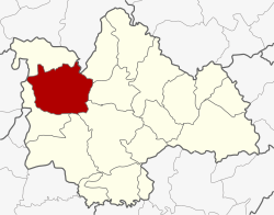 District location in Kalasin province | |
| Coordinates: 16°39′21″N 103°17′38″E / 16.65583°N 103.29389°E | |
| Country | Thailand |
| Province | Kalasin |
| Seat | Nong Kung Si |
| Area | |
| • Total | 626.944 km2 (242.064 sq mi) |
| Population (2005) | |
| • Total | 65,521 |
| • Density | 104.5/km2 (271/sq mi) |
| Time zone | UTC+7 (ICT) |
| Postal code | 46220 |
| Geocode | 4612 |
Nong Kung Si (Thai: หนองกุงศรี, pronounced [nɔ̌ːŋ kūŋ sǐː]) is a district (amphoe) in the western part of Kalasin province, northeastern Thailand.
YouTube Encyclopedic
-
1/3Views:2 0322 604 5371 052 752
-
Northern Vietnam’s UNKNOWN ROADS🇻🇳
-
Bolivie, la route de la mort | Les routes de l'impossible
-
How to Lose Belly Fat: The Complete Guide
Transcription
History
The government separated Tambon Nong Kung Si and Khok Khruea from Tha Khantho district and created Nong Kung Si minor district (king amphoe) on 14 September 1973.[1] Later Tambon Nong Bua of Sahatsakhan district was assigned to the minor district in 1975.[2] It was upgraded to a full district on 25 March 1979.[3]
Geography
Neighboring districts are (from the northeast clockwise): Sam Chai, Sahatsakhan, Mueang Kalasin, Yang Talat, and Huai Mek of Kalasin Province; Kranuan of Khon Kaen Province; Tha Khantho of Kalasin Province; and Wang Sam Mo of Udon Thani province.
Administration
The district is divided into nine sub-districts (tambons), which are further subdivided into 111 villages (mubans). There are two townships (thesaban tambons): Nong Hin covers parts of tambons Nong Hin and Dong Mun, and Nong Kung Si parts of tambons Lam Nong Saen. There are a further eight tambon administrative organizations (TAO).
| No. | Name | Thai name | Villages | Pop. | |
|---|---|---|---|---|---|
| 1. | Nong Kung Si | หนองกุงศรี | 13 | 7,698 | |
| 2. | Nong Bua | หนองบัว | 13 | 7,048 | |
| 3. | Khok Khruea | โคกเครือ | 15 | 10,485 | |
| 4. | Nong Suang | หนองสรวง | 11 | 5,501 | |
| 5. | Sao Lao | เสาเล้า | 14 | 5,795 | |
| 6. | Nong Yai | หนองใหญ่ | 15 | 8,169 | |
| 7. | Dong Mun | ดงมูล | 13 | 9,153 | |
| 8. | Lam Nong Saen | ลำหนองแสน | 8 | 5,794 | |
| 9. | Nong Hin | หนองหิน | 9 | 5,878 |
References
- ^ ประกาศกระทรวงมหาดไทย เรื่อง แบ่งท้องที่อำเภอท่าคันโท จังหวัดกาฬสินธุ์ ตั้งเป็นกิ่งอำเภอหนองกุงศรี (PDF). Royal Gazette (in Thai). 90 (114 ง): 2830. 11 September 1973. Archived from the original (PDF) on 27 April 2012.
- ^ พระราชกฤษฎีกาเปลี่ยนแปลงเขตอำเภอสหัสขันธ์ กับอำเภอเมืองกาฬสินธุ์ และกิ่งอำเภอหนองกุงศรี อำเภอท่าคันโท จังหวัดกาฬสินธุ์ พ.ศ. ๒๕๑๘ (PDF). Royal Gazette (in Thai). 92 (146 ก Special): 1–3. 1 August 1975. Archived from the original (PDF) on 27 April 2012.
- ^ พระราชกฤษฎีกาตั้งอำเภอหนองกุงศรี อำเภอไทรงาม อำเภอบ้านฝาง อำเภออุบลรัตน์ อำเภอเวียงชัย อำเภอดอยเต่า อำเภอนิคมคำสร้อย อำเภอนาหว้า อำเภอเสิงสาง อำเภอศรีสาคร อำเภอบึงสามพัน อำเภอนาดูน อำเภอค้อวัง อำเภอโพธิ์ชัย อำเภอเมืองสรวง อำเภอปลวกแดง อำเภอยางชุมน้อย อำเภอกาบเชิง อำเภอสุวรรณคูหา และอำเภอกุดข้าวปุ้น พ.ศ. ๒๕๒๒ (PDF). Royal Gazette (in Thai). 96 (42 ก Special): 19–24. 25 March 1979. Archived from the original (PDF) on 30 September 2007.
External links
This Kalasin Province location article is a stub. You can help Wikipedia by expanding it. |