

The Nomoi Islands, also known as the Mortlock Islands, are a group of three atolls in the state of Chuuk, Federated States of Micronesia. They are located approximately 250 kilometers (160 miles) southeast of Chuuk Lagoon.[1]
Islands
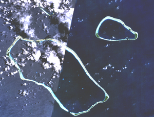
The Mortlock Islands are made up of the islands Ettal, Namoluk, Ta, Nama, Oneop, Losap, Moch, Picemwar, Satawan, Lukunor (Likinioch), and Kuttu (KuKuttu). Losap, Nama, and Namoluk are clustered to the northwest of the other islands, and are also called the Upper Mortlock Islands or Eastern Islands.
Satawan, the southern atoll, is the largest. Both Etal,[2] to the north, and Lukunor[3] to the northeast are significantly smaller. They are located between 6 and 9 kilometers (3.7 and 5.6 miles) of each other.
History
The Namoi Islands have thought to have been initially settled eight to nine hundred years ago by natives moving eastward from the Chuuk Lagoon.[4][5]
During the Age of Exploration the islands were sighted by the Spanish expedition of Álvaro de Saavedra in 1528.[6] Centuries later, Captain James Mortlock rediscovered two sets of islands when he was sailing from Port Jackson to Whampoa in Young William on the 19th and 27 November 1795. Confusingly, both were later called the Mortlock Islands.[7]
Unfortunately, due to the reliance of oral story telling to pass down history, coupled with natural disasters, war, and other factors, much of the originating people's history is lost. What is known is mostly from writings of missionaries[5] and various ancient artifacts.
Ethnography
The Mortlock Islands remain more traditional than the inner lagoon islands. The Mortlockese language is similar to that of surrounding languages, such as Satawalese, and Puluwatese, with the language of Chuukese being especially close, albeit spoken and pronounced distinctly.
See also
References
- ^ "Oceandots – Satawan". Archived from the original on December 23, 2010. Retrieved 2015-12-04.
{{cite web}}: CS1 maint: bot: original URL status unknown (link) - ^ "Oceandots – Etal". Archived from the original on December 23, 2010. Retrieved 2011-12-07.
{{cite web}}: CS1 maint: bot: original URL status unknown (link) - ^ "Oceandots – Lukunor". Archived from the original on December 23, 2010. Retrieved 2011-12-06.
{{cite web}}: CS1 maint: bot: original URL status unknown (link) - ^ Odango, Emerson Lopez. Affeu fangani 'join together': A morphophonemic analysis of possessive suffix paradigms and a discourse-based ethnography of the elicitation session in Pakin Lukunosh Mortlockese. ISBN 978-1-321-96622-0. OCLC 1257964031.
- ^ a b Odango, Emerson. 2015. Afféú Fangani ‘Join Together’: A Morphophonemic Analysis Of Possessive Suffix Paradigms And A Discourse-Based Ethnography Of The Elicitation Session In Pakin Lukunosh Mortlockese Archived 2022-10-09 at Ghost Archive. University of Hawai'i at Mānoa Ph.D. dissertation.
- ^ Riesenberg, Saul H., "Six Pacific Islands Discoveries", The American Neptune, Oct. 1974, p.249
- ^ The tale of the discovery of the two sets of “Mortlock Islands” Mariner’s Mirror, Journal of the Society for Nautical Research, May 2002.
5°29′30″N 153°37′30″E / 5.49167°N 153.62500°E
This Federated States of Micronesia location article is a stub. You can help Wikipedia by expanding it. |