
Native name: Isla Noir | |
|---|---|
 | |
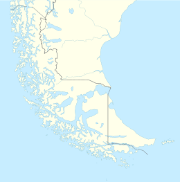 Noir Island Noir Island, a outlying island of the Tierra del Fuego labyrinth | |
| Geography | |
| Coordinates | 54°29′S 73°02′W / 54.483°S 73.033°W |
| Archipelago | Tierra del Fuego |
| Adjacent to | Pacific ocean |
| Highest elevation | 183 m (600 ft) |
| Administration | |
| Region | Magallanes Region |
| Province | Punta Arenas |
| Commune | Punta Arenas |
| Additional information | |
| NGA UFI -893783 | |
Noir Island (Spanish: Isla Noir) is an island located 27 km (17 mi) west of Tierra del Fuego. Cabo Noir (sometimes called "Cape Noir" in English) is the southwestern cape of Isla Noir.[1] The island reaches a height of approximately 180 metres (600 ft).
In literature
Cape Noir plays a crucial role in a dramatic episode in Patrick O'Brian's novel, The Golden Ocean, which is based on the historical events of Commodore George Anson's circumnavigation of the world. In the story, a squadron of ships believes they have successfully rounded Cape Horn westwards[2] and reached safe waters. However, upon sighting Cape Noir, they are confronted with the shocking realization that their longitude reckoning is grossly in error.
The episode is described by the chaplain of the Centurion:[3]
It was indeed most wonderful, that the currents should have driven us to the eastward with such strength; for the whole squadron esteemed themselves upwards of ten degrees more westerly than this land, so that in running down, by our account, about nineteen degrees of longitude, we had not really advanced half that distance. And now, instead of having our labours and anxieties relieved by approaching a warmer climate and more tranquil seas, we were to steer again to the southward, and were again to combat those western blasts, which had so often terrified us; and this too, when we were greatly enfeebled by our men falling sick, and dying apace, and when our spirits, dejected by a long continuance at sea, and by our late disappointment, were much less capable of supporting us in the various difficulties, which we could not but expect in this new undertaking.
References
- ^ Carteret's voyage round the world, 1766-1769: "Cape Noir, the south-west cape of Noir Island, 54° 31' S, 73° 05' W."
- ^ Sobel, Dava (2011). Longitude. USA: Fourth Estate. p. 17. ISBN 9780007382002.
- ^ Richard Walter (1749). A voyage round the world in the years MDCCXL, I, II, III, IV. John and Paul Knapton., p. 83
External links
- United States Hydrographic Office, South America Pilot (1916)