
| Noel Besi Rever Noil Besi, Noe Besi, River Besi | |
|---|---|
 | |
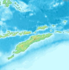 Location of river mouth | |
| Location | |
| Countries |
|
| Province | East Nusa Tenggara |
| Region | Oecussi |
| Physical characteristics | |
| Source | |
| • location | West Timor, Indonesia |
| • elevation | 820 m (2,690 ft) |
| Mouth | Sawu Sea |
• location | North of Oehoso,[1] Indonesia; East Timor |
• elevation | 5 m (16 ft) |
The Noel Besi River is a river flowing in the west part of Timor island and forms part of the border between the East Timor exclave of Oecussi and Indonesian West Timor.[2] It flows north into the Sawu Sea. Located 1900 km east of the Indonesian capital, Jakarta.[3]
YouTube Encyclopedic
-
1/5Views:3 321 15339 869237 02451 0352 443
-
12 Moments You Wouldn’t Believe If Not Filmed
-
Beautiful Village in Surrey Hills - SHERE Village - Village Walk and History
-
GLAMPING in CANADA (TINY HOUSE in New Brunswick by the River!) + Visiting KING'S LANDING village
-
SUB/[브이로그] Girlsnight!!🍾🥂 한남동 브이라운지에서 친구랑 핫한밤 보내기/크로와상샌드위치/샐러드/케비어/샴페인/일상브이로그/파티브이로그/seoulvlog
-
Eagel View Farm - Montgomery county Virginia 4 27 09
Transcription
Hydrology
The river rises in the mountains of West Timor as Oelvab. It is formed from several tributaries, the longest and southernmost rises to about 820 m in height. After the merging of the tributaries, the river winds north through the mountains. Below the Kali Aplal the Oelvab continues to flow towards the northeast, where after a few kilometers it merges with two other rivers.[4] As soon as it reaches the East Timorese Suco Malelat, it forms the border between Indonesia and East Timor.[1]
From Suco Malelat, the river now called Rio Kusi flows in northwest direction along the border of the Sucos Banafi and Lela-Ufe, before reaching the Suco Usi-Taco. The river bends sharply to southwest and flows along the border of Suco Beneufe. Just south of the village Lamasi it bends again to the northwest. The river now widens, forming river islands and tributaries. Just south of the village Naktuka the river splits. While the left arm, forming several lakes, flows further northwest to Sawu Sea, the right arm bends to the northeast. Both arms are crossed by the northern coastal road, with two bridges over the right arm. This arm flows between Oehoso and Manan on the right side and Naktuka on the left, forming more river islands and several tributaries, and also flows into the Sawu Sea a little later[1]
Geography
| J | F | M | A | M | J | J | A | S | O | N | D |
|---|---|---|---|---|---|---|---|---|---|---|---|
331 25 21 | 305 24 21 | 238 24 21 | 106 26 21 | 116 26 21 | 78 26 20 | 26 28 20 | 7 30 20 | 8 33 21 | 28 33 22 | 102 30 22 | 276 26 22 |
Source: [5]
| J | F | M | A | M | J | J | A | S | O | N | D |
|---|---|---|---|---|---|---|---|---|---|---|---|
13 77 70 | 12 75 70 | 9.4 75 70 | 4.2 79 70 | 4.6 79 70 | 3.1 79 68 | 1 82 68 | 0.3 86 68 | 0.3 91 70 | 1.1 91 72 | 4 86 72 | 11 79 72 |
The river flows in the northwest part of Timor with predominantly tropical savanna climate (designated as Aw in the Köppen-Geiger climate classification).[6] The annual average temperature in the area is 24 °C. The warmest month is October, when the average temperature is around 28 °C, and the coldest is February, at 22 °C.[5] The average annual rainfall is 1621 mm. The wettest month is January, with an average of 331 mm rainfall, and the driest is August, with 7 mm rainfall.[7]
Border
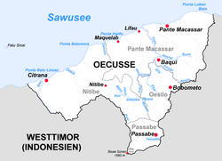
The Noel Besi forms the "Noel Besi-Citrana border" area between Kupang Regency, East Nusa Tenggara, Indonesia, and Ambeno Regency, which belongs to East Timor. This area is watered Noel Besi river which discharges into Ombai Strait. In the period of Portuguese colonization, the river flowed on the east side of the disputed area, but due to the natural climate change, the river shifted to the right side of the disputed area, which has now become a fertile agricultural heritage land with the current Noel Besi river.[8]
The small village Naktuka is in the eastern part of administrative village Netemnanu, District of Amfoang, Kupang Regency, and located exactly on the border between Indonesia and East Timor. Now the area of 1,069 hectare has a "free zone" status, cannot be entered by population of both country, although historically, Naktuka belonged to Indonesia, according to the agreement between Portugal and the Netherlands in 1904.[9] In 2017, 63 families from East Timor occupied Naktuka, with immigration office, church, electric network and meeting place of the Oecusse people.[9]
Originally the border between Amfoang and East Timor was the Noel Besi, but now the East Timor people has crossed the border up to 3 km until the stream of Nonomna.[9] One meter from the stream is the Indonesian army outpost. This stream is claimed by East Timor as the border between Indonesia and East Timor.[9] Indonesia wants the Noel Besi as its area according to toponym, whereas East Timor wants the Nono Nomna River based on compass azimuth.[10]
References
- ^ a b c "Timor-Leste GIS-Portal". Archived from the original on 30 June 2007. Retrieved 29 November 2018.
- ^ Tony Wheeler, Xanana Gusmao, Kristy Sword-Gusmao (1 November 2004). East Timor. Lonely Planet (1 ed.). Oakland: Footscray. p. 152. ISBN 978-1740596442.
{{cite book}}: CS1 maint: multiple names: authors list (link) - ^ Noe Besi at Geonames.org (cc-by); Last updated 17 January 2012; Database dump downloaded 27 November 2015
- ^ Google Earth
- ^ a b "NASA Earth Observations Data Set Index". NASA. 30 January 2016.
- ^ Peel, M C; Finlayson, B L; McMahon, T A (2007). "Updated world map of the Köppen-Geiger climate classification" (PDF). Hydrology and Earth System Sciences. 11 (5): 1633–1644. Bibcode:2007HESS...11.1633P. doi:10.5194/hess-11-1633-2007.
- ^ "NASA Earth Observations: Rainfall (1 month – TRMM)". NASA/Tropical Rainfall Monitoring Mission. 30 January 2016.
- ^ RI-Timor Leste Targetkan Perundingan Batas Darat Rampung Tahun Ini – Seysha Desnikia, detikNews, 31 Januari 2018
- ^ a b c d Sengketa Naktuka,Tokoh Adat Amfoang : “Kalau Pemerintah Tak Serius, Kita Pakai Cara Sendiri”. Tribun News, 15 Maret 2017
- ^ Noel Besi Pasti Dibahas, Harian Nasional, 25 Januari 2016.
Further reading
- Wheeler, T. (2004) East Timor. Footscray, VIC; Lonely Planet.
9°19′34″S 124°04′46″E / 9.3260°S 124.0794°E