
Neustadt (Aisch)-Bad Windsheim | |
|---|---|
 Flag 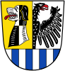 Coat of arms | |
 | |
| Country | Germany |
| State | Bavaria |
| Adm. region | Middle Franconia |
| Capital | Neustadt (Aisch) |
| Government | |
| • District admin. | Helmut Weiß (CSU) |
| Area | |
| • Total | 1,267.54 km2 (489.40 sq mi) |
| Population (31 December 2022)[1] | |
| • Total | 103,303 |
| • Density | 81/km2 (210/sq mi) |
| Time zone | UTC+01:00 (CET) |
| • Summer (DST) | UTC+02:00 (CEST) |
| Vehicle registration | NEA, SEF, UFF |
| Website | www |
Neustadt (Aisch)-Bad Windsheim (German: Landkreis Neustadt an der Aisch-Bad Windsheim, official Landkreis Neustadt a.d.Aisch-Bad Windsheim) is a Landkreis (district) in Bavaria, Germany. It is bounded by (from the west and clockwise) the districts of Würzburg, Kitzingen, Bamberg, Erlangen-Höchstadt, Fürth and Ansbach, and by the state of Baden-Württemberg (district Main-Tauber).
YouTube Encyclopedic
-
1/5Views:7565342 129565978
-
D: Stadt Bad Windsheim. Landkreis Neustadt an der Aisch-Bad Windsheim. Stadtrundfahrt. Februar 2018
-
D: Gemeinde Dietersheim. Landkreis Neustadt an der Aisch-Bad Windsheim. Oktober 2015
-
D: Kreisstadt Neustadt a.d.Aisch. Landkreis Neustadt an der Aisch-Bad Windsheim. Oktober 2015
-
D: Gemeinde Münchsteinach. Landkreis Neustadt an der Aisch-Bad Windsheim. Oktober 2015
-
D: Gemeinde Diespeck. Landkreis Neustadt a.d.Aisch-Bad Windsheim. Oktober 2015
Transcription
History
The district was established in 1972 by merging the former districts of Neustadt (Aisch), Uffenheim and Scheinfeld.
Geography
The district is covered by the Steigerwald and Frankenhöhe nature parks, both comprising large forested and hilly areas. The Aisch, a small affluent of the Regnitz River, runs through the district from southwest to northeast, with all main towns of the district on its banks.
Economy
In 2017 (latest data available) the GDP per inhabitant was €29,307. This places the district 82nd out of 96 districts (rural and urban) in Bavaria (overall average: €46,698).[2]
Coat of arms
The coat of arms displays:
- the dog from the arms of the margraves of Nuremberg
- the eagle from the arms of the Hohenzollern dynasty
- the blue and white bars from the lords of Seinsheim
Towns and municipalities
Towns:
Municipalities:
- Baudenbach
- Burghaslach
- Dachsbach
- Diespeck
- Dietersheim
- Emskirchen
- Ergersheim
- Gallmersgarten
- Gerhardshofen
- Gollhofen
- Gutenstetten
- Hagenbüchach
- Hemmersheim
- Illesheim
- Ippesheim
- Ipsheim
- Langenfeld
- Markt Bibart
- Markt Erlbach
- Markt Nordheim
- Markt Taschendorf
- Marktbergel
- Münchsteinach
- Neuhof an der Zenn
- Oberickelsheim
- Obernzenn
- Oberscheinfeld
- Simmershofen
- Sugenheim
- Trautskirchen
- Uehlfeld
- Weigenheim
- Wilhelmsdorf
References
- ^ Genesis Online-Datenbank des Bayerischen Landesamtes für Statistik Tabelle 12411-003r Fortschreibung des Bevölkerungsstandes: Gemeinden, Stichtag (Einwohnerzahlen auf Grundlage des Zensus 2011).
- ^ "VGR der Länder, Kreisergebnisse für Deutschland - Bruttoinlandsprodukt, Bruttowertschöpfung in den kreisfreien Städten und Landkreisen der Bundesrepublik Deutschland 2000 bis 2017 (German)". Statistische Ämter der Länder und des Bundes. Retrieved 4 February 2020.
External links
- Official website (German)
Towns and municipalities in Neustadt (Aisch)-Bad Windsheim | ||
|---|---|---|
|  | |
49°35′N 10°30′E / 49.58°N 10.5°E
| International | |
|---|---|
| National | |