
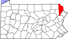
This is a list of the National Register of Historic Places listings in Wayne County, Pennsylvania.
This is intended to be a complete list of the properties and districts on the National Register of Historic Places in Wayne County, Pennsylvania, United States. The locations of National Register properties and districts for which the latitude and longitude coordinates are included below, may be seen in a map.[1]
There are 17 properties and districts listed on the National Register in the county. One site is further designated as a National Historic Landmark.
This National Park Service list is complete through NPS recent listings posted December 8, 2023.[2]
YouTube Encyclopedic
-
1/1Views:3 175
-
Founding Fragments - Political Comic Books
Transcription
Lots of kids growing up in the USA might dream of becoming President of the United States... (record scratch) or being a comic book superhero! but I never knew I could have been BOTH! As we all know, politicians will do just about anything to get their face and message out there, especially if it means capturing that elusive youth vote. So what was the presidential hopeful to do before TVs invaded all our living rooms? They got their message out on whatever they could: radio, badges, banners, buttons, ribbons. But that brings us back to the first question: how did they target young voters? The late 1940s and 1950s were the heyday of the political comic book. (music) From bureaucrats to sitting presidents, Republicans and Democrats, everyone was in on it. Today we'll be talking to curator Larry Bird who's part of our political history division. It's his responsibility to take care of a lot of our presidential campaign collection so he's the perfect person to ask as to why guys like Harry Truman, Dwight Eisenhower, and Richard Nixon have their own comic books. Larry, thank you for joining us today. Thanks for inviting me in. Excellent. So I see you've got a bunch of folders here and they're all chock full of comic books. Right? When we talk about comic books I mean most people are familiar with the colorful strip story format, almost a storyboarded kind of thing that's bound; and the first one that we have in our collection that even approximates something like that was from the 1930s and it's a picture life of a great American which happens to have been Herbert Hoover that appears to have been done as a kind-of-a just a one-off. But it isn't really until 1948 that you get an example of the format that you think would be familiar today And that's with the Democratic National Committee's story of Harry S. Truman. And this the story begins with Vice President Truman learning about the death of President Roosevelt, FDR, the way that most Americans did, which is sitting around the radio. And so from that shock it goes back in time and dramatizes his rather average and ordinary life in Missouri up until the time he joins the Congress, and then is elected Roosevelt's vice president. So I see also that this one obviously has a lot more color, it's got a lot more of the kinda bubble-talking this looks a lot more like the kinda comic book that we recognize. Right, and again even though it's packed with information it isn't that packed that it doesn't move along as a kind of an aesthetic accomplishment. So after the Truman story every campaign had to have comic; but for my money that the penultimate example is in 1956 and it's this one which was drawn up for the Eisenhower/Nixon campaign. Wow. With their themes of peace, progress, prosperity; it suggests it's a pretty strong statement of the parallels between voting and consumption And there's a page in which it focuses on a housewife who goes shopping, and she comes up with a what she calls a shopping list kinda ballot. And there's no doubt as to where you know she's calling your attention. The point of the pencil goes to Republicans, and I just It says: "Peace, tax cuts." Republicans, peace; Democrats, war. Republicans, tax cuts; Democrats, highest taxes in history. And so it goes all the way down to peacetime jobs for everyone, wars to solve unemployment. Not being subtle. But she's she's coming to this conclusion with her list up outside a grocery store and then the next little bubble shows the hand in the in the voting machine polling the lever for the Republican party. So there really isn't anything very much that's left to chance in any these things which is why I like them. They are very straightforward. And they're not... they're completely transparent and they so elegantly express in just unvarnished terms what the aims are and even who the audience is. Yes. Tell us about that. The average voter. The job of any political medium is to get down where the voter lives, and to put itself between your eyes and the candidate; to get his or her message in front of you. And that's what this storyboard format does so well. Now I have to ask, I know the answer is probably no, but when I first think about presidential comic books i really wanna see Harry Truman in a cape. Are there any presidential candidate comic books of them fighting crime? Not as an imaginative candidate. I mean that's sort of a tricky tricky terrain, but we do have other examples where they show up as themselves in these fantastic situations. We have some examples of Barack Obama in a comic. And of course along with that you have a now celebrated Spiderman. Yeah, that's where I'm going! Well this has been reallyinteresting and who would have thought we had comic books like this. It surprised me when I started working here. It's not the kind of thing that you expect to see. The format is so familiar but the subject matter is just so... Buttons, hats, signs: those are understandable. So obtuse. These are very new. Well this has been really interesting! Thank you for joining us and sharing all this great stuff. You're welcome. Thank you for joining us today on our fourth episode. Remember to visit our website to check out what objects we'll be doing next and submit any questions you got. We're always looking for good ideas. See you next time!
Current listings
| [3] | Name on the Register | Image | Date listed[4] | Location | Municipality | Description |
|---|---|---|---|---|---|---|
| 1 | Bellemonte Silk Mill |  |
June 28, 2010 (#10000407) |
230 Welwood Ave. 41°28′19″N 75°10′20″W / 41.471944°N 75.172222°W | Hawley | |
| 2 | Bridge in Dreher Township |  |
June 22, 1988 (#88000871) |
Legislative Route 171 over Haags Mill Creek 41°17′17″N 75°19′52″W / 41.288056°N 75.331111°W | Dreher Township | |
| 3 | Damascus Historic District |  |
August 14, 1992 (#92001000) |
Roughly Pennsylvania Route 371 from Galilee Road to the Delaware River and adjacent part of Route 63027 south of Pennsylvania Route 371 41°42′37″N 75°04′15″W / 41.710278°N 75.070833°W | Damascus Township | |
| 4 | Delaware and Hudson Canal |  |
November 24, 1968 (#68000051) |
Delaware and Hudson Canal 41°34′20″N 75°15′21″W / 41.572222°N 75.255833°W | Honesdale | Extends into Pike County; Wayne County component is the company's former offices in Honesdale[5] |
| 5 | Eugene Dorflinger Estate |  |
September 18, 1978 (#78002483) |
U.S. Route 6 and Charles Street in White Mills 41°31′32″N 75°12′12″W / 41.525556°N 75.203333°W | Texas Township | |
| 6 | Equinunk Historic District |  |
November 12, 1999 (#99001336) |
Generally following Pennsylvania Route 191, Pine Mill, Lordville, and Grocery Hill Roads in Equinunk 41°51′18″N 75°13′37″W / 41.855°N 75.226944°W | Buckingham and Manchester Townships | |
| 7 | Hill's Sawmill |  |
November 8, 1974 (#74001816) |
South of Equinunk off Pennsylvania Route 191 41°45′09″N 75°11′36″W / 41.7525°N 75.193333°W | Damascus Township | |
| 8 | Honesdale Residential Historic District |  |
February 6, 1998 (#97001670) |
Roughly bounded by the Lackawaxen River, Dyberry Creek, the Dyberry Cemetery, and Overlook and 18th Streets 41°34′51″N 75°15′35″W / 41.580833°N 75.259722°W | Honesdale | |
| 9 | Lacawac |  |
August 9, 1979 (#79002367) |
East of Ledgedale 41°22′43″N 75°17′40″W / 41.378611°N 75.294444°W | Paupack and Salem Townships | |
| 10 | Milanville Historic District |  |
April 29, 1993 (#93000352) |
Roughly Legislative Route 63027 from the junction with Legislative Route 63029 east to Skinner's Falls Bridge via Bridge Approach Road, in Milanville 41°40′16″N 75°03′48″W / 41.671111°N 75.063333°W | Damascus Township | |
| 11 | Milanville-Skinners Falls Bridge |  |
November 14, 1988 (#88002167) |
Legislative Route 63027 over the Delaware River at Milanville 41°40′10″N 75°03′31″W / 41.669444°N 75.058611°W | Damascus Township | Extends into Cochecton in Sullivan County, New York |
| 12 | J.S. O'Connor American Rich Cut Glassware Factory |  |
March 23, 2005 (#05000206) |
120 Falls Avenue 41°28′31″N 75°10′17″W / 41.475278°N 75.171389°W | Hawley | |
| 13 | Octagon Stone Schoolhouse |  |
May 6, 1977 (#77001200) |
1 mile (1.6 km) southwest of South Canaan 41°29′42″N 75°25′53″W / 41.495°N 75.431389°W | South Canaan Township | |
| 14 | Patriotic Order Sons of America Washington Camp 422 |  |
December 27, 2010 (#10001068) |
465 South Sterling Road 41°16′28″N 75°20′11″W / 41.274361°N 75.336389°W | Dreher Township | |
| 15 | Starlight Station, New York, Ontario, and Western Railway |  |
August 30, 2001 (#01000925) |
O&W Road northeast of Depot Hill Road, Starlight 41°54′14″N 75°19′46″W / 41.903889°N 75.329444°W | Buckingham Township | |
| 16 | Wilmot House |  |
February 15, 1974 (#74001815) |
Wayne Street 41°36′46″N 75°17′03″W / 41.612778°N 75.284167°W | Bethany | |
| 17 | Wilmot Mansion |  |
January 26, 1978 (#78003172) |
Wayne and Sugar Streets 41°36′47″N 75°17′06″W / 41.613056°N 75.285°W | Bethany |
Former listing
| [3] | Name on the Register | Image | Date listed | Date removed | Location | Municipality | Description |
|---|---|---|---|---|---|---|---|
| 1 | Stone Arch Bridge | October 21, 1977 (#77001201) | June 27, 1986 | Starrucca Creek | Starrucca |
See also
References
- ^ The latitude and longitude information provided in this table was derived originally from the National Register Information System, which has been found to be fairly accurate for about 99% of listings. Some locations in this table may have been corrected to current GPS standards.
- ^ National Park Service, United States Department of the Interior, "National Register of Historic Places: Weekly List Actions", retrieved December 8, 2023.
- ^ a b Numbers represent an alphabetical ordering by significant words. Various colorings, defined here, differentiate National Historic Landmarks and historic districts from other NRHP buildings, structures, sites or objects.
- ^ The eight-digit number below each date is the number assigned to each location in the National Register Information System database, which can be viewed by clicking the number.
- ^ McDermott, John D., and Patty Henry. National Historic Landmark Nomination: Delaware and Hudson Canal. National Park Service, 2008-03-14, 13. Accessed 2016-01-17.

Municipalities and communities of Wayne County, Pennsylvania, United States | ||
|---|---|---|
| Boroughs |  | |
| Townships | ||
| CDPs | ||
| Other communities | ||
| Footnotes | ‡This populated place also has portions in an adjacent county or counties | |