

This is a list of the National Register of Historic Places listings in Fountain County, Indiana.
This is intended to be a complete list of the properties and districts on the National Register of Historic Places in Fountain County, Indiana, United States. Latitude and longitude coordinates are provided for many National Register properties and districts; these locations may be seen together in a map.[1]
There are 18 properties and districts listed on the National Register in the county.
Properties and districts located in incorporated areas display the name of the municipality, while properties and districts in unincorporated areas display the name of their civil township. Properties and districts split between multiple jurisdictions display the names of all jurisdictions.
This National Park Service list is complete through NPS recent listings posted January 19, 2024.[2]
YouTube Encyclopedic
-
1/5Views:7253451 888990689
-
A History of the Adams County Historical Society: 1888-2017
-
Historiography | Wikipedia audio article
-
Charles Carroll of Carrollton
-
Genealogical Research in Maryland
-
Martha Norkunas: Listening Across Differences (Presentation)
Transcription
Current listings
| [3] | Name on the Register[4] | Image | Date listed[5] | Location | City or town | Description |
|---|---|---|---|---|---|---|
| 1 | Attica Downtown Historic District |  |
September 16, 1993 (#93000951) |
Roughly Perry St. between Jackson and Ferry Sts. and Main and Mill Sts. between 3rd and Brady Sts. 40°17′39″N 87°14′59″W / 40.2942°N 87.2497°W | Attica | |
| 2 | Attica Main Street Historic District |  |
June 10, 1994 (#94000581) |
Roughly bounded by Jackson, Brady, Short, and Canada Sts. 40°17′33″N 87°14′47″W / 40.2925°N 87.2464°W | Attica | |
| 3 | Bethel Church and Graveyard |  |
March 3, 1995 (#95000203) |
Bethel Rd., 0.5 miles west of its junction with Riverside Rd. and east of Attica 40°17′47″N 87°10′39″W / 40.2964°N 87.1775°W | Logan Township | |
| 4 | Brady Street Historic District | 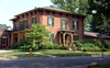 |
December 7, 1990 (#90001785) |
Roughly bounded by S. Perry, E. Jackson, S. Council, and E. Pike Sts. 40°17′26″N 87°14′56″W / 40.2906°N 87.2489°W | Attica | |
| 5 | Cades Mill Covered Bridge |  |
May 24, 2021 (#100006570) |
Cades Hollow Rd. over Coal Cr. 40°03′50″N 87°18′44″W / 40.0639°N 87.3123°W | Veedersburg vicinity | |
| 6 | Carnegie Library of Covington |  |
April 3, 1989 (#89000239) |
622 S. 5th St. 40°08′26″N 87°23′40″W / 40.1406°N 87.3944°W | Covington | |
| 7 | Covington Courthouse Square Historic District |  |
September 14, 2015 (#15000593) |
Roughly bounded by 3rd St. and alleys north of Washington, east of 4th, and south of Liberty Sts. 40°08′13″N 87°23′50″W / 40.1369°N 87.3971°W | Covington | |
| 8 | Covington Residential Historic District |  |
September 14, 2015 (#15000594) |
Roughly bounded by Pearl, Liberty, 4th, and 7th Sts. 40°08′22″N 87°23′44″W / 40.1395°N 87.3955°W | Covington | |
| 9 | Fountain County Clerk's Building |  |
June 27, 2002 (#02000692) |
516 4th St. 40°08′20″N 87°23′49″W / 40.1389°N 87.3969°W | Covington | |
| 10 | Fountain County Courthouse |  |
March 19, 2008 (#08000191) |
301 4th St. 40°08′12″N 87°23′50″W / 40.1367°N 87.3972°W | Covington | |
| 11 | Clinton F. Hesler Farm |  |
July 13, 1989 (#89000770) |
County Road 450S between 200E and 300E, southeast of Veedersburg 40°03′39″N 87°12′56″W / 40.0608°N 87.2156°W | Millcreek Township | |
| 12 | James and Lucinda McDonald House |  |
September 12, 2016 (#16000611) |
500 E. Jackson St. 40°17′28″N 87°14′32″W / 40.2911°N 87.2422°W | Attica | |
| 13 | Marshall M. Milford House |  |
January 26, 1989 (#88003037) |
414 E. Main St. 40°17′33″N 87°14′41″W / 40.2925°N 87.2447°W | Attica | |
| 14 | Old East Historic District |  |
November 28, 1990 (#90001784) |
400 block of E. Washington St. and the 400 and 500 blocks of E. Monroe St. 40°17′21″N 87°14′41″W / 40.2892°N 87.2447°W | Attica | |
| 15 | Rob Roy Covered Bridge | 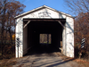 |
May 25, 2021 (#100006571) |
Covered Bridge Rd. over Big Shawnee Cr. 40°14′37″N 87°14′46″W / 40.2437°N 87.2461°W | Rob Roy vicinity | |
| 16 | William C.B. Sewell House |  |
October 11, 1984 (#84000027) |
602 E. Washington St. 40°08′16″N 87°23′39″W / 40.1378°N 87.3942°W | Covington | |
| 17 | Veedersburg Clover Leaf Route Depot | August 21, 2020 (#100005516) |
295 East 2nd St. 40°06′47″N 87°15′35″W / 40.1131°N 87.2598°W | Veedersburg | ||
| 18 | Wallace Covered Bridge |  |
May 24, 2021 (#100006568) |
Off Lutheran Church Rd. over Sugar Mill Cr. 39°59′06″N 87°08′40″W / 39.9850°N 87.1444°W | Wallace |
See also
- List of National Historic Landmarks in Indiana
- National Register of Historic Places listings in Indiana
- Listings in neighboring counties: Montgomery, Parke, Tippecanoe, Vermillion, Warren
- List of Indiana state historical markers in Fountain County
References
- ^ The latitude and longitude information provided in this table was derived originally from the National Register Information System, which has been found to be fairly accurate for about 99% of listings. Some locations in this table may have been corrected to current GPS standards.
- ^ National Park Service, United States Department of the Interior, "National Register of Historic Places: Weekly List Actions", retrieved January 19, 2024.
- ^ Numbers represent an alphabetical ordering by significant words. Various colorings, defined here, differentiate National Historic Landmarks and historic districts from other NRHP buildings, structures, sites or objects.
- ^ "National Register Information System". National Register of Historic Places. National Park Service. March 13, 2009.
- ^ The eight-digit number below each date is the number assigned to each location in the National Register Information System database, which can be viewed by clicking the number.
| Topics | |
|---|---|
| Lists by state |
|
| Lists by insular areas | |
| Lists by associated state | |
| Other areas | |
| Related | |

Municipalities and communities of Fountain County, Indiana, United States | ||
|---|---|---|
| Cities |  | |
| Towns | ||
| Townships | ||
| CDPs | ||
| Other communities | ||