
Naogaon Sadar
নওগাঁ সদর | |
|---|---|
 Balihar Rajbari | |
 | |
| Coordinates: 24°48.3′N 88°57′E / 24.8050°N 88.950°E | |
| Country | |
| Division | Rajshahi |
| District | Naogaon |
| Headquarters | Naogaon |
| Government | |
| • Type | Upazila Parishad |
| • Chairman | Rafiqul Islam |
| Area | |
| • Total | 275.72 km2 (106.46 sq mi) |
| Population (2011) | |
| • Total | 405,148 |
| • Density | 1,500/km2 (3,800/sq mi) |
| Time zone | UTC+6 (BST) |
| Website | Official Map of Naogaon Sadar |
Naogaon Sadar (Bengali: নওগাঁ সদর) is an Upazila of Naogaon District in Rajshahi Division, Bangladesh.
YouTube Encyclopedic
-
1/5Views:6 67220 3252 2671 143 18336 810
-
Naogaon sadar upazila Park | Near Naogaon police Lines, পাবলিক প্লেছে এরা কি করছে |@biker Vlogs
-
নওগাঁ জেলার ইতিহাস সম্পর্কে জানুন | | বিখ্যাত কেন | All About Naogaon district | Aalap-আলাাপ
-
Naogaon Sadar Hospital | Travel Vlog | OVINOVO | New Video 2021| নওগাঁ সদর হাসপাতাল
-
গ্রামের হাটের মাটির মানুষ || নওগাঁর আত্রাই উপজেলার আহসানগঞ্জ হাট || Village Market || Naogaon
-
নওগাঁর দর্শনীয় দশটি স্থান || পাহাড়পুর বৌদ্ধ বিহার || Naogaon 10 tourist places travel guidelines.
Transcription
History
In British India sub-districts were called as "Thana", which were mainly exercised by the police. When development activities became widespread, it was known as a Development Circle. In 1949, Naogaon Sadar was declared as a Thana, in 1960 as a development circle and in 1984 as a sub-district.[1]
Geography

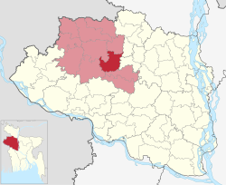
Naogaon Sadar is located at 24°48′15″N 88°57′00″E / 24.8042°N 88.9500°E. It has more than 80,000 households and total area of about 275.72 km2. It is bounded by Badalgachhi and Mahadebpur upazilas on the north, Raninagar and Manda upazilas on the south, Adamdighi and Akkelpur upazilas on the east, Mahadebpur and Manda upazilas on the west.[2]
Demographics
According to the 2011 Bangladesh census, Naogaon Sadar Upazila had 100,867 households and a population of 405,148. 76,019 (18.76%) were under 10 years of age. Naogaon Sadar had a literacy rate (age 7 and over) of 53.49%, compared to the national average of 51.8%, and a sex ratio of 981 females per 1000 males. 150,549 (37.16%) lived in urban areas.[3] Ethnic population was 1,303 (0.32%)[4]
Administration
Naogaon Sadar Upazila is divided into Naogaon Municipality and 12 union parishads: Baktiarpur, Balihar, Barshail, Boalia, Chandipur, Dubalhati, Hapania, Hashaighari, Kirtipur, Sailgachhi, Shikarpur, and Tilakpur. The union parishads are subdivided into 237 mauzas and 211 villages.[3]
- Upazila Parishad Chairman: Rafiqul Islam
- MP of Naogaon-5 Constituencies: Barrister Nizam Uddin Jalil John
- Mayor of Naogaon Municipality: Nazmul Haque Sony
Education
According to Banglapedia, Chak Atitha High School, founded in 1914, and Kirtipur Multilateral High School, founded in 1921, are notable secondary schools in the upazila.[5]
See also
References
- ^ এক নজরে উপজেলা [Sub-district at a glance]. Dcnaogaon.gov.bd (in Bengali). Retrieved 19 January 2013.
- ^ "Naogaon Sadar Upazila - Banglapedia". en.banglapedia.org. Retrieved 2023-02-23.
- ^ a b c "Bangladesh Population and Housing Census 2011 Zila Report – Naogaon" (PDF). bbs.gov.bd. Bangladesh Bureau of Statistics.
- ^ "Community Tables: Naogaon district" (PDF). bbs.gov.bd. Bangladesh Bureau of Statistics. 2011.
- ^ Rahman, Md. Moklesur (2012). "Naogaon Sadar Upazila". In Islam, Sirajul; Jamal, Ahmed A. (eds.). Banglapedia: National Encyclopedia of Bangladesh (Second ed.). Asiatic Society of Bangladesh.
External links
- Official website (in Bengali)
Capital: Naogaon | ||
| Upazilas | ||
| Constituencies | ||
| Attractions and sites | ||
| History | ||
| Inhabited areas | ||
| Rivers and transport | ||
| Educational institutions |
| |
Headquarters: Rajshahi | ||
| Bogra District |  | |
| Joypurhat District | ||
| Naogaon District | ||
| Natore District | ||
| Nawabganj District | ||
| Pabna District | ||
| Rajshahi District | ||
| Sirajganj District | ||
This Rajshahi Division location article is a stub. You can help Wikipedia by expanding it. |