
Nancheng County
南城县 | |
|---|---|
 | |
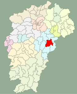 Location of Nancheng County (red) in Fuzhou City (light blue) and Jiangxi | |
| Coordinates: 27°34′11″N 116°38′13″E / 27.5697°N 116.6370°E | |
| Country | People's Republic of China |
| Province | Jiangxi |
| Prefecture-level city | Fuzhou |
| Established | 202 BCE |
| Area | |
| • Total | 1,698 km2 (656 sq mi) |
| Elevation | 70 m (230 ft) |
| Population (2019) | |
| • Total | 316,900 |
| • Density | 190/km2 (480/sq mi) |
| Time zone | UTC+8 (China Standard) |
| Postal code | 344700 |
| Area code | 0794 |
| Website | jxnc |
Nancheng (Chinese: 南城县; pinyin: Nánchéng; lit. 'south city') is a county of eastern Jiangxi province, People's Republic of China. It is under the jurisdiction of the prefecture-level city of Fuzhou. Historically it has been known as Jianchangfu (Kienchang) (建昌府).
Administrative divisions
In the present, Nancheng County has 9 towns and 3 townships.[1]
- 9 towns
|
|
- 3 townships
- Xujia (徐家乡)
- Tianjingyuan (天井源乡)
- Xunxi (浔溪乡)
Demographics

The population of the district was 287,466 in 1999.[2]
Climate
Nancheng County has a humid subtropical climate (Köppen Cfa), with long, humid, very hot summers and cool and drier winters with occasional cold snaps. The monthly 24-hour average temperature ranges from 6.0 °C (42.8 °F) in January to 29.1 °C (84.4 °F) in July, with an annual mean of 18.04 °C (64.5 °F); the frost-free period lasts 265 days.[3] The average annual precipitation is around 1,740 mm (69 in). Winter begins somewhat sunny and dry but becomes progressively wetter and cloudier; spring begins especially gloomy, and from March to June each of the months averages more than 190 mm (7.5 in) of rainfall. After the heavy rains subside in June, summer is especially sunny. Autumn is warm to mild and relatively dry. With monthly percent possible sunshine ranging from 20% in March to 58% in July, the county receives 1,635 hours of bright sunshine annually.
| Climate data for Nancheng County (1991–2020 normals, extremes 1971–2010) | |||||||||||||
|---|---|---|---|---|---|---|---|---|---|---|---|---|---|
| Month | Jan | Feb | Mar | Apr | May | Jun | Jul | Aug | Sep | Oct | Nov | Dec | Year |
| Record high °C (°F) | 27.5 (81.5) |
30.0 (86.0) |
31.8 (89.2) |
35.1 (95.2) |
35.7 (96.3) |
37.6 (99.7) |
40.2 (104.4) |
40.4 (104.7) |
38.2 (100.8) |
36.3 (97.3) |
31.9 (89.4) |
27.1 (80.8) |
40.4 (104.7) |
| Average high °C (°F) | 10.2 (50.4) |
13.5 (56.3) |
17.2 (63.0) |
23.5 (74.3) |
27.8 (82.0) |
30.3 (86.5) |
34.1 (93.4) |
33.5 (92.3) |
29.8 (85.6) |
24.9 (76.8) |
19.1 (66.4) |
12.9 (55.2) |
23.1 (73.5) |
| Daily mean °C (°F) | 6.3 (43.3) |
9.0 (48.2) |
12.7 (54.9) |
18.7 (65.7) |
23.2 (73.8) |
26.1 (79.0) |
29.2 (84.6) |
28.5 (83.3) |
25.1 (77.2) |
19.8 (67.6) |
14.1 (57.4) |
8.3 (46.9) |
18.4 (65.2) |
| Average low °C (°F) | 3.7 (38.7) |
6.0 (42.8) |
9.6 (49.3) |
15.3 (59.5) |
19.8 (67.6) |
23.2 (73.8) |
25.6 (78.1) |
25.2 (77.4) |
21.8 (71.2) |
16.2 (61.2) |
10.6 (51.1) |
5.0 (41.0) |
15.2 (59.3) |
| Record low °C (°F) | −6.2 (20.8) |
−7.3 (18.9) |
−2.9 (26.8) |
3.4 (38.1) |
10.1 (50.2) |
14.1 (57.4) |
19.3 (66.7) |
17.7 (63.9) |
13.5 (56.3) |
2.2 (36.0) |
−1.9 (28.6) |
−10.9 (12.4) |
−10.9 (12.4) |
| Average precipitation mm (inches) | 82.5 (3.25) |
100.3 (3.95) |
206.6 (8.13) |
220.4 (8.68) |
254.3 (10.01) |
341.0 (13.43) |
182.3 (7.18) |
134.9 (5.31) |
86.6 (3.41) |
57.2 (2.25) |
89.0 (3.50) |
65.3 (2.57) |
1,820.4 (71.67) |
| Average precipitation days (≥ 0.1 mm) | 13.7 | 13.5 | 18.3 | 17.8 | 17.3 | 16.9 | 10.9 | 12.2 | 9.0 | 7.8 | 9.8 | 10.3 | 157.5 |
| Average snowy days | 2.3 | 1.2 | 0.2 | 0 | 0 | 0 | 0 | 0 | 0 | 0 | 0 | 0.7 | 4.4 |
| Average relative humidity (%) | 81 | 80 | 82 | 79 | 79 | 82 | 74 | 77 | 79 | 78 | 79 | 78 | 79 |
| Mean monthly sunshine hours | 76.6 | 79.1 | 82.1 | 108.0 | 133.2 | 137.5 | 240.7 | 215.0 | 173.7 | 159.4 | 125.0 | 117.7 | 1,648 |
| Percent possible sunshine | 23 | 25 | 22 | 28 | 32 | 33 | 57 | 53 | 47 | 45 | 39 | 37 | 37 |
| Source 1: China Meteorological Administration[4][5] | |||||||||||||
| Source 2: Weather China[3] | |||||||||||||
Transportation
Notes and references
- ^ "南京市-行政区划网 www.xzqh.org" (in Chinese). XZQH. Retrieved 2012-05-24.
- ^ National Population Statistics Materials by County and City - 1999 Period, in China County & City Population 1999, Harvard China Historical GIS
- ^ a b 南城 - 气象数据 -中国天气网 (in Chinese (China)). Weather.com.cn. Retrieved 2011-12-29.
- ^ 中国气象数据网 – WeatherBk Data (in Simplified Chinese). China Meteorological Administration. Retrieved 28 June 2023.
- ^ 中国气象数据网 (in Simplified Chinese). China Meteorological Administration. Retrieved 28 June 2023.
External links
- (in Chinese) Government site - Google translation
- (in Chinese) Video of Nancheng
This Jiangxi location article is a stub. You can help Wikipedia by expanding it. |