
Nadowli-Kaleo District | |
|---|---|
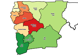 Districts of Upper West Region | |
 Nadowli-Kaleo District Location of Nadowli-Kaleo District within Upper West | |
| Coordinates: 10°22′26″N 2°40′26″W / 10.37389°N 2.67389°W | |
| Country | |
| Region | Upper West |
| Capital | Nadowli |
| Area | |
| • Total | 2,594 km2 (1,002 sq mi) |
| Population (2021) | |
| • Total | 77,057[1] |
| Time zone | UTC+0 (GMT) |
| ISO 3166 code | GH-UW-NK |
Nadowli-Kaleo District is one of the eleven districts in Upper West Region, Ghana.[2][3][4][5] Originally it was formerly part of the then-larger Nadowli District in 1988; until the eastern part of the district were later split off to create Daffiama-Bussie-Issa District on 28 June 2012; thus the remaining part has been renamed as Nadowli-Kaleo District. The district assembly is located in the northeast part of Upper West Region and has Nadowli as its capital town.
Economy
Agriculture is the most important economic sector of Nadowli District, accounting for about 85% of the labor force. The commercial and industrial sectors are less developed.
References
- ^ Ghana: Administrative Division
- ^ "New Districts & Nominated DCEs" (PDF). ghanadistricts. Archived from the original (PDF) on 5 March 2013.
- ^ "All Districts". ghanadistricts. Retrieved 8 June 2018.
- ^ "Districts of Ghana". statoids. Retrieved 8 June 2018.
- ^ "Work to start on 670-km feeder roads in Upper West". Graphic Online. Retrieved 2021-05-22.
| Municipal (5) |
|  |
|---|---|---|
| Ordinary (6) |
| |
10°22′26″N 2°40′26″W / 10.37389°N 2.67389°W