
North Carolina Highway 615 | ||||
|---|---|---|---|---|
 | ||||
| Route information | ||||
| Maintained by NCDOT | ||||
| Length | 14.9 mi[1] (24.0 km) | |||
| Existed | 1963–present | |||
| Major junctions | ||||
| South end | ||||
| North end | Princess Anne Road at the Virginia state line | |||
| Location | ||||
| Country | United States | |||
| State | North Carolina | |||
| Counties | Currituck | |||
| Highway system | ||||
| ||||

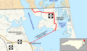
North Carolina Highway 615 (NC 615) is a primary state highway in the U.S. state of North Carolina. It connects Knotts Island with mainland North Carolina via the Currituck–Knotts Island Ferry.
Route description
NC 615 connects the community of Knotts Island with both mainland North Carolina and Virginia. The 14.9 miles (24.0 km) route begins at NC 168, in Currituck, where it goes east and crosses over the Currituck Sound, via the Currituck-Knotts Island Ferry. On Knotts Island, it continues north for nine miles (14 km) before reaching the Virginia state line. On the island, the route is well signed and borders the Mackay Island National Wildlife Refuge.
Ferry service, which predates the highway by one year (1962), was established originally to shorten the travel time for Knott's Island school children to their school on the mainland (in Barco). The ferry is free with year-round service with travel times of 45 minutes on average.[2]
The highway is the northeasternmost primary route in the state. The entire route is concurrent with North Carolina Bicycle Route 4.[3]
History
Established around 1963 as a new primary routing, NC 615 was located only on Knotts Island. At some point before 2001, the highway was extended overlapping the Currituck-Knotts Island Ferry, ending on the mainland at Courthouse Road.[citation needed] On April 9, 2013, it was extended .36 miles (0.58 km) northwest along Courthouse Road to end at its current southern terminus at NC 168. Justification for the extension was to connect to North Carolina Highway 168 and remove a gap.[4]
Major intersections
The entire route is in Currituck County.
| Location | mi[1] | km | Destinations | Notes | |
|---|---|---|---|---|---|
| Currituck | 0.0 | 0.0 | |||
| Currituck Sound | 0.4 | 0.64 | |||
| | 14.9 | 24.0 | Princess Anne Road | Virginia state line | |
| 1.000 mi = 1.609 km; 1.000 km = 0.621 mi | |||||
References
- ^ a b Google (June 14, 2013). "North Carolina Highway 615" (Map). Google Maps. Google. Retrieved June 14, 2013.
- ^ "NCDOT: Ferry Routes". Retrieved January 3, 2011.
- ^ "NC 4 - North Line Trace". North Carolina Bike Routes Beta. Walk Bike North Carolina Bicycle Routes. Retrieved March 11, 2016.
- ^ "NC 615 Route Change (2013-04-09)" (PDF). North Carolina Department of Transportation. April 9, 2013. Retrieved June 14, 2013.
External links
 Media related to North Carolina Highway 615 at Wikimedia Commons
- NCRoads.com: N.C. 615