
 | |
| Location | Musquash Head, New Brunswick, Canada |
|---|---|
| Coordinates | 45°08′37″N 66°14′14″W / 45.143628°N 66.237231°W |
| Tower | |
| Constructed | 1959 |
| Foundation | concrete base |
| Construction | concrete tower |
| Automated | 1980s |
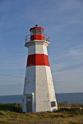
| Height | 14.3 m (47 ft) |
| Shape | octagonal tapered truncated tower with balcony and lantern[1] |
| Markings | white tower with a red horizontal band in the upper part, red lantern |
| Power source | solar power |
| Operator | Musquash Head Lightstation Inc.[2][3] |
| Fog signal | 4s. blast every 60s. |
| Light | |
| First lit | 1959 |
| Focal height | 35 m (115 ft) |
| Range | 20 nmi (37 km; 23 mi) |
| Characteristic | Fl W 3s |
| Original lighthouse | |
| Constructed | 1879 |
| Foundation | concrete base |
| Construction | wooden tower |
| Shape | square truncated tower rising from keeper’s house |
| Markings | white tower with a red horizontal band, red lantern |
| Deactivated | 1959 |
| Focal height | 34 m (112 ft) |
Musquash is a Canadian rural community in Saint John County, New Brunswick. It is located 5 km (3.1 mi) west southwest of the community of Prince of Wales in Musquash Parish.
YouTube Encyclopedic
-
1/1Views:575
-
West branch musquash dam
Transcription
History
Musquash was settled in the early 1800s at the head of navigation on the Musquash River. The Shore Line Railway (later Canadian Pacific Railway) was built through the community but has since been abandoned. The community includes the locales of Ivanhoe, West Musquash and Clinch's Mills. A post office was located in Musquash from 1847 to 1969. It was largely a farming and lumbering community but is now largely an exurb of Saint John, thanks to being located on the Route 1 expressway.
Notable people
See also
References
- ^ List of Lights, Pub. 110: Greenland, The East Coasts of North and South America (Excluding Continental U.S.A. Except the East Coast of Florida) and the West Indies (PDF). List of Lights. United States National Geospatial-Intelligence Agency. 2015.
- ^ Rowlett, Russ. "Lighthouses of Canada: Southern New Brunswick". The Lighthouse Directory. University of North Carolina at Chapel Hill. Retrieved 2017-03-25.
- ^ Musquash Head, NB Lighthouse Friends. Retrieved 25 March 2017
External links
- Provincial Archives of New Brunswick - Musquash
- Natural Resources Canada - Musquash
- Picture of the lighthouse
- Aids to Navigation Canadian Coast Guard
45°11′35″N 66°19′47″W / 45.19306°N 66.32972°W
| National | |
|---|---|
| Musquash Head Lighthouse | |
This New Brunswick location article is a stub. You can help Wikipedia by expanding it. |