
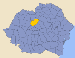
Mureș County
Județul Mures Maros megye | |
|---|---|
 | |
 Coat of arms | |
 | |
| Coordinates: 46°35′N 24°37′E / 46.59°N 24.61°E | |
| Country | |
| Development region1 | Centru |
| Historic region | Transylvania |
| County seat | Târgu Mureș |
| Government | |
| • Type | County Board |
| • President of the County Board | Ferenc Péter |
| • Prefect2 | Mircea Dușa |
| Area | |
| • Total | 6,714 km2 (2,592 sq mi) |
| • Rank | 11th in Romania |
| Population (2021-12-01)[1] | |
| • Total | 518,193 |
| • Rank | 12th in Romania |
| • Density | 82/km2 (210/sq mi) |
| Time zone | UTC+2 (EET) |
| • Summer (DST) | UTC+3 (EEST) |
| Postal Code | 54wxyz3 |
| Area code | +40 x654 |
| Car plates | MS5 |
| GDP (nominal) | US$ 8.120 billion (204) |
| GDP per capita | US$ 7,068 (2015) |
| Website | County Board County Prefecture |
| 1The developing regions of Romania have no administrative role. 2 as of 2007, the Prefect is not a politician, but a public functionary. He (or she) is not allowed to be a member of a political party, and is banned to have any political activity in the first six months after the resignation (or exclusion) from the public functionary corps 3w, x, y, and z are digits that indicate the city, the street, part of the street, or even the building of the address 4x is a digit indicating the operator: 2 for the former national operator, Romtelecom, and 3 for the other ground telephone networks 5used on both the plates of the vehicles that operate only in the county limits (like utility vehicles, ATVs, etc.), and the ones used outside the county | |
Mureș County (Romanian pronunciation: [ˈmureʃ], Romanian: Județul Mures, Hungarian: Maros megye) is a county (județ) of Romania, in the historical region of Transylvania, with the administrative centre in Târgu Mureș. The county was established in 1968, after the administrative reorganization that re-introduced the historical județ (county) system, still used today. This reform eliminated the previous Mureș-Magyar Autonomous Region, which had been created in 1952 within the People's Republic of Romania. Mureș County has a vibrant multicultural fabric that includes Hungarian-speaking Székelys and Transylvanian Saxons, with a rich heritage of fortified churches and towns.
Name
In Hungarian, it is known as Maros megye ([ˈmɒroʃ ˈmɛɟɛ]), and in German as Kreis Mieresch. Under Kingdom of Hungary, a county with a similar name (Maros-Torda County, Romanian: Comitatul Mureş-Turda) was created in 1876. There was a county with the same name under the Kingdom of Romania, and a Mureș-Magyar Autonomous Region (1960–1968) under the Socialist Republic of Romania.
Geography
The county has a total area of 6,714 km2 (2,592 sq mi).
The northeastern side of the county consists of the Călimani and Gurghiu Mountains and the sub-Carpathian hills, members of the Inner Eastern Carpathians. The rest of the county is part of the Transylvanian Plateau, with deep but wide valleys.
The main river crossing in the county is the Mureș River. The Târnava Mare River and the Târnava Mică River also cross the county.
Mureș County is bordered by seven other counties: Suceava, Harghita, Brașov, Sibiu, Alba, Cluj and Bistrița-Năsăud.
Neighbours

- Harghita County in the East.
- Alba County and Cluj County in the West.
- Bistrița-Năsăud County and Suceava County in the North.
- Sibiu County and Brașov County in the South.
Demographics


In 2011, Mureș had a population of 550,846 and the population density was 82 inhabitants per square kilometre (210/sq mi).[2][3]
| Ethnic structure (2002) | |||||||||||||
|---|---|---|---|---|---|---|---|---|---|---|---|---|---|
| Total | Romanians | Hungarians | Roma | Germans | Other | ||||||||
| 580,851 | 309,375 | 228,275 | 40,425 | 2,045 | 731 | ||||||||
| 100% | 53.26% | 39.30% | 6.96% | 0.35% | 0.12% | ||||||||
| Ethnic structure (2011) | |||||||||||||
|---|---|---|---|---|---|---|---|---|---|---|---|---|---|
| Total | Romanians | Hungarians | Roma | Germans | Other | ||||||||
| 550,846 | 277,372 | 200,858 | 46,947 | 1,478 | 792 | ||||||||
| 100% | 52.60% | 38.09% | 8.90% | 0.28% | 0.13% | ||||||||
| Ethnic structure (2021) | |||||||||||||
|---|---|---|---|---|---|---|---|---|---|---|---|---|---|
| Total | Romanians | Hungarians | Roma | Germans | Other | ||||||||
| 518,193 | 252,400 | 165,014 | 44,880 | 904 | 617 | ||||||||
| 100% | 54.42% | 35.58% | 9.68% | 0.19% | 0.13% | ||||||||
In terms of religion:
- Romanian Orthodox – 53.3%
- Reformed Church – 27%
- Roman Catholic Church – 9.5%
- Other Christian denominations – 8.2%
- Jewish, Muslim, Atheist, Non-religious, other, or undeclared – 1.9%

| Year | Pop. | ±% p.a. |
|---|---|---|
| 1930 | 425,721 | — |
| 1948 | 461,403 | +0.45% |
| 1956 | 513,261 | +1.34% |
| 1966 | 561,598 | +0.90% |
| 1977 | 605,345 | +0.68% |
| 1992 | 607,298 | +0.02% |
| 2002 | 580,851 | −0.44% |
| 2011 | 550,846 | −0.59% |
| 2021 | 518,193 | −0.61% |
Tourism
Some of the main tourist attractions in the county are:
- The old city of Târgu Mureș
- The medieval city of Sighișoara
- Sovata resort
- The city of Reghin
- The medieval fortified church of Saschiz
- Călimani Mountains – Gurghiu Mountains
- The Via Transilvanica long-distance hiking and biking trail, which crosses the county
Media
TV stations
| Channel | Name | Network | Launch date | Notes |
|---|---|---|---|---|
| 1 | TVR 1 | Romanian Public Television | 1956 | Public channel |
| 2 | TVR 2 | Romanian Public Television | 1968 (hiatus 1985–1990) | Public channel |
| 3 | Pro TV Târgu-Mureș | Pro TV | 1997 | Affiliated stadion |
| 4 | Antena 1 Târgu-Mureș | Antena 1 | 1998 | Affiliated stadion |
| 5 | Prima TV Târgu-Mureș | Prima TV | 2008 | Affiliated station |
| 26 | TTM | None | 2006 | Local news channel |
| 25 | Știi TV | None | 2008 | Local news channel |
| 57 | DIGI24 HD Cluj-Napoca | RCS&RDS | 2013 | Regional news channel |
| 63 | TVR Târgu-Mureș | Romanian Public Television | 2008 | Regional station |
| Gliga TV Reghin | Gliga CATV | 2001 | Local news channel in Reghin | |
| DaReghin | None | 2009 | Local news channel in Reghin | |
| Târnava TV | None | 2008 | Local news channel in Sighișoara and Târnăveni |
The only cable provider in Târgu-Mureș is RCS&RDS, in Reghin is Gliga CATV, and in Sighișoara Teleson .
Radio stations
Târgu-Mureș stations
| Frequency | Name | Launch date | Format | Notes |
|---|---|---|---|---|
| FM 102.9 | Radio România Târgu-Mureș | 1958 | Public / news – music | Regional station |
| FM 89.1 | PRO FM | 1997 | Commercial radio | Bucharest |
| FM 90.3 | Kiss FM | 2003 | Commercial radio | Bucharest |
| FM 90.7 | Europa FM | 2002 | Commercial radio | Bucharest |
| FM 88 | Eadio GaGa | 1994 | ||
| FM 88.4 | Rock FM | 1997 | Bucharest | |
| FM 92.7 | Radio 21 | 2002 | Bucharest | |
| FM 93.6 | Radio România Actualități | 1928 | Bucharest | |
| FM 97.1 | Erdély FM | 2007 | ||
| FM 98 | Radio Zu | 2008 | Bucharest | |
| FM 100.6 | Național FM | 2004 | Oradea | |
| FM 101.2 | Magic FM | 2000 | Bucharest | |
| FM 101.6 | Radio InfoPRO | 2005 | Bucharest | |
| FM 105.6 | Radio SON | 2007 | Sighișoara |
Newspapers and magazines
- Cuvântul Liber
- Zi de Zi
- Ziarul de Mureș
- Népújság
- Krónika
- Vásárhelyi Hírlap
Economy
The predominant industries in the county are:
- Wood industry.
- Food industry.
- Textile industry.
- Glass and ceramics industry.
- Construction materials.
- Musical instruments (Reghin).
Mureș County and Sibiu County together produce about 50% of the natural gas developed in Romania. Salt is also extracted in the county.
Politics
The Mureș County Council, renewed at the 2020 local elections, consists of 34 counsellors, with the following party composition:[4]
| Party | Seats | Current Council | ||||||||||||||||
|---|---|---|---|---|---|---|---|---|---|---|---|---|---|---|---|---|---|---|
| Democratic Alliance of Hungarians (UDMR/RMDSZ) | 16 | |||||||||||||||||
| National Liberal Party (PNL) | 9 | |||||||||||||||||
| Social Democratic Party (PSD) | 7 | |||||||||||||||||
| People's Movement Party (PMP) | 2 | |||||||||||||||||
Administrative divisions


Mureș County has 4 municipalities, 7 towns and 91 communes.
- Municipalities
- Târgu Mureș – county seat; population: 134,290 (as of 2011)
- Reghin
- Sighișoara
- Târnăveni
- Towns
- Communes
- Acățari
- Adămuș
- Albești
- Aluniș
- Apold
- Ațintiș
- Bahnea
- Band
- Batoș
- Băgaciu
- Băla
- Bălăușeri
- Beica de Jos
- Bereni
- Bichiș
- Bogata
- Brâncovenești
- Breaza
- Ceuașu de Câmpie
- Chețani
- Chibed
- Chiheru de Jos
- Coroisânmărtin
- Corunca
- Cozma
- Crăciunești
- Cucerdea
- Crăiești
- Cristești
- Cuci
- Daneș
- Deda
- Eremitu
- Ernei
- Fântânele
- Fărăgău
- Gălești
- Gănești
- Gheorghe Doja
- Ghindari
- Glodeni
- Gornești
- Grebenișu de Câmpie
- Gurghiu
- Hodac
- Hodoșa
- Ibănești
- Iclănzel
- Ideciu de Jos
- Livezeni
- Lunca
- Lunca Bradului
- Mădăraș
- Măgherani
- Mica
- Miheșu de Câmpie
- Nadeș
- Neaua
- Ogra
- Papiu Ilarian
- Pănet
- Păsăreni
- Petelea
- Pogăceaua
- Râciu
- Răstolița
- Rușii-Munți
- Sâncraiu de Mureș
- Sângeorgiu de Mureș
- Sânger
- Sânpaul
- Sânpetru de Câmpie
- Sântana de Mureș
- Sărățeni
- Saschiz
- Solovăstru
- Stânceni
- Suplac
- Suseni
- Șăulia
- Șincai
- Tăureni
- Valea Largă
- Vânători
- Vărgata
- Vătava
- Vețca
- Viișoara
- Voivodeni
- Zagăr
- Zau de Câmpie
Historical county
Județul Mureș | |
|---|---|
County (Județ) | |
 The Mureș County Prefecture building of the interwar period. | |
 Coat of arms | |
 | |
| Country | |
| Historic region | Transylvania |
| Capital city (Reședință de județ) | Târgu Mureș |
| Established | 1925 |
| Area | |
| • Total | 4,856 km2 (1,875 sq mi) |
| Population (1930) | |
| • Total | 289,456 |
| • Density | 60/km2 (150/sq mi) |
| Time zone | UTC+2 (EET) |
| • Summer (DST) | UTC+3 (EEST) |
Historically, Mureş-Turda County was located in the central-northern part of Greater Romania, in the central part of Transylvania. The capital was Târgu Mureș. After the administrative unification law in 1925, it was renamed to Mureș County, and the territory was reorganized. It was bordered on the south by Târnava-Mică County, on the southwest by Turda County, on the west by Cluj County, on the north by Năsăud County, on the northeast with the counties of Câmpulung and Neamț, and on the southeast with the counties of Ciuc and Odorhei. Most of the territory of the historical county is found in the present Mureș County, except for the northeastern area, which is located in Harghita County, and the northwestern area in Bistrița-Năsăud County today.
History
Prior to World War I, the territory of the county belonged to Austria-Hungary and identical with the Maros-Torda County of the Kingdom of Hungary. The territory of Mureș County was transferred to Romania from Hungary as successor state to Austria-Hungary in 1920 under the Treaty of Trianon.
In 1938, King Carol II promulgated a new Constitution, and subsequently he had the administrative division of the Romanian territory changed. 10 ținuturi (approximate translation: "lands") were created (by merging the counties) to be ruled by rezidenți regali (approximate translation: "Royal Residents") – appointed directly by the King – instead of the prefects. Mureș County became part of Ținutul Mureș.
In 1940, the county was transferred back to Hungary with the rest of Northern Transylvania under the Second Vienna Award. Beginning in 1944, Romanian forces with Soviet assistance recaptured the ceded territory and reintegrated it into Romania, re-establishing the county. Romanian jurisdiction over the entire county per the Treaty of Trianon was reaffirmed in the Paris Peace Treaties, 1947. The county was disestablished by the communist government of Romania in 1950, and re-established in 1968 when Romania restored the county administrative system.
Administration

The county originally consisted of seven districts (plăși):[5]
- Plasa Band, headquartered at Band
- Plasa Miercurea Nirajului, headquartered at Miercurea Nirajului
- Plasa Râciu, headquartered at Râciu
- Plasa Reghin, headquartered at Reghin
- Plasa Târgu Mureș (also called Plasa Mureș), headquartered at Târgu Mureș
- Plasa Teaca, headquartered at Teaca
- Plasa Toplița, headquartered at Toplița
A subsequent administrative adjustment added one district, divided Plasa Mureș into two, and divided Plasa Reghin into two, leaving ten districts:
- Plasa Band, headquartered at Band
- Plasa Gurhiu, headquartered at Gurghiu
- Plasa Miercurea Nirajului, headquartered at Miercurea Nirajului
- Plasa Mureș de Jos, headquartered at Mureșeni
- Plasa Mureș de Sus, headquartered at Târgu Mureș
- Plasa Râciu, headquartered at Râciu
- Plasa Reghin de Jos, headquartered at Reghin
- Plasa Reghin de Sus, headquartered at Suseni
- Plasa Teaca, headquartered at Teaca
- Plasa Toplița, headquartered at Toplița
The county had two urban localities: Târgu Mureş (a city) and Reghin (urban commune).
Population
According to the census data of 1930, the county's population was 289,546, of which 45.8% were Romanians, 42.6% Hungarians, 3.9% Germans, 3.9% Romanies, 3.4% Jews, as well as other minorities. By mother tongue, the county population consisted of 45.9% Hungarian speakers, 45.5% Romanian speakers, 3.9% German speakers, 2.2% Yiddish speakers, and 2.1% Romany speakers.[6] In the religious aspect, the population consisted of 32.4% Greek Catholic, 30.3% Reformed, 14.5% Eastern Orthodox, 12.1% Roman Catholic, 3.9% Lutheran, 3.6% Jewish, 2.6% Unitarian, as well as other minorities.[7]
Urban population
In 1930, the urban population of the county was 47,807, of which 54.3% were Hungarians, 24.3% Romanians, 13.4% Jews, 6.0% Germans, 1.1% Romanies, as well as other minorities. As a mother tongue in the urban population, Hungarian was spoken by 61.2% of the population, followed by Romanian, spoken by 23.6% of the population as mother tongue, Yiddish (7.4%) and German (6.2%). From the religious point of view, the urban population was made up of 32.6% Reformed, 20.1% Roman Catholic, 14.2% Greek Catholic, 14.2% Jewish, 10% Eastern Orthodox, 5.9% Lutheran, 2.3% Unitarian, as well as other minorities.[7]
References
- ^ "Populaţia rezidentă după grupa de vârstă, pe județe și municipii, orașe, comune, la 1 decembrie 2021" (XLS). National Institute of Statistics.
- ^ "Population at 20 October 2011" (in Romanian). INSSE. 5 July 2013. Retrieved 9 July 2013.
- ^ National Institute of Statistics, "Populaţia după etnie" Archived 16 August 2009 at the Wayback Machine ("Population by ethnicity")
- ^ "Rezultatele finale ale alegerilor locale din 2020" (Json) (in Romanian). Autoritatea Electorală Permanentă. Retrieved 2 November 2020.
- ^ Portretul României Interbelice – Județul Mureș
- ^ Recensământul general al populației României din 29 decemvrie 1930, Vol. II, pag. 290-297
- ^ a b Recensământul general al populației României din 29 decemvrie 1930, Vol. II, pag. 666-669
External links
- (in Hungarian) Euro Maros
- (in Hungarian) Mediatica News
- (in Romanian) Mureş Info
- (in Romanian and Hungarian) Mureş online
Media

| National | |
|---|---|
| Geographic | |