
Mueang Narathiwat
เมืองนราธิวาส | |
|---|---|
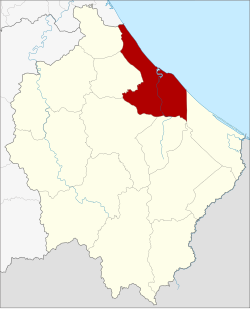 District location in Narathiwat province | |
| Coordinates: 6°25′34″N 101°49′23″E / 6.42611°N 101.82306°E | |
| Country | Thailand |
| Province | Narathiwat |
| Seat | Bang Nak |
| Area | |
| • Total | 305.115 km2 (117.806 sq mi) |
| Population (2005) | |
| • Total | 108,644 |
| • Density | 356.1/km2 (922/sq mi) |
| Time zone | UTC+7 (ICT) |
| Postal code | 96000 |
| Geocode | 9601 |
Mueang Narathiwat (Thai: เมืองนราธิวาส, pronounced [mɯ̄a̯ŋ nā.rāː.tʰí.wâːt]) is the capital district (amphoe mueang) of Narathiwat province, southern Thailand.
History
The area of Mueang Narathiwat was originally a village named Menara (เมอนารา or เมอนารอ), under Mueang Sai Buri. Later it was upgraded to a tambon and changed to be controlled by Mueang Ra-ngae. Tambon Manalo grew bigger, so the government moved the city hall from Tambon Tanyong Mat to Manalo. Then they upgraded Tambon Manalo to Mueang Bang Nara. King Vajiravudh (Rama VI) renamed the city Narathiwat in 1915,[1] however in 1917 the district was renamed from Mueang to the old name, Bang Nara.[2] In 1938 the district name was changed to Mueang Narathiwat District.[3]
Geography
Neighboring districts are (from the southeast clockwise): Tak Bai, Cho-airong, Ra-ngae, Yi-ngo, and Bacho of Narathiwat Province; Mai Kaen of Pattani province and the Gulf of Thailand.
The important water resource is the Bang Nara River.
Ao Manao-Khao Tanyong National Park is in the district.
Administration
The district is divided into seven sub-districts (tambons), which are further subdivided into 57 villages (mubans). The town (thesaban mueang) Narathiwat covers parts of tambon Bang Nak. The six remaining tambons are each led by a tambon administrative organization (TAO).
| No. | Name | Thai name | Villages | Pop. |
|---|---|---|---|---|
| 1. | Bang Nak | บางนาค | - | 40,406 |
| 2. | Lamphu | ลำภู | 11 | 10,543 |
| 3. | Manang Tayo | มะนังตายอ | 7 | 7,721 |
| 4. | Bang Po | บางปอ | 8 | 9,844 |
| 5. | Kaluwo | กะลุวอ | 7 | 8,382 |
| 6. | Kaluwo Nuea | กะลุวอเหนือ | 12 | 13,575 |
| 7. | Khok Khian | โคกเคียน | 12 | 18,173 |
References
- ^ ประกาศ เปลี่ยนชื่อเมืองบางนรา เป็นเมืองนราธิวาส (PDF). Royal Gazette (in Thai). 32 (ก): 145. 8 August 1915. Archived from the original (PDF) on 9 April 2008.
- ^ ประกาศกระทรวงมหาดไทย เรื่อง เปลี่ยนชื่ออำเภอ (PDF). Royal Gazette (in Thai). 34 (ก): 40–68. 29 April 1917. Archived from the original (PDF) on 7 November 2011.
- ^ พระราชกฤษฎีกาเปลี่ยนนามจังหวัด และอำเภอบางแห่ง พุทธศักราช ๒๔๘๑ (PDF). Royal Gazette (in Thai). 55 (ก): 658–666. 14 November 1938. Archived from the original (PDF) on 8 November 2011.
External links
This Narathiwat Province location article is a stub. You can help Wikipedia by expanding it. |