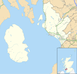
55°32′31″N 5°19′46″W / 55.541887°N 5.329363°W
 Moss Farm Road Stone Circle | |
Shown within the Isle of Arran, Scotland | |
| Location | Isle of Arran |
|---|---|
| Coordinates | 55°32′31″N 5°19′46″W / 55.541887°N 5.329363°W |
| Type | Kerbed burial cairn |
| History | |
| Periods | Bronze Age |
| Site notes | |
| Ownership | Historic Scotland |
| Public access | Yes |
Moss Farm Road Stone Circle (or Machrie Moor 10) is the remains of a Bronze Age burial cairn, surrounded by a circle of stones. It is located near Machrie on the Isle of Arran in Scotland (grid reference NR90063265).
YouTube Encyclopedic
-
1/3Views:730521610
-
Lake District Country Walk St John's in the Vale Castlerigg Stone Circle and Low Rigg round
-
Castlerigg stone circle - Cumbria - Britain
-
Stonehenge - A New Visitor Experience
Transcription
Description
The cairn and stone circle is situated 3 miles north of Blackwaterfoot on the west side of the Isle of Arran.[1] Around 1 kilometre to the east are the Machrie Moor Stone Circles, and this circle is sometimes known as Machrie Moor Circle 10.[2]
The cairn has been robbed for stone, and a modern fence and a farm track have cut through the north side of the site.[3] It was once surrounded by a complete circle of stones with a diameter of 23 metres, but many have been removed. The kerb now consists of seven upright stones, around 1 metre high with at least five more large stones now on edge.[3]
References
- ^ Moss Farm Road Stone Circle, Historic Scotland, accessed 1 May 2014
- ^ Burl, Aubrey (2005). A Guide to the Stone Circles of Britain, Ireland and Brittany. Yale University Press. p. 114. ISBN 0300114060.
- ^ a b Historic Environment Scotland. "Moss Farm Road, Arran (39726)". Canmore. Retrieved 1 May 2014.
External links
![]() Media related to Moss Farm Road Stone Circle at Wikimedia Commons
Media related to Moss Farm Road Stone Circle at Wikimedia Commons

