To install click the Add extension button. That's it.

The source code for the WIKI 2 extension is being checked by specialists of the Mozilla Foundation, Google, and Apple. You could also do it yourself at any point in time.

4,5
Kelly Slayton
Congratulations on this excellent venture… what a great idea!
Alexander Grigorievskiy
I use WIKI 2 every day and almost forgot how the original Wikipedia looks like.
What we do. Every page goes through several hundred of perfecting techniques; in live mode. Quite the same Wikipedia. Just better.
.
Leo
Newton
Brights
Milds

From Wikipedia, the free encyclopedia

Mixdorf
Coat of arms of Mixdorf
Location of Mixdorf within Oder-Spree district
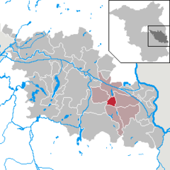
Bad SaarowBeeskowBerkenbrückBriesenBrieskow-FinkenheerdDiensdorf-RadlowEisenhüttenstadtErknerFriedlandFürstenwaldeGosen-Neu ZittauGroß LindowGrünheideGrunow-DammendorfJacobsdorfLangewahlLawitzBriesen (Mark)MixdorfMüllroseNeißemündeNeuzelleRagow-MerzRauenReichenwaldeRietz-NeuendorfSchlaubetalSchöneicheSiehdichumSpreenhagenSteinhöfelStorkowTaucheVogelsangWendisch RietzWiesenauWoltersdorfZiltendorfBrandenburg
Mixdorf is located in Germany
Mixdorf
Mixdorf
Mixdorf is located in Brandenburg
Mixdorf
Mixdorf
Coordinates: 52°12′N 14°24′E / 52.200°N 14.400°E / 52.200; 14.400
CountryGermany
StateBrandenburg
DistrictOder-Spree  
Municipal assoc.Schlaubetal
Government
 • Mayor (2019–24) Dieter-Lothar Mutke[1]
Area
 • Total13.03 km2 (5.03 sq mi)
Elevation
61 m (200 ft)
Population
 (2022-12-31)[2]
 • Total924
 • Density71/km2 (180/sq mi)
Time zoneUTC+01:00 (CET)
 • Summer (DST)UTC+02:00 (CEST)
Postal codes
15299
Dialling codes033655
Vehicle registrationLOS

Mixdorf is a municipality in the Oder-Spree district, in Brandenburg, Germany.

YouTube Encyclopedic

  • 1/2
    Views:
    2 446
    987
  • CABO BRANCO LIGHTHOUSE - BRAZIL
  • Asia Slide Show - Nature

Transcription

History

From 1815 to 1947, Mixdorf was part of the Prussian Province of Brandenburg.

After World War II, Mixdorf was incorporated into the State of Brandenburg from 1947 to 1952 and the Bezirk Frankfurt of East Germany from 1952 to 1990. Since 1990, Mixdorf is again part of Brandenburg.
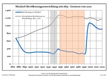
Demography

Development of Population since 1875 within the Current Boundaries (Blue Line: Population; Dotted Line: Comparison to Population Development of Brandenburg state; Grey Background: Time of Nazi rule; Red Background: Time of Communist rule)
Mixdorf: Population development
within the current boundaries (2020)[3]
YearPop.±% p.a.
1875 670—    
1890 317−4.87%
1910 312−0.08%
1925 307−0.11%
1933 288−0.80%
1939 268−1.19%
1946 388+5.43%
1950 360−1.86%
1964 316−0.93%
1971 313−0.14%
1981 263−1.73%
1985 279+1.49%
1989 265−1.28%
1990 262−1.13%
1991 259−1.15%
1992 277+6.95%
1993 389+40.43%
1994 634+62.98%
1995 838+32.18%
1996 958+14.32%
1997 1,032+7.72%
1998 1,063+3.00%
YearPop.±% p.a.
1999 1,074+1.03%
2000 1,060−1.30%
2001 1,055−0.47%
2002 1,051−0.38%
2003 1,043−0.76%
2004 1,037−0.58%
2005 1,020−1.64%
2006 1,009−1.08%
2007 993−1.59%
2008 972−2.11%
2009 958−1.44%
2010 955−0.31%
2011 940−1.57%
2012 927−1.38%
2013 914−1.40%
2014 917+0.33%
2015 906−1.20%
2016 912+0.66%
2017 907−0.55%
2018 908+0.11%
2019 902−0.66%
2020 914+1.33%

References

  1. ^ Landkreis Oder-Spree Wahl der Bürgermeisterin / des Bürgermeisters, accessed 2 July 2021.
  2. ^ "Bevölkerungsentwicklung und Bevölkerungsstandim Land Brandenburg Dezember 2022" (PDF). Amt für Statistik Berlin-Brandenburg (in German). June 2023.
  3. ^ Detailed data sources are to be found in the Wikimedia Commons.Population Projection Brandenburg at Wikimedia Commons
This page was last edited on 8 July 2023, at 17:01
Basis of this page is in Wikipedia. Text is available under the CC BY-SA 3.0 Unported License. Non-text media are available under their specified licenses. Wikipedia® is a registered trademark of the Wikimedia Foundation, Inc. WIKI 2 is an independent company and has no affiliation with Wikimedia Foundation.