
Native name: 南大東島 Minamidaitō-jima | |
|---|---|
 Aerial Photograph of Minamidaitōjima | |
 | |
| Geography | |
| Location | Philippine Sea |
| Coordinates | 25°50′N 131°14′E / 25.833°N 131.233°E |
| Archipelago | Daitō Islands |
| Area | 30.57 km2 (11.80 sq mi) |
| Length | 4.85 km (3.014 mi) |
| Coastline | 18.3 km (11.37 mi) |
| Highest elevation | 75 m (246 ft) |
| Administration | |
Japan | |
| Prefectures | Okinawa Prefecture |
| District | Shimajiri District |
| Village | Minamidaitō |
| Demographics | |
| Population | 2,107[1] (2010) |
| Ethnic groups | Ryukyuan, Japanese |

Minamidaitōjima (南大東島), also spelt as Minami Daitō or Minami-Daitō, is the largest island in the Daitō Islands group southeast of Okinawa, Japan. It is administered as part of the village of Minamidaitō, Okinawa. Shimajiri District, Okinawa and has a population of 2,107.[1] The island is entirely cultivated for agriculture. The island has no beaches but has a fishing boat harbor and three cargo and ferry ports; as well as an airport Minami Daito Airport (airport code "MMD").
YouTube Encyclopedic
-
1/3Views:7881 3371 116
-
USS Indiana (BB-58) Bombards Okinawa, 05/09/1945 (full)
-
9/11/2011 BB-59 21 gun salute, 9/11 Memorial Ceremony
-
Hurricane & Resultant Damage Aboard USS Indiana (BB-58), 06/05/1945 (full)
Transcription
Geography
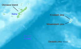
Minamidaitōjima is a relatively isolated coralline island, located approximately 9 kilometres (4.9 nmi) south of Kitadaitōjima, the second largest island of the archipelago, and 360 kilometres (190 nmi) from Naha, Okinawa. As with the other islands in the archipelago, Minamidaitōjima is an uplifted coral atoll with a steep coastal cliff of limestone (the former fringing coral reef of the island), and a depressed center (the former lagoon of the island). The island is roughly oval in shape, with a circumference of about 13.52 kilometres (8.40 mi), length of 4.85 kilometres (3.01 mi) and an area of 11.94 square kilometres (4.61 sq mi). The highest point is 74 metres (243 ft) above sea level. The island contains several ponds in the interior, such as the Ōike-pond.
- Gallery
-
 Minamidaitōjima
 -
 Minamidaitojima coast surrounded by cliffs
 -
 A lake on the island
Climate
Minamidaitōjima has a tropical rainforest climate (Köppen climate classification Af) with hot summers and warm winters. Precipitation is significant throughout the year; the wettest month is June and the driest month is February. The island is subject to frequent typhoons.
| Climate data for Minamidaitō (1991−2020 normals, extremes 1942−present) | |||||||||||||
|---|---|---|---|---|---|---|---|---|---|---|---|---|---|
| Month | Jan | Feb | Mar | Apr | May | Jun | Jul | Aug | Sep | Oct | Nov | Dec | Year |
| Record high °C (°F) | 26.8 (80.2) |
27.0 (80.6) |
28.1 (82.6) |
30.2 (86.4) |
31.9 (89.4) |
34.1 (93.4) |
35.3 (95.5) |
34.6 (94.3) |
34.0 (93.2) |
33.0 (91.4) |
30.8 (87.4) |
28.3 (82.9) |
35.3 (95.5) |
| Mean daily maximum °C (°F) | 21.1 (70.0) |
21.2 (70.2) |
22.6 (72.7) |
24.6 (76.3) |
26.9 (80.4) |
29.6 (85.3) |
31.7 (89.1) |
31.6 (88.9) |
31.0 (87.8) |
28.8 (83.8) |
25.8 (78.4) |
22.6 (72.7) |
26.5 (79.6) |
| Daily mean °C (°F) | 18.0 (64.4) |
18.1 (64.6) |
19.5 (67.1) |
21.6 (70.9) |
24.1 (75.4) |
26.9 (80.4) |
28.7 (83.7) |
28.6 (83.5) |
27.9 (82.2) |
25.9 (78.6) |
23.1 (73.6) |
19.7 (67.5) |
23.5 (74.3) |
| Mean daily minimum °C (°F) | 14.6 (58.3) |
14.8 (58.6) |
16.4 (61.5) |
18.8 (65.8) |
21.5 (70.7) |
24.8 (76.6) |
25.9 (78.6) |
25.9 (78.6) |
25.0 (77.0) |
23.0 (73.4) |
20.4 (68.7) |
16.6 (61.9) |
20.6 (69.1) |
| Record low °C (°F) | 3.5 (38.3) |
4.3 (39.7) |
5.3 (41.5) |
4.7 (40.5) |
10.6 (51.1) |
14.6 (58.3) |
19.4 (66.9) |
19.7 (67.5) |
16.1 (61.0) |
12.9 (55.2) |
9.8 (49.6) |
6.4 (43.5) |
3.5 (38.3) |
| Average precipitation mm (inches) | 77.0 (3.03) |
79.9 (3.15) |
84.2 (3.31) |
113.6 (4.47) |
222.0 (8.74) |
199.6 (7.86) |
118.0 (4.65) |
151.1 (5.95) |
167.9 (6.61) |
180.5 (7.11) |
120.9 (4.76) |
124.7 (4.91) |
1,639.3 (64.54) |
| Average precipitation days (≥ 1.0 mm) | 8.4 | 7.8 | 7.3 | 8.0 | 10.6 | 9.4 | 8.1 | 10.5 | 10.7 | 10.4 | 8.6 | 8.7 | 108.5 |
| Average relative humidity (%) | 69 | 71 | 74 | 78 | 84 | 87 | 81 | 81 | 80 | 77 | 74 | 70 | 77 |
| Mean monthly sunshine hours | 121.3 | 120.3 | 154.0 | 152.8 | 171.0 | 219.3 | 277.8 | 249.3 | 220.4 | 178.4 | 136.4 | 120.8 | 2,121.7 |
| Source: Japan Meteorological Agency[2][3] | |||||||||||||
History
It is uncertain when Minamidaitōjima was discovered. It is the most likely that their first sighting was by the Spanish navigator Bernardo de la Torre in 1543, in between 25 September and 2 October, during his abortive attempt to reach New Spain from the Philippines with the San Juan de Letrán. It was then charted, together with Kitadaitōjima, as "The Two Sisters" (Las Dos Hermanas). There is little doubt that Minamidaitōjima and Kitadaitōjima were again sighted by the Spanish on 28 July 1587, by Pedro de Unamuno who named them the "Useless Islands" (Islas sin Provecho).[4] In 1788 the British captain John Meares named an island in the vicinity “Grampus Island”, but the recorded coordinates are not correct and it is not certain which of the Daitō island he sighted[citation needed]. The French also reported sighting an island in 1807[citation needed]. However, on 2 July 1820 the Russian vessel Borodino surveyed the two Daitō islands, and named the south as "South Borodino Island".
The island remained uninhabited until claimed by the Empire of Japan in 1885. In 1900, a team of pioneers from Hachijōjima, one of the Izu Islands located 287 kilometres (178 mi) south of Tokyo led by Tamaoki Han'emon (1838 – 1910), became the first human inhabitants of the island, and started the cultivation of sugar cane. The population reached 4000 in 1919. During this period until World War II, Minamidaitōjima was owned in its entirety by Dai Nippon Sugar (now Dai Nippon Meiji Sugar), which provided community services and subsidized pricing for its employees, and of whom were seasonal workers from Okinawa and Taiwan.
The island was garrisoned by the Japanese military in 1942. As the war situation worsened for Japan, many of the civilian inhabitants were evacuated to Okinawa, Kyushu or Hachijojima in 1944. The island was repeatedly bombed and shelled by the United States Navy from February to June 1945.
After World War II, the island was occupied by the United States, at which time its civilian population was 1426. The island was returned to Japan in 1972.[citation needed]
References
Citations
- ^ a b 平成22年国勢調査 人口等基本集計(男女・年齢・配偶関係,世帯の構成,住居の状態など) 都道府県結果 47沖縄県 Okinawa 2010 census
- ^ 観測史上1~10位の値(年間を通じての値). JMA. Retrieved March 17, 2022.
- ^ 気象庁 / 平年値(年・月ごとの値). JMA. Retrieved March 17, 2022.
- ^ Welsch (2004), pp. 114 & 120.
Bibliography
- Kakzu, Hiroshi. Island Sustainability: Challenges and Opportunities for Okinawa. Trafford Publishing (2012) ISBN 978-1-4669-0646-4
- Welsch, Bernhard (June 2004), "Was Marcus Island Discovered by Bernardo de la Torre in 1543?", Journal of Pacific History, vol. 39, Milton Park: Taylor & Francis, pp. 109–122, doi:10.1080/00223340410001684886, JSTOR 25169675, S2CID 219627973.
External links
| International | |
|---|---|
| National | |