
Meymac | |
|---|---|
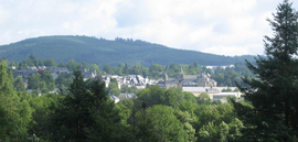 A general view of Meymac | |
 Coat of arms | |
Location of Meymac  | |
 Meymac  Meymac | |
| Coordinates: 45°32′12″N 2°08′52″E / 45.5367°N 2.1478°E | |
| Country | France |
| Region | Nouvelle-Aquitaine |
| Department | Corrèze |
| Arrondissement | Ussel |
| Canton | Plateau de Millevaches |
| Intercommunality | Haute-Corrèze Communauté |
| Government | |
| • Mayor (2020–2026) | Philippe Brugère[1] |
| Area 1 | 87.15 km2 (33.65 sq mi) |
| Population (Jan. 2020)[2] | 2,291 |
| • Density | 26/km2 (68/sq mi) |
| Time zone | UTC+01:00 (CET) |
| • Summer (DST) | UTC+02:00 (CEST) |
| INSEE/Postal code | 19136 /19250 |
| Elevation | 593–973 m (1,946–3,192 ft) |
| 1 French Land Register data, which excludes lakes, ponds, glaciers > 1 km2 (0.386 sq mi or 247 acres) and river estuaries. | |
Meymac (French pronunciation: [memak]; Occitan: Maismac) is a commune in the department of Corrèze, in central France.
YouTube Encyclopedic
-
1/5Views:2 331654838361464
-
Corrèze, Meymac et ses alentours.
-
Meymac
-
meymac sous la neige
-
Meymac Summer Sports Trip
-
COUNTRY OF MEYMAC N°2 copyright 2011 S.2306Punky.
Transcription
History
During the Hundred Years' War it was pillaged by Rodrigo de Villandrando.
Geography
The commune lies just south of the Millevaches Plateau and northwest of the Cantal mountains.
The Luzège has its source in the northern part of the commune; it flows south through the middle of the commune and crosses the town. The Triouzoune forms most of the commune's eastern boundary.
Meymac station has rail connections to Limoges, Brive-la-Gaillarde, Ussel and Bordeaux.
Population
| Year | Pop. | ±% p.a. |
|---|---|---|
| 1968 | 2,410 | — |
| 1975 | 2,434 | +0.14% |
| 1982 | 2,523 | +0.51% |
| 1990 | 2,796 | +1.29% |
| 1999 | 2,627 | −0.69% |
| 2007 | 2,643 | +0.08% |
| 2012 | 2,449 | −1.51% |
| 2017 | 2,366 | −0.69% |
| Source: INSEE[3] | ||

Sights
See also
References
- ^ "Répertoire national des élus: les maires" (in French). data.gouv.fr, Plateforme ouverte des données publiques françaises. 13 September 2022.
- ^ "Populations légales 2020". The National Institute of Statistics and Economic Studies. 29 December 2022.
- ^ Population en historique depuis 1968, INSEE
External links
Wikimedia Commons has media related to Meymac.
- (in French) Meymac and the Mont Bessou, its observation tower, photos of the panorama and the surroundings
| International | |
|---|---|
| National | |
This Corrèze geographical article is a stub. You can help Wikipedia by expanding it. |