
Meghradzor Մեղրաձոր | |
|---|---|
 The village of Meghradzor | |
 Meghradzor Մեղրաձոր | |
| Coordinates: 40°36′53″N 44°38′59″E / 40.61472°N 44.64972°E | |
| Country | Armenia |
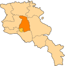
| Province | Kotayk |
| Founded | 1830 |
| Area | |
| • Total | 6.21 km2 (2.40 sq mi) |
| Elevation | 1,820 m (5,970 ft) |
| Population (2009) | |
| • Total | 2,884 |
| • Density | 460/km2 (1,200/sq mi) |
Meghradzor (Armenian: Մեղրաձոր), meaning, valley of honey; formerly known as Taycharukh), is a village in the Kotayk Province of Armenia, 15 kilometres (9 mi) northwest of Hrazdan. The village is located to the south of the Tsaghkunyats mountain range, along the left bank of the Marmarik River. It was founded my immigrants from Aratsap in 1830 and is well known for its famous honey, hence, the name Meghradzor literally translates to valley of honey. The nearby village of Gorgoch is also included in the community of Meghradzor.
The community has a secondary school, kindergarten, first aid station, house of culture, and library. The local economy is heavily dependent on agriculture, based predominantly on beekeeping, cattle-breeding, and farming (potatoes, cabbages, and grains). There is also a disused gold mine north of Meghradzor that has been in use since the 19th century. In the foothills nearby, to the south, is the 12th-century walled Chalcedonian Armenian Tejharuyk Monastery.[1][2]
YouTube Encyclopedic
-
1/3Views:2 4934 9101 421
-
Երկիրը Երկիր է - Կոտայքի մարզ, Մեղրաձոր , մաս 4
-
Երկիրը երկիր է - Նորաշեն, մաս 1
-
Mi lav or Mexradzorum 2012
Transcription
Gallery
-

S. Astvatsatsin Church in the village, 1881
-

Tejharuyk Monastery, 1196–99
See also
References
- ^ "Meghradzor (Kotayk)". CAA: Union of Communities of Armenia. Retrieved May 31, 2015.
- ^ Kiesling, Brady; Kojian, Raffi (2005). Rediscovering Armenia: Guide (2nd ed.). Yerevan: Matit Graphic Design Studio. pp. 96–97. ISBN 99941-0-121-8.
- Meghradzor at GEOnet Names Server
- World Gazeteer: Armenia[dead link] – World-Gazetteer.com
- Report of the results of the 2001 Armenian Census, Statistical Committee of Armenia
External links
This article about a location in Kotayk Province, Armenia is a stub. You can help Wikipedia by expanding it. |