To install click the Add extension button. That's it.
The source code for the WIKI 2 extension is being checked by specialists of the Mozilla Foundation, Google, and Apple. You could also do it yourself at any point in time.
How to transfigure the Wikipedia
Would you like Wikipedia to always look as professional and up-to-date? We have created a browser extension. It will enhance any encyclopedic page you visit with the magic of the WIKI 2 technology.
Try it — you can delete it anytime.
Install in 5 seconds
Yep, but later
4,5
Kelly Slayton
Congratulations on this excellent venture… what a great idea!
Alexander Grigorievskiy
I use WIKI 2 every day and almost forgot how the original Wikipedia looks like.
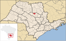
Matão is a municipality in the state of São Paulo in Brazil. As of 2020, the town had an estimated population of 83,626 and a population density of 146.3 persons per km². The total area the city is 524.899 square kilometres (202.665 sq mi). Matão sits at an elevation of 585 metres (1,919 ft). The municipality consists of two districts: Matão and São Lourenço do Turvo.[2]
YouTube Encyclopedic
1/3
Views:
15 753
4 859
1 636
Uma cidade chamada MATÃO
Mulher é espancada no centro de Matão
Drone Matão - SP
Transcription
History
Matão was first populated by coffee growers at the beginning of the 1890s. The settlers constructed a small chapel in 1894, and in 1895 called their settlement Senhor do Bom Jesus das Palmeiras. The settlement was renamed Matão in 1897 and became a district of Araraquara. It became an independent municipality on August 27, 1898. The region attracted more small-scale farmers in the 1890s, and development was furthered by the construction of a railroad line, the Estrada de Ferro Araraquara, which was built to connect Rio Claro, in São Paulo State, to Cuiabá, the capital city of Mato Grosso. The rail line reached Matão by 1899. The municipality comprised three districts, Matão, Dobrada and São Lourenço do Turvo, until 1964 when Dobrada became a separate municipality.[3][2]
Events
Corpus Christi (Solemnity of the Body and Blood of Christ) Feast
Matão is one of the Brazilian cities renowned for its Corpus Christi festivities, which have been celebrated since 1948. On this day streets of the city are decorated with temporary "rugs" made of crushed colored glass, coffee powder, and other materials in preparation for a religious procession. These rugs feature religious and municipal scenes and colorful floral and geometric designs.[4][5]