

Besides being sovereign over the principality of Orange ![]() , this is a partial listing of larger estates and titles that William the Silent and his heirs possessed, most enfeoffed to some other sovereign, either the King of France, the Habsburgs, or the States of the provinces of the Netherlands[1]
, this is a partial listing of larger estates and titles that William the Silent and his heirs possessed, most enfeoffed to some other sovereign, either the King of France, the Habsburgs, or the States of the provinces of the Netherlands[1]
- Marquis of Veere and Vlissingen


Dietz ![]() ,
Vianden
,
Vianden ![]() ,
Buren
,
Buren ![]() ,
Moers
,
Moers ![]() ,
Leerdam
,
Leerdam ![]() , and
Culemborg (1748)
, and
Culemborg (1748) ![]()
Cranendonck ![]() ,
Lands of Cuijk
,
Lands of Cuijk ![]() ,
Eindhoven
,
Eindhoven ![]() ,
City of Grave
,
City of Grave ![]() ,
Lek
,
Lek ![]() ,
IJsselstein
,
IJsselstein ![]() ,
Acquoy
,
Acquoy ![]() ,
Diest
,
Diest ![]() ,
Grimbergen
,
Grimbergen ![]() /
/![]() ,
Herstal
,
Herstal ![]() ,
Warneton (Waasten (nl))
,
Warneton (Waasten (nl)) ![]() ,
Beilstein
,
Beilstein ![]() ,
Bentheim-Lingen
,
Bentheim-Lingen ![]() ,
Arlay
,
Arlay ![]()
![]() ,
Nozeroy
,
Nozeroy ![]() , and
Orpierre
, and
Orpierre ![]() ;
;
Bredevoort ![]() ,
Dasburg
,
Dasburg ![]() ,
Geertruidenberg
,
Geertruidenberg![]() ,
Hooge en Lage Zwaluwe
,
Hooge en Lage Zwaluwe ![]() ,
Klundert
,
Klundert![]() ,
't Loo
,
't Loo ![]() ,
Montfort,
,
Montfort, ![]() Naaldwijk
Naaldwijk ![]() ,
Niervaart,
Polanen/lands of Polanen
,
Niervaart,
Polanen/lands of Polanen ![]() ,
Steenbergen
,
Steenbergen ![]() ,
Sint-Maartensdijk
,
Sint-Maartensdijk ![]() ,
Turnhout
,
Turnhout ![]() & Zevenbergen
& Zevenbergen ![]() ,
Willemstad
,
Willemstad ![]() ,
Bütgenbach
,
Bütgenbach![]() ,
Sankt Vith
,
Sankt Vith ![]() , and
Besançon
, and
Besançon![]()
Maps of Lands
Soveriegn Titles
King of the Netherlands
| Name | Timespan | Map | Coat of Arms | Historic Map |
|---|---|---|---|---|
| King of the Netherlands Koning der Nederlanden |
1815–present -The monarch of the Netherlands is constitutionally always considered "king" to ensure the powers are continuous. |
 Amsterdam (Capital & largest city) Amsterdam (Capital & largest city) (Netherlands) |
 Royal Arms since 1907 |
|
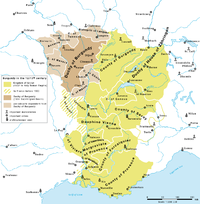
Principality of Orange
The original main title was taken from the Principality of Orange on the Rhone River outside Avignon and the papal lands of the Comtat Venaissin. The principality was 108 sq mi (280 km2). However, the prince was a sovereign monarch, which put him on the same plane as the kings and monarchs of Europe and the world. This is much the same situation as Monaco today.
| Name | Timespan | Map | Coat of Arms | Historic Map |
|---|---|---|---|---|
| Prince of Orange Prince d'Orange |
793?/885 - 1713 titular 1713-present - Founded by First House of Orange- 885 |
 Orange Orange (France) |
  Principality of Orange |

|
| Lord of Aumelas Seigneur de Aumelas |
- 1544 - 1795
-The Lordship of Aumelas was part of the titles of the first Counts of Orange, but not part of the sovereign principality. |
 Aumelas Aumelas (Occitanie) |
 
|
 Map of Aumelas |
Grand Duke of Luxembourg (1815-1890)
| Name | Timespan | Map | Coat of Arms | Historic Map |
|---|---|---|---|---|
| Grand Duke of Luxembourg Groussherzog vu Lëtzebuerg Grand-duc de Luxembourg |
1815 - 1890 -The Grand Duchy was setup as an associated part of the German Confederation in 1815, but ruled by the King of the Netherlands. |
 Luxembourg City (Capital & largest city) Luxembourg City (Capital & largest city) (Luxembourg) |
 Grand Ducal Arms |
 Partitions of Luxembourg |
| Duke of Limburg Hertog van Limburg |
1839 - 1867 -The Duchy was setup as originally as provinces of the United Kingdom of the Netherlands (1815-1830) and an associated part of the German Confederation in 1815, but ruled by the King of the Netherlands and consolidating several older states, including the Duchy of Limburg/Hertogdom Limburg.
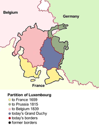
-In the founding of the Belgian state in 1830-1831 the status of Luxembourg and Limburg was at issue. Along with Luxembourg being partitioned, the Dutch thus created the Duchy of Limburg (consisting of the Province of Limburg minus its two major cities, Maastricht and Venlo). |
Roermond Roermond (Netherlands) |
  Ducal Arms |
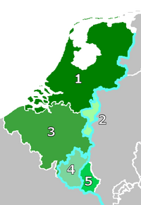 The Exchange of 1839. The removal of Western Luxembourg (4) from the German customs union by Belgium (3) resulted in compensation by the Netherlands (1) by the creation of the Duchy of Limburg (2) (this territory was controlled by Belgium until 1839). |
Germany
Ancestral Lands
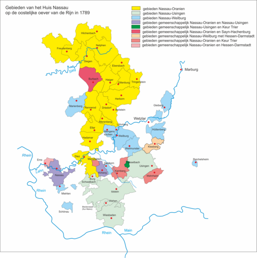
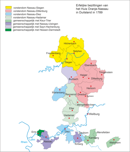
Initially, the family was known as “of Nassau” after their oldest possession the County of Nassau and their part of the subdivision of the lands, the Countship of Nassau-Dillenburg. This was divided and subdivided amongst the descendants of John the Elder. It generally comprised the northern part of the entire county of Nassau, north of the Lahn River. It was reunited in the 18th century under the line of Nassau-Dietz.
| Name | Timespan | Map | Coat of Arms | Historic Map |
|---|---|---|---|---|
| Princely County of Nassau (Ancestral Estate of the House of Nassau, Imperial Immediate Estate) Gefürstete Grafschaft Nassau specifically Count of Nassau in Dillenburg, Siegen, Dietz, Hadamar, Beilstein, which were all subdivisions of Nassau. |
915 - 1866 - Founded and Acquired by the Lords of Laurenburg 915 – 1125 |
 Nassau Nassau (Germany) |
  Count of Nassau |

Subdivisions of Nassau
These subdivisions (baronies and lordships) of Nassau were split into semi-autonomous countships and pricipalities for the younger members of the House of Nassau. The title for these was Count of Nassau in xyz.
| Name | Timespan | Map | Coat of Arms | Historic Map |
|---|---|---|---|---|
| Count of Nassau in Dillenburg Barony of Dillenburg |
1254-1805
-Ancestral seat of the Royal House of the Netherlands. |
Dillenburg Dillenburg (Germany) |
  The Counts of Nassau in Dillenburg to 1739  Civic Arms |
 Dillenburg in Nassau 1547 |
| County of Diez or Dietz Grafschaft Diez or Dietz |
-Probably created as a successor to the original county of the Conradines in Niederlahngau.
-In 1388 part passed via his daughter Jutta to his son-in-law, Adolf I, Count of Nassau-Siegen. |
Diez Diez (Germany) |
 Count of Diez |
|
| Count of Nassau in Siegen Barony of Siegen |
1303-1328/1606-1743
-After John VII died in 1628, the country was divided: his eldest son, John VIII, who had converted to Catholicism, received the part of the county south of the river Sieg. John Maurice, who remained Protestant, received the part of the county north of the Sieg. |
Siegen Siegen (Germany) |
The Counts of Nassau in Siegen to 1679  Counts of Nassau in Siegen to 1743  Civic Arms |
 The baronies and lordships of Nassau by Blaeu in 1645 |
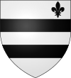
| Count of Nassau in Beilstein Barony of Beilstein |
- Founded 1129
-Acquired by Otto I around 1287 |
Nassau-Beilstein Nassau-Beilstein (Germany) |
 Lord and Baron of Beilstein |
The baronies and lordships of Nassau by Blaeu in 1645 |
| Count of Nassau in Hadamar |
1620-1743
-Seat of a younger line of the Ottonian Nassaus, starting with John Louis |
Nassau-Hadamar Nassau-Hadamar (Germany) |
Lord and Baron of Hadamar |
The baronies and lordships of Nassau by Blaeu in 1645 |
| Count of Nassau in Schaumburg County of Holzappel, Lordship of Schaumburg |
1643–1692
-In 1643, the Lordship of Esterau along with the bailiwick of Isselbach was purchased by Imperial Field Marshal Peter Melander, Count of Holzappel (1641), from John Louis of Nassau-Hadamar, who was in considerable financial difficulty. Emperor Ferdinand III raised the Lordship to the Imperial County of Holzappel.[2] |
Schaumburg Schaumburg (Germany) |
 Lord and Baron of Schaumburg |
Other German Lands
Additionally, the House of Nassau acquired other lands in and around their ancestral estates:
| Name | Timespan | Map | Coat of Arms | Historic Map |
|---|---|---|---|---|
| County of Katzenelnbogen (claimed) Grafschaft Katzenelnbogen |
- Founded and Acquired by Diether I as Vogt of Abby of Prüm Abbey -In 1479, the male line of the Katzenelnbogens became extinct. The Obergrafschaft was passed to the Landgraves of Hesse by virtue of the 1458 marriage of Henry III of Upper Hesse to Count Philipp's daughter Anna of Katzenelnbogen -The counts of Nassau also claimed Katzenellenbogen, and the Monarchs of the Netherlands still claim this as part of their title |
Katzenelnbogen Katzenelnbogen (Germany) |
 Count of Katzenellenbogen |

|
| County of Lingen Grafschaft Lingen |
- Founded 1180 under Henry the Lion and Frederick Barbarossa.
-Acquired by House of Tecklenburg-Schwerin, 1388 |
Lingen Lingen (Germany) |
 Count of Lingen |

|
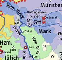
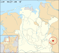
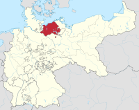
| County of Moers Graafschap Meurs |
- -1186, independent principality
-During the Eighty Years' War it was alternately captured by Spanish and Dutch troops, |
Moers Moers (Germany) |
 Count of Meurs |
|
| County of Spiegelberg Grafschap van Spiegelberg |
-1631 - 1819
-abt 1200, for Counts of Poppenburg -Sold to King of Hannover in 1819. |
Spiegelberg Spiegelberg (Germany) |
 Count of Spiegelberg |
|
Other Paternal Estates of the Royal House
Once the House of Nassau acceded to the royal throne, the Queens married with these representatives of other royal houses:
| Name | Married | Map | Coat of Arms | Historic Map |
|---|---|---|---|---|
| Grand Duchy of Mecklenburg-Schwerin | Queen Wilhelmina m. Duke Henry of Mecklenburg-Schwerin  |
Schwerin Schwerin (Germany) |
  |
 Grand Duchy of Mecklenburg-Schwerin within the German Empire |
| Principality of Lippe-Beisterfeld | Queen Juliana m. Prince Bernhard of Lippe-Biesterfeld  |
Detmold, Lippe Detmold, Lippe (Germany) |
 |
 Principality of Lippe within the German Empire
|
| Amsberg | Queen Beatrix m. Claus von Amsberg  |
N/A |  |
N/A |

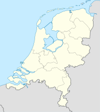
The Netherlands
Most of the estates of the family were in the Netherlands in the more populous provinces of northern Brabant, southern Holland, and Zealand, around the delta of the Rhine/Scheldt/Maas rivers, the trading center made by them, and its entrance to the sea. The land itself was secondary to the profit on the commerce that flowed through it and the political influence that accrued with them (see Western Netherlands Commercial Center which developed into Amsterdam Trading Center, which later developed into the Dutch Randstad.).
The family properties in the Netherlands centered around the Barony of Breda. The barony sat on the delta of the Rhine in northwestern Brabant. Before the revolt the main residence of the family outside the Nassau Palace in Brussels was the castle and fortress of Breda. It was as also relatively close to their important function of Viscount of Antwerp. This fortress withstood several sieges during the 80 years war if the Dutch Revolt, but is most famous for being captured in 1624 by the Spanish as immortalized by Velazquez.
The county of Vianden sat high above a tributary of the Moselle that flowed into the trade routes of the Rhine into western Germany and the Netherlands. In the 12th to 15th centuries the counts of Vianden were the mightiest lords of the area between the rivers Rhine, Mosel and Maas. Their territory was in modern Vianden canton, Luxemburg and Bitburg-Prüm, Germany.
William the Silent married as his first wife Anna van Egmont heiress of Maximiliaan van Egmond, Count of Buren. This also included the counties of Leerdam and Lingen. While these lands devolved to Anna's son Philip William, as he died without heirs, they devolved to the prince of Orange. The hier/eldest son of the prince of Orange was titled “Count of Buren”. It remains one of the subsidiary titles of the Dutch Monarch.
Northern Netherlands/later the Dutch Republic & the Kingdom of the Netherlands
These counties, baronies and lordships are in the official titulature of the monarch of the Netherlands:
| Name | From | Timespan | Map | Coat of Arms | Historic Map |
|---|---|---|---|---|---|
| Barony of Breda Baronie van Breda in Brabant/Staats-Brabant |
Van Polanen family | 1403 – now - The center of all the Orange-Nassau lands in the Netherlands - 1350 sold by Duke of Brabant to John I, Lord of Polanen, the van Polanens were a cadet of the van Wassenaers - Engelbert I of Nassau married Johanna van Polanen in 1403, making the House of Nassau a large landowner in the Netherlands for the first time. - one of the titles of the Monarch of the Netherlands is still "Baron of Breda", 
|
 Breda Breda (Benelux) |
|
|
| Lord of Polanen | Van Polanen family | 1403 – now -van Polanen en Polanen Castle (near Monster) & Duivenvoorde Castle
-2x Baron: van Breda (see above) and van Herstal |
Polanen Duivenvoorde de Lek barony of Herstal Geertruidenberg Niervaart/Klundert Montfoort Naaldwijk Steenbergen Maps of the Lands of the House of Orange (Benelux) |

|

Map of the heerlijkheid van de Lek from van Blaeu 1645.
|
| County of Buren Graafschap Buren in Gelderland |
Egmond-Buren | 1395 - now - Inherited by the Egmonds. - 1498 made a county. - Inherited by Nassau Family when William the Silent married Anna van Egmont in 1551 |
Buren Buren (Benelux) |

|
 The county of Buren in 1665 south of the Lek branch of the Rhine. |
| The County of Leerdam Graafschap van Leerdamin Utrecht |
Egmond-Buren | c.1279 - now - formed a part of the Vijfheerenlanden domain, -raised County in 1498. - in 1551, inherited by Nassau Family with Acquoy when William the Silent married Anna van Egmont in 1551. |
Leerdam Leerdam (Benelux) |
 Arms of Leerdam with the arms of the Count of Leerdam on the lefthand lion. |
 Leerdam in the 16th century |
| The County of Culemborg Graafschap van Culemborgin Gelderland |
awarded by States of Gelderland | 1748 - 1795 - Given to William IV by the States of Gelderland |
Culemborg Culemborg (Benelux) |
 Arms of Counts of Culemborg |
 County of Culemborg in the 17th century
|
| Barony and city of IJsselstein Baronie IJsselstein in Utrecht |
Egmond-Buren | c.1279 - now - created for the Van Amstel family. - in 1363 inherited by the Inherited by Egmonds. - Inherited by Nassau Family when William the Silent married Anna van Egmont in 1551. |
IJsselstein IJsselstein (Benelux) |

|
 1649 map of IJsselstein in Willem and Joan Blaeu's "Toonneel der Steden" |
| Lordship and barony of Cranendonck Heerschap en baronie van Cranendonck in Brabant/Staats-Brabant |
Egmond-Buren | 1072 - 1795
- First mentioned 1223, as Castle Cranendonck, inherited by William van Cranendonck. |
Cranendonk Cranendonk (Benelux) |

|
|
| Lordship and barony of Einhoven Heerschap en baronie van Eindhoven in Brabant/Staats-Brabant |
Egmond-Buren | 1100 - 1795
- Motte and Bailey castle in 1100. In 1232, Eindhoven was still in the possession of Duke Henry II of Brabant, but the manor of Eindhoven was probably given to Willem, lord of Cranendonck, in 1282. |
Eindhoven Eindhoven (Benelux) |

|
|
| Lordship and barony of Acquoy Heerschap en baronie van Acquoy in Gelderland |
Egmond-Buren | 1551 - present
- In 1305 Acquoy is mentioned as part of the property of the lords of Voorne. Bought by Otto van Arkel and added to the Lordship of Arkel. After Acquoy changed hands several times, it was bought by Floris van Egmond, Count of Buren, in 1513. |
Acquoy Acquoy (Benelux) |

|
  Acquoy within West Betuwe |
| Lordship and barony of Liesveld Heerschap en baronie van Baronie Liesveld in Holland |
Bought | 1072 - 1795
- created as a lordship 1072. |
Liesveld Liesveld (Benelux) |

|

|
| Lordship and city of St Martinsdijk Heerschap van Sint Maartinsdijk in Zeeland |
Egmond-Buren | c.1xxx - now - created for the . - Inherited by Philip William from the Egmonds s part of the county of Buren and willed to his brothers. As the only noble left in Zealand, it gave him the position of First Noble in the Zeeland Estates (nl) and the vote for the nobility in the Estates of Zealand (Zealand gov't). in Zeeland |
St. Martinsdijk St. Martinsdijk (Benelux) |

|
 Map of St. Maartensdijk |
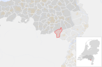
| Marquisate of Veere and Vlissingen markiezaat van Vlissingen en Kampenveere in Zeeland |
Bought | 1582 - present
-Purchased in 1582 by William the Silent. |
Flushing Veere Maps of the Lands of the House of Orange (Benelux) |
  Marquis of Veere and Flushing   Veere & Flushing |
 1649 map of Flushing  1681 map of Walcheren |
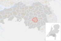
| Barony of Cuijk Heerschap en baronie van de stad Grave en het Land van Cuijk. in Brabant/Staats-Brabant |
Granted | 11th Century - 1795
- 1559 granted to William the Silent -reconquered in 1602 by Maurice of Nassau. |
Cuijk Grave Maps of the Lands of the House of Orange (Benelux) |
 Lord of Cuijk  Lord of Grave |

|


| Name | From | Timespan | Map | Coat of Arms | Historic Map |
|---|---|---|---|---|---|
| Lordship of Baarn, Soest en Ter Eem Hoge Heerschap van Baarn, Soest en Ter Eem in Utrecht |
Bought | 1674 - present
-The "lordship of the Zoestdijck" was purchased in 1674 by Stadtholder Willem III from the Amsterdam regent family De Graeff. |
Baarn Soest Ter Eem Maps of the Lands of the House of Orange (Benelux) |
 Baarn |
 Baarn
|
| Lordship of Bredevoort Heerschap van Bredevoort in Gelderland |
Conquered | 1697 - present
- Maurice of Nassau, Prince of Orange conquered Bredevoort in the year 1597 on the Spanish occupation. |
Bredevoort Bredevoort (Benelux) |

|
  Bredevoort |
| Lordship of Hooge en Lage Zwaluwe Heerschap van Hooge en Lage Zwaluwe in Brabant/Staats-Brabant |
Granted by Charles V | 1518 - present
- Awarded to Henry III of Nassau-Breda by Emperor Charles V in 1518. |
Zwaluwe Zwaluwe (Benelux) |

|
 Hooge en Lage Zwaluwe |
| Lordship of Het Loo (meaning "The Lea: field, clearing, meadow") Heerschap van Het Loo in Gelderland |
Bought | 1684 - present
-Bought in 1684 by William III, it was owned before that by the Bentinck family. It came with the lordships of Apeldoorn, Beekbergen en Loenen. William was primarily interested in the hunting in the area. The palace he built primarily functioned for him as a hunting lodge. |
Het Loo Het Loo (Benelux) |

|
 Hooge en Lage Het Loo with Het Loo Palace |
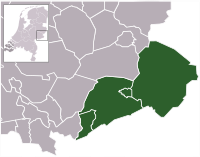
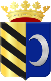
| Lordship of Zevenbergen and Turnhout Heer van Zevenbergen en Turnhout in Brabant/Staats-Brabant |
Granted by Philip IV | 1647 - present
-Given by King Philip IV of Spain to Amalia van Solms-Braunfels, wife of Prince Frederick Henry, and then to William III. |
Zevenbergen Turnhout Maps of the Lands of the House of Orange (Benelux) |
  Turnhout  Zevenbergen |
 Turnhout  Zevenbergen |
| Lordship of Willemstad Heer van Willemstad in Brabant/Staats-Brabant |
Granted by the States | 1583 - present
-The current name was first used in 1639 as Willemstat, and refers to William the Silent who fortified the settlement in 1583. |
Willemstad Willemstad (Benelux) |

|
 Willemstad by Blaeu  Willemstad |
| Free Lordship of Ameland Erf- en vrijheer van Ameland in Friesland |
Bought | 1708 - present
- Ameland is one of the Frisian islands. It remained a free lordship until the ruling family, Cammingha, died out in 1708. |
Ameland Ameland (Benelux) |
|
 Ameland |
| Lordship of Borculo & Lichtenvoorde Heer van Borculo en Lichtenvoorde in Friesland. |
Bought | 1776 - present
-The lordship of Borculo & Lichtenvoorde was bought in 1776 by William V from the Polish Prince Adam Kazimierz Czartoryski.  Family of Borculo |
Borculo Lichtenvoorde Maps of the Lands of the House of Orange (Benelux) |
 Van Bronkhorst  Lordship of Borculo  Lordship of Lichtenvoorde |
 Lordship of Borculo in 1741
|
| Lordship of Montfort Heer van Montfort in Generality Lands - Upper Guelders of the States (Staats-Opper-Gelre |
Awarded | 1647 - present
-The manor of Montfort was founded by Hendrik III of Guelders.
-It was given by Philip IV of Spain to Stadtholder William II in 1647. After his death, Montfort came to William III. |
Montfort Montfort (Benelux) |
 Lordship of Montfort |
 Lordship of Montfort
|


These lordships are not in the official titulature of the monarch of the Netherlands, but are cited on the board in the picture.
| Name | From | Timespan | Map | Coat of Arms | Historic Map |
|---|---|---|---|---|---|
| Lordship & Bannership of Wisch Heerlijkheid & Bannerij van Wisch in Gelderland |
lords of Wisch via House of Limburg-Stirum through House of Nassau-Siegen (1646) | House of Limburg-Stirum
1646 – now
- The Wisch family were Ministerialis. They were rewarded with the lordship by the Bishop of Munster. |
Wisch Wisch (Benelux) |
 Lordship of Wisch Nassau-Siegen showing Wisch |
 The lordship of Wisch in 1741 
|
| Lordship of :Dinteloord & Prinsenland Heerlijkheid van Dinteloord en Prinsenland in Brabant/Staats-Brabant |
1605-present
- Before the dyking and draining of the polder the area was called Dinteloord and was part of the lordship of Steenbergen. |
Prinsenland Prinsenland (Benelux) |
  Lordship of Prinsenland 2 versions of the arms |
 The lordship of Prinsenland in the upper Left | |
| Lordship of Colijnsplaat Heerlijkheid van Colijnsplaat in Zeeland |
Colijnsplaat Colijnsplaat (Benelux) |

|
 The lordship of Colijnsplaat 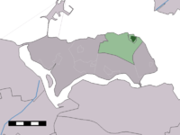 Colijnsplaat in the town of Noord-Beveland | ||
| Lordship of Scherpenisse Heerlijkheid van Scherpenisse in Zeeland |
Egmond-Buren | 1551-present
- The name Scherpenisse is first mentioned in 1203 as Scarpenesse. -Scherpenisse was one of the five islands that would together form the island of Tholen. The village arose near a dammed side channel of the Oosterschelde. |
Scherpenisse Scherpenisse (Benelux) |
 Lordship of Scherpenisse  Town of Scherpenisse |
 Scherpenisse in the municipality of Tholen |
The Southern Netherlands/later the Spanish & Austrian Netherlands, and the Kingdom of Belgium
While not as substantial as their interests in the northern Netherlands, the estates in the southern Netherlands were in the more populous provinces, in this case Brabant (most importantly Antwerp) around the river systems that ultimately flowed to the sea through the commercial entrepot of Antwerp. Again, the land itself was secondary to the profit on the commerce that flowed through it and the political influence that accrued with them (see Southern Netherlands Commercial Center which developed into Antwerp Trading Center, which later developed into the Belgian Flemish Diamond.).
| Name | From | Timespan | Map | Coat of Arms | Historic Map |
|---|---|---|---|---|---|
| Burgrave (Viscount) of Antwerp Burgraaf van Antwerpen in Brabant |
lords of Heinsberg | - title from the Margraviate of Antwerp(nl) as an inheritable office by the lords of Heinsberg.
-It passed down through several families until finally inherited and traded for by Engelbrecht II of Nassau-Breda in 1499. -The most famous holder was William the Silent. -It was a center for the Dutch Revolt before its recapture by the Spanish and confiscation of the position by Philip II in 1567. -Subsequently in the Low countries, the rank of burggraaf evolved into the nobility synonymous with viscount.[9][10][11][12][13] The title "Viscount of Antwerp" is still claimed by the reigning monarch of the Netherlands as one of its subsidiary titles.[14] |
Antwerp Antwerp (Benelux) |
 
|
 City of Antwerp in 1572 looking up the Scheldt at its height as the entrepôt of Western Capitalism 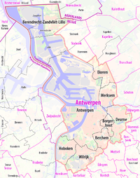
|
| Lordship and barony of Diest Heerschap en baronie van Diest in Brabant |
lords of Heinsberg | 1499 - 1795
-Engelbrecht II of Nassau-Breda became baron in 1499, through an exchange of territories with Duke William IV of Gulik (see Antwerp below). |
Diest Diest (Benelux) |

|
|
| Lordship and of Zichem Heerschap van nl:Titels van de Nederlandse koninklijke familie#Burggraaf van Antwerpen Zichem in Brabant |
lords of Heinsberg | 1499 - 1795
-Part of inheritance that brought the Burgraviate of Antwerp (see above) |
Zichem Zichem (Benelux) |

|
 Zichem in Flemish Brabant |
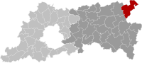
| Lordship and barony of Warneton Heerschap en baronie van Waasten in County of Hainaut (now Hainaut Province) |
House of Luxembourg | 1511 - 1795
-The barony of Warneton (called Waasten in Dutch) was mentioned as a seigneury as early as the 13th century. |
Warneton Warneton (Benelux) |

|

|
These lordships are not mentioned in the titulature, but are shown on the board of Lordships:
| Name | From | Timespan | Map | Coat of Arms | Historic Map |
|---|---|---|---|---|---|
| Lordship and barony of Meerhout Heerschap en baronie van Meerhout in Brabant |
Meerhout Meerhout (Benelux) |
|

| ||
| Lordship and barony of Vorst Heerschap en baronie van Vorst in Brabant |
? ? (Benelux) |
 which are the arms of the Lords of Diest above |
the Duchy of Luxembourg/later the Grand Duchy of Luxembourg
| Name | From | Timespan | Map | Coat of Arms | Historic Map |
|---|---|---|---|---|---|
| County of Vianden Graafschap Vianden in Luxembourg |
Lords of Sponheim | approx. 1100 - approx 1566
- Founded and Acquired by the Lords of Sponheim 915 – 1125 - Inherited by Nassau Family 1417 from Elisabeth van Sponheim-Kreuznach. -Subsidiary lordships: St. Vith(nl) -Confiscated by the French in 1786. |
Vianden St. Vith Bütgenbach Dasburg Grimbergen Maps of the Lands of the House of Orange (Benelux) |

|
 The region around Vianden in 1400. Vianden is in light green surrounded by the duchy of Luxembourg in light brown. In the 12th to 15th centuries the counts of Vianden were the mightiest lords of the area between the rivers Rhine, Mosel and Maas. |
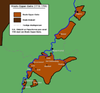
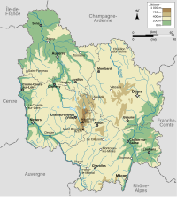
Franche-Comté (Free County of Burgundy)
Franche-Comté was controlled by the King of Spain, so the princes of Orange lost control of the lands that they had inherited from the previous princes of Orange, the House of Chalon-Arlay, the Viscountship of Besançon and lordships of Chalons itself, Arlay, Nozeroy. By the time the King of France had conquered the county of Burgundy, the prince of Orange (William III) was at odds with the King, Louis XIV.
| Name | From | Timespan | Map | Coat of Arms | Historic Map |
|---|---|---|---|---|---|
| Baron of Arlay Baron de Arlay |
House of Chalon-Arlay | - 1544 - 1795
-In the thirteenth century the barony of Arlay, on the borders with the Bresse region, passed into the dynasty of the counts of Châlons, the preeminent noblemen in the south of the Franche-Comté. They controlled the exploitation of salt mined at Salins. |
 Arlay Arlay (Bourgogne-Franche-Comté) |
  Barons of Arlay & Barons of Chalons-Arlay (after 1256) |
 Map of County of Burgundy showing Arlay, 1716 |
| Baron of Nozeroy Baron de Nozeroy |
House of Chalon-Arlay | - 1544 - 1795
-In the thirteenth century the barony of Arlay, on the borders with the Bresse region, passed into the dynasty of the counts of Châlons, the preeminent noblemen in the south of the Franche-Comté. They controlled the exploitation of salt mined at Salins. |
Nozeroy Nozeroy (Bourgogne-Franche-Comté) |
 Barons of Nozeroy |
 County of Burgundy at the end of the XVth Century showing Nozeroy |
| Baron of Orpierre Baron de Orpierre |
House of Chalon-Arlay | - 1544 - 1702
- 1349 left to Jean II de Chalon-Arlay, prince of Orange by his cousin. |
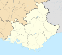 Orpierre Orpierre (Provence-Alpes-Côte d'Azur) |
 Barons of Orpierre |
 Location of Orpierre |
| Viscount of Besançon Vicomté de Besançon |
House of Chalon-Arlay | - 1184 - 1795
-Imperial Free City 1184, independent Imp Free City 1290 -The office of viscount was the same as the rank of burgrave in the Holy Roman Empire, of which the County of Burgundy as part of . |
Besançon Besançon (Bourgogne-Franche-Comté) |
 Viscounts of Besançon |
County of Burgundy at the end of the XVth Century showing Nozeroy |
| Name | From | Timespan | Map | Coat of Arms | Historic Map |
|---|---|---|---|---|---|
| Chalon Comte de Chalon Did these go to the Nassaus? |
10th century–1401 - 1401, the last count died -his heir Odo of Thoire-Geneva sold the comté to Count Amadeus VIII of Savoy. -members of the Genevan House protested, and the House of Chalons (and, after its extinction, the House of Orange-Nassau) remained the strongest claimant. |
Geneva Geneva (France) |
Counts of Chalons |
|
Switzerland
| Name | Timespan | Map | Coat of Arms | Historic Map |
|---|---|---|---|---|
| Count of Geneva (titular) Comté de Genève |
10th century–1401 - 1401, the last count died -his heir Odo of Thoire-Geneva sold the comté to Count Amadeus VIII of Savoy. -members of the Genevan House protested, and the House of Chalons (and, after its extinction, the House of Orange-Nassau) remained the strongest claimant. |
Geneva Geneva (France) |
 County of Geneva |
|
References
- ^ a b c (in Dutch) Pennings, J.C.M. & Schreuder, E.A.T.M., ‘Heer en meester van Ameland tot Zwaluwe. Het beheer en bestuur van de heerlijkheden van het Huis Oranje-Nassau door de Nassause Domeinraad (14de eeuw–1811)’ in: Klooster, L.J. van der e.a. (red.), Jaarboek Oranje-Nassau Museum 1994, Barjesteh, Meeuwes & Co Historische Uitgeverij, Rotterdam (1995), p. 45-75, ISBN 90-73714-18-4. Cite error: The named reference "pennings" was defined multiple times with different content (see the help page).
- ^ Leopold von Eltester (1881), "Holzappel, Peter Graf zu", Allgemeine Deutsche Biographie (in German), vol. 13, Leipzig: Duncker & Humblot, pp. 21–25
- ^ Wilhelm von der Nahmer: Handbuch des Rheinischen Particular-Rechts, Sauerländer, 1832, S. 577 (Google Books)
- ^ The Central Limburg Montfort (Montfort, see below) is often confused with Montfoort bij Heeswijk in connection with the king's titles, see [http ://www.kasteelmontfort.eu/index.php?mact=News,cntnt01,detail,0&cntnt01articleid=21&cntnt01returnid=68]. The Limburg Montfort was first given (see below) from Philip IV to William II. Frederick the Great, king of Prussia inherited it, but sold the Limburg Montfort castle in 1769 and the manor of Montfort to the House of Orange, who have since used the title Lord (or Lady) of Montfort. This probably means that the Utrecht Montfort near Heeswijk was never a possession of the Polanens.
- ^ Rowen, Herbert H. (1988). The princes of Orange: the stadholders in the Dutch Republic (2 ed.). Baltimore: Cambridge University Press. p. 29. ISBN 978-0-8063-4811-7. LCCN 65021472. :
- ^ Noord-Brabant tijdens de Republiek der Verenigde Nederlanden, Willem A. van Ham, blz.31
- ^ "Colijnsplaat - (geografische naam)". Etymologiebank (in Dutch). Retrieved 20 April 2022.
- ^ Piet van Cruyningen & Ronald Stenvert (2003). Colijnsplaat (in Dutch). Zwolle: Waanders. ISBN 90 400 8830 6. Retrieved 20 April 2022.
- ^ Motley, John Lothrop (1855). The Rise of the Dutch Republic, vol. 2. Harper & Brothers. p. 37.
- ^ Young, Andrew (1886). A Short History of the Netherlands (Holland and Belgium). Netherlands: T. F. Unwin. p. 315.
- ^ Putnam, Ruth (1895). William the Silent, Prince of Orange: the moderate man of the sixteenth century : the story of his life as told from his own letters, from those of his friends and enemies and from official documents, Volume 1. Putnam. p. 211.
viscount of antwerp.
- ^ Parker, Geoffrey (2002). The Dutch Revolt. Penguin.
- ^ Rowen, Herbert H. (1990). The Princes of Orange: The Stadholders in the Dutch Republic. Cambridge Univ. Press.
- ^ Koninklijkhuis (2013). "Frequently asked questions re King William-Alexander". Rijksvoorlichtingsdienst (RVD). Archived from the original (web) on 2013-06-21. Retrieved 2013-05-30.
The King's full official titles are King of the Netherlands, Prince of Orange-Nassau, Jonkheer van Amsberg, Count of Katzenelnbogen, Vianden, Diez, Spiegelberg, Buren, Leerdam and Culemborg, Marquis of Veere and Vlissingen, Baron of Breda, Diest, Beilstein, the town of Grave and the lands of Cuyk, IJsselstein, Cranendonk, Eindhoven and Liesveld, Hereditary Lord and Seigneur of Ameland, Lord of Borculo, Bredevoort, Lichtenvoorde, 't Loo, Geertruidenberg, Klundert, Zevenbergen, Hoge and Lage Zwaluwe, Naaldwijk, Polanen, St Maartensdijk, Soest, Baarn and Ter Eem, Willemstad, Steenbergen, Montfort, St Vith, Bütgenbach and Dasburg, Viscount of Antwerp.