
Mahoning Township, Mountour County, Pennsylvania | |
|---|---|
Township | |
 Schoolhouse Road and summer scenery in Mahoning Township | |
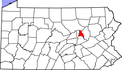
 Map of Montour County, Pennsylvania Highlighting Mahoning Township | |
 Map of Montour County, Pennsylvania | |
| Country | United States |
| State | Pennsylvania |
| County | Montour |
| Settled | 1775 |
| Incorporated | 1786 |
| Area | |
| • Total | 8.87 sq mi (22.99 km2) |
| • Land | 8.20 sq mi (21.24 km2) |
| • Water | 0.67 sq mi (1.74 km2) |
| Population | |
| • Total | 4,628 |
| • Estimate (2021)[2] | 4,604 |
| • Density | 512.56/sq mi (197.89/km2) |
| FIPS code | 42-093-46656 |
Mahoning Township is a township in Montour County, Pennsylvania, United States.
Geography

According to the United States Census Bureau, the township has a total area of 8.9 square miles (22.9 km2), of which 8.2 square miles (21.3 km2) is land and 0.6 square miles (1.6 km2) (7.00%) is water.
Demographics
| Census | Pop. | Note | %± |
|---|---|---|---|
| 2000 | 4,263 | — | |
| 2010 | 4,171 | −2.2% | |
| 2020 | 4,628 | 11.0% | |
| 2021 (est.) | 4,604 | [2] | −0.5% |
| U.S. Decennial Census[3] | |||
As of the census[4] of 2000, there were 4,263 people, 1,466 households, and 963 families residing in the township.
The population density was 517.3 inhabitants per square mile (199.7/km2). There were 1,542 housing units at an average density of 187.1 per square mile (72.2/km2).
The racial makeup of the township was 93.97% White, 1.92% African American, 0.02% Native American, 2.72% Asian, 0.61% from other races, and 0.75% from two or more races. Hispanic or Latino of any race were 1.71% of the population.
There were 1,466 households, out of which 29.4% had children under the age of eighteen living with them; 54.6% were married couples living together, 8.6% had a female householder with no husband present, and 34.3% were non-families. 32.1% of all households were made up of individuals, and 15.8% had someone living alone who was sixty-five years of age or older.
The average household size was 2.32 and the average family size was 2.92.
In the township the population was spread out, with 22.3% under the age of eighteen, 5.2% from eighteen to twenty-four, 22.3% from twenty-five to forty-four, 24.1% from forty-five to sixty-four, and 26.0% who were sixty-five years of age or older. The median age was forty-five years.
For every one hundred females, there were 78.2 males. For every one hundred females aged eighteen and over, there were 72.0 males.
The median income for a household in the township was $43,995, and the median income for a family was $55,536. Males had a median income of $46,016 compared with that of $31,078 for females.
The per capita income for the township was $24,099.
Roughly 2.4% of families and 8.3% of the population were living below the poverty line, including 5.7% of those under the age of eighteen and 18.5% of those who were aged sixty-five or over.
References
- ^ "2016 U.S. Gazetteer Files". United States Census Bureau. Retrieved August 14, 2017.
- ^ a b c Bureau, US Census. "City and Town Population Totals: 2020—2021". Census.gov. US Census Bureau. Retrieved July 27, 2022.
- ^ "Census of Population and Housing". Census.gov. Retrieved June 4, 2016.
- ^ "U.S. Census website". United States Census Bureau. Retrieved January 31, 2008.
External links
- Mahoning Township, Montour County, Pennsylvania (official website)
Municipalities and communities of Montour County, Pennsylvania, United States | ||
|---|---|---|
| Boroughs | 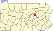 | |
| Townships | ||
| Unincorporated communities | ||
40°58′00″N 76°35′59″W / 40.96667°N 76.59972°W