
Maha Sarakham
มหาสารคาม | |
|---|---|
 Wat Kusuntararam | |
 Flag  Seal | |
| Motto(s): พุทธมณฑลอีสาน ถิ่นฐานอารยธรรม ผ้าไหมล้ำเลอค่า ตักสิลานคร ("Phutthamonthon of Isan. Home of civilisation. Valuable silk. City of Taxila.") | |
 Map of Thailand highlighting Maha Sarakham province | |
| Country | Thailand |
| Capital | Maha Sarakham |
| Government | |
| • Governor | Kiattisak Trongsiri (since October 2020) |
| Area | |
| • Total | 5,607 km2 (2,165 sq mi) |
| • Rank | 39th |
| Population (2019)[2] | |
| • Total | 962,665 |
| • Rank | 24th |
| • Density | 172/km2 (450/sq mi) |
| • Rank | 18th |
| Human Achievement Index | |
| • HAI (2022) | 0.6523 "somewhat high" Ranked 24th |
| GDP | |
| • Total | baht 56 billion (US$1.9 billion) (2019) |
| Time zone | UTC+7 (ICT) |
| Postal code | 44xxx |
| Calling code | 043 |
| ISO 3166 code | TH-44 |
| Website | www |
Maha Sarakham province, also called Maha Sarakham or Mahasarakham (Thai: มหาสารคาม, pronounced [mā.hǎː sǎː.rá.kʰāːm], Northeastern Thai: มหาสารคาม, pronounced [mā.hǎː sǎː.lāː.kʰa᷇ːm]) is one of the 76 provinces (changwat) of Thailand which lies in central northeastern Thailand, also called Isan. Its neighbouring provinces are (from north clockwise): Kalasin, Roi Et, Surin, Buriram, and Khon Kaen.
The town of Maha Sarakham is the provincial capital. It is the home of Mahasarakham University, one of the largest universities in northeast Thailand with 41,000 students (2017),[5] and Rajabhat Mahasarakham University.
YouTube Encyclopedic
-
1/3Views:1 239471355
-
Ban Mo, Maha Sarakham Province
-
ខេត្ត មហាសារខាម /មហាសារ៉ាខាម (Maha Sarakham province), ប្រទេសថៃ #25 - Share4U KH - Thailand
-
SERMTHAI Complex Mahasarakham Province
Transcription
Geography

The province is mostly a plain covered with rice fields. Only in the north and east are there small hills. The province is between 130 and 230 m above sea level. The main river is the Chi. The total forest area is 214 km2 (83 sq mi) or 3.8 percent of provincial area.[1]
History
From the 8th to 10th centuries, several Buddhist relics originated from the ancient town of Champasi which is now in Amphoe Na Dun. Such relics, such as the relic of The Buddha has led speculation of an kingdom being located in the province. During this time and after, the province continued as a Buddhist center in Isan.[6]
Maha Sarakham was originally a satellite town of Roi Et, founded in 1865. The governor of Roi Et sent 9,000 people to populate the new town, and one of his cousins as its governor. In 1868 the central government in Bangkok declared Maha Sarakham a province of its own under the supervision of Bangkok. One of the reasons was that this step weakened the power of Roi Et.[citation needed]
On April 3, 2023, provincial police arrested a 38-year-old man who they seized 322,000 methamphetamine tablets from him. He had been selling these in Ubon Ratchathani province and several other nearby provinces.[7]
Symbols
The provincial seal shows a tree in front of rice fields, symbolizing the richness of resources in the province.
The provincial flag shows the seal in the middle, in a brown horizontal strip. Above and below is a yellow strip. The brown color symbolizes the strength and the perseverance of the people in the province, who live in the rather dry climate; the yellow color symbolizes the robes of Buddhist monks as evidence of the faith of the people.
The provincial tree is the woman's tongue tree (Albizia lebbeck). The tree symbol was assigned to the province in 1994 by Queen Sirikit. The provincial flower is the West Indian jasmine (Ixora).
Administration

Provincial government
The province is divided into 13 districts (amphoes). The districts are further divided into 133 subdistricts (tambons) and 1,804 villages (mubans).
Local government
As of 26 November 2019 there are:[8] one Maha Sarakham Provincial Administration Organisation (ongkan borihan suan changwat) and 19 municipal (thesaban) areas in the province. Maha Sarakham has town (thesaban mueang) status. Further 18 subdistrict municipalities (thesaban tambon). The non-municipal areas are administered by 123 Subdistrict Administrative Organisations - SAO (ongkan borihan suan tambon).[2]
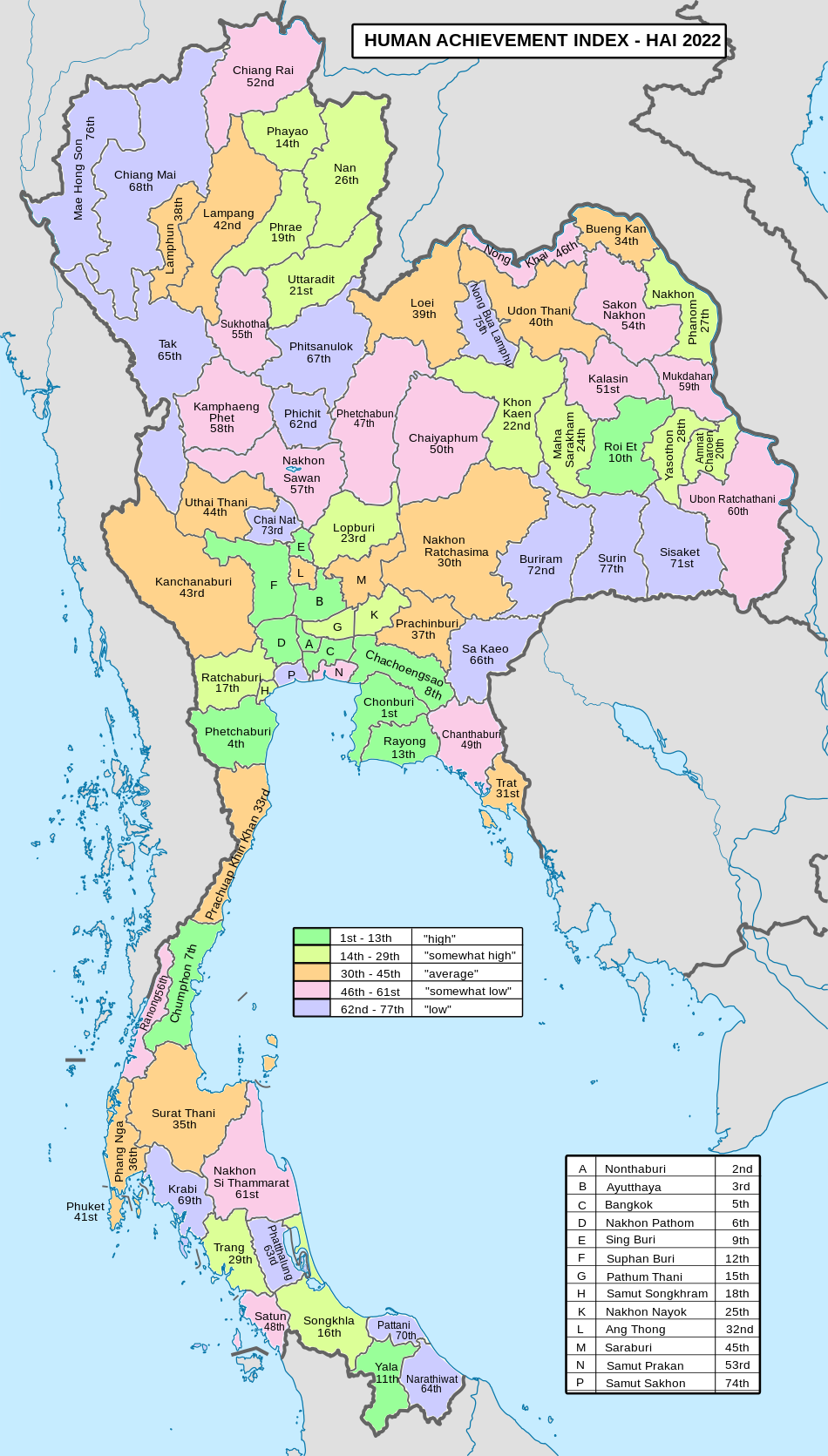
Human achievement index 2022
| Health | Education | Employment | Income |
| 24 | 22 | 55 | 75 |
| Housing | Family | Transport | Participation |

|
 |
||
| 38 | 21 | 30 | 14 |
| Province Maha Sarakham, with an HAI 2022 value of 0.6523 is "somewhat high", occupies place 24 in the ranking. | |||
Since 2003, United Nations Development Programme (UNDP) in Thailand has tracked progress on human development at sub-national level using the Human achievement index (HAI), a composite index covering all the eight key areas of human development. National Economic and Social Development Board (NESDB) has taken over this task since 2017.[3]
| Rank | Classification |
| 1 - 13 | "high" |
| 14 - 29 | "somewhat high" |
| 30 - 45 | "average" |
| 46 - 61 | "somewhat low" |
| 62 - 77 | "low" |
| Map with provinces and HAI 2022 rankings |
|
References
- ^ a b "ตารางที่ 2 พี้นที่ป่าไม้ แยกรายจังหวัด พ.ศ.2562" [Table 2 Forest area Separate province year 2019]. Royal Forest Department (in Thai). 2019. Retrieved 6 April 2021, information, Forest statistics Year 2019, Thailand boundary from Department of Provincial Administration in 2013
{{cite web}}: CS1 maint: postscript (link) - ^ a b รายงานสถิติจำนวนประชากรและบ้านประจำปี พ.ส.2562 [Statistics, population and house statistics for the year 2019]. Registration Office Department of the Interior, Ministry of the Interior. stat.bora.dopa.go.th (in Thai). 31 December 2019. Retrieved 26 February 2020.
- ^ a b "ข้อมูลสถิติดัชนีความก้าวหน้าของคน ปี 2565 (PDF)" [Human Achievement Index Databook year 2022 (PDF)]. Office of the National Economic and Social Development Council (NESDC) (in Thai). Retrieved 12 March 2024, page 56
{{cite web}}: CS1 maint: postscript (link) - ^ "Gross Regional and Provincial Product, 2019 Edition". <>. Office of the National Economic and Social Development Council (NESDC). July 2019. ISSN 1686-0799. Retrieved 22 January 2020.
- ^ "MSU at a glance". Mahasarakham University. Retrieved 6 December 2020.
- ^ ไทย (2011-08-20). ".thailangr: Phra That Na Dun: Buddhist Park of Isan". .thailangr. Retrieved 2023-04-10.
- ^ matichon (2023-04-03). "รวบหนุ่มรับหน้าที่ 'นักบิน' วางยาบ้า ตามจุดนัดหมายพื้นที่ภาคอีสาน ของกลางกว่า3แสนเม็ด". มติชนออนไลน์ (in Thai). Retrieved 2023-04-10.
- ^ "Number of local government organizations by province". dla.go.th. Department of Local Administration (DLA). 26 November 2019. Retrieved 10 December 2019.
42 Maha Sarakham: 1 PAO, 1 Town mun., 18 Subdistrict mun., 123 SAO.
External links
 Maha Sarakham travel guide from Wikivoyage
- About Maha Sarakham, Tourism Authority of Thailand (TAT)
- Provincial website (Thai only)
- Maha Sarakham provincial map, coat of arms and postal stamp
- Photos of Maha Sarakham, 1963
16°11′5″N 103°18′2″E / 16.18472°N 103.30056°E
Places adjacent to Maha Sarakham province | ||||||||||||||||
|---|---|---|---|---|---|---|---|---|---|---|---|---|---|---|---|---|
| ||||||||||||||||
| International | |
|---|---|
| National | |
| Other | |