
| Magra | |
|---|---|
 The mouth of the Magra | |
 | |
| Location | |
| Country | Italy |
| Physical characteristics | |
| Source | |
| • location | Between Monte Borgognone and Monte Tavola |
| • elevation | 1,200 m (3,900 ft) |
| Mouth | Ligurian Sea |
• coordinates | 44°02′53″N 9°59′15″E / 44.0481°N 9.9876°E |
• elevation | 0 m (0 ft) |
| Length | 62 km (39 mi) |
| Basin size | 1,686 km2 (651 sq mi) |
| Discharge | |
| • average | 40 m3/s (1,400 cu ft/s) |
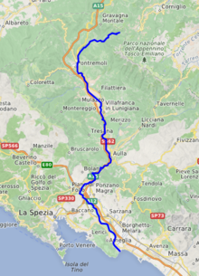
The Magra is a 62-kilometre (39 mi) long river of Northern Italy, which runs through Pontremoli, Filattiera, Villafranca in Lunigiana and Aulla in the province of Massa-Carrara (Tuscany); Santo Stefano di Magra, Vezzano Ligure, Arcola, Sarzana and Ameglia in the province of La Spezia (Liguria).
In Roman times, it was known as the Macra and marked the eastern boundary of the territory of Liguria.
The river's drainage basin occupies around 1,700 km2 (660 sq mi).[citation needed] Its most important tributary is the Vara which joins the Magra from the right within the commune of Santo Stefano di Magra.
YouTube Encyclopedic
-
1/3Views:1 683 487317 3359 840
-
COMO GANHEI + BUMBUM + PERNAS + MASSA MAGRA + MÚSCULOS EM 10 DIAS!POTENTE E BARATO.
-
Oumguil:Aymano Magra
-
Sviluppare la massa magra - Dott.sa Susan Bowerman
Transcription
Caprigliola bridge collapse
In April 2020 a 260 metre long road bridge across the Magra at Albiano Magra near Aulla collapsed. Very few vehicles were using the bridge at the time due to the coronavirus lockdown then in force, and only two people were injured.[1][2][3]
Regional Natural Park of Montemarcello-Magra-Vara
Since 1995 an area of 4,320.8 hectares (10,677 acres) surrounding the Magra and Vara rivers is protected by a natural park of the regione Liguria, placed near the border with the Tuscany region. Due its biodiversity, the Regional Natural Park of Montemarcello-Magra-Vara is part of the Natura 2000 European network.[4][5][6]
See also
References
- ^ "Italy bridge collapse: Two drivers survive". BBC News. 8 April 2020. Retrieved 8 April 2020.
- ^ "Lockdown keeps casualty figure low as Italian bridge collapses". The Guardian. London. 8 April 2020. Retrieved 9 April 2020.
- ^ "Bridge Collapses in Italy, Newest Crumbling Infrastructure". The New York Times. 8 April 2020. Retrieved 9 April 2020.
- ^ "Rete Natura 2000" (in Italian and English).
- ^ "SIC e ZPS in Liguria » La Spezia » Parco della Magra - Vara" (in Italian and English).
- ^ "La Biblioteca dell'Ente Parco di Montemarcello-Magra" (in Italian). Archived from the original on July 30, 2021.
External links
![]() Media related to Magra River at Wikimedia Commons
Media related to Magra River at Wikimedia Commons
| National | |
|---|---|
| Geographic | |
This Liguria location article is a stub. You can help Wikipedia by expanding it. |