
Mékinac (RCM) | |
|---|---|
 | |
 | |
| Coordinates: 46°49′N 72°31′W / 46.817°N 72.517°W | |
| Country | |
| Province | |
| Region | Mauricie |
| Effective | January 1, 1982 |
| County seat | Saint-Tite |
| Municipalities | |
| Government | |
| • Type | Prefecture |
| • Prefect | Alain Vallée |
| Area | |
| • Total | 5,554.90 km2 (2,144.76 sq mi) |
| • Land | 5,222.10 km2 (2,016.26 sq mi) |
| Population (2016)[2] | |
| • Total | 12,358 |
| • Density | 2.4/km2 (6/sq mi) |
| • Change 2011-2016 | |
| • Dwellings | 8,324 |
| Time zone | UTC−5 (EST) |
| • Summer (DST) | UTC−4 (EDT) |
| Area code(s) | 418 and 581 |
| Website | Official web site |
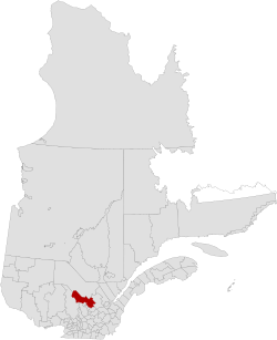
Mékinac (French: [mekinak]) is a regional county municipality (RCM) of 5,607 km² located in the administrative region of Mauricie, along the Saint-Maurice River, which also crosses the RCM from one end to the other, and the Matawin River, a tributary of the Saint-Maurice. Located in the province of Quebec, Canada.
Established in January 1982, the Mékinac RCM is made up of 10 or 11 municipalities depending on the source, Saint-Tite is the most populous city, four unorganized territories occupying two-thirds of its surface area.[3][4]
Geography
Eleven municipalities and Unorganized Territories make up the RCM de Mékinac. It is distinguished by a huge forest dotted with more than 2,000 lakes, agriculture adapted to the environment, popular holiday sites and picturesque villages. The Mékinac RCM is located on both sides of the Saint-Maurice River, between the upper and central Mauricie regions. It is adjacent to the RCMs of Matawinie, Maskinongé, Centre-du-Québec, Les Chenaux, Portneuf and Haut-Saint-Maurice. As part of the Mauricie administrative region, it is divided into two provincial electoral districts; Portneuf and Laviolette, while the federal riding is Champlain.[4]
Concentrated in the southeastern tip of the territory, agricultural land corresponds to the limit of the invasion of the Champlain Sea. There is also some land cleared for cultivation in certain settlement hamlets scattered between the Laurentian Mountains, on the banks of the Mékinac River, and the northern portion of the Batiscan River.
The forest covers nearly 93% of the total area of the Mékinac RCM. It was the raison d'être of the colonization of the territory and still supports 20% of all jobs.
Forest ownership is shared between: the provincial government (public lands), the federal government (La Mauricie National Park) and approximately 587 private landowners, with a proportion of 79%, 1% and 20% of the forest respectively.[4]
Hydrology: 3 major rivers - 4,665 lakes
The Saint-Maurice River, the Batiscan River and the Sainte-Anne River flow from west to east on the territory of the MRC de Mékinac, the hydrographic network includes:
- 2,964 km of permanent watercourses
- 2,863 km of intermittent rivers for a total of 5827 km.
- Nearly 38% (2,241 km) of this system is privately owned, with 791 km (35%) of permanent watercourses and 1,450 km of intermittent (65%) watercourses.
The Mékinac RCM has 4,665 lakes for a total area of 34,272.8 ha (342.7 km2).
- The number of lakes of one hectare or more is 1,869.
- Lakes of less than one hectare account for nearly 60% (2,797 ha) of all bodies of water in the MRC.
- The largest is Lake Mékinac measuring 2,297 ha (23.0 km2). It is divided between the Mékinac RCM and the La Tuque agglomeration, where most (79.9%) is in the Mékinac RCM.
- Most of the lakes (53.4%) in the MRC are classified as very small (1 to 5 ha) according to Bazoge and Blais (2005) with a surface area of less than 5 ha.
- Conversely, there are only three very large lakes (625 ha or more) in the RCM, lakes Mékinac, Normand and Salone. Source: MRC de Mékinac Regional Plan for Wetlands and Bodies of Water[5]
Photos
The Mauricie region river's Saint-Maurice, Batiscan, Sainte-Anne (Les Chenaux) and their tributaries cross the territory of Mékinac RCM
- Three majors rivers
-

-

-

- Permanent watercourses tributary to major rivers
-
 Dam, Turtle River, Lac-à-la-Tortue sector, Shawinigan
 -
 South Mékinac River, Petit Lac du Castor Road, Hérouxville
 -
 Rivière des Envies, Goulet Falls, Saint-Stanislas-de-Kostka
 -
![Rivière des Envies, from bridge P-03960, steel-wood (1918),[6] rang du Haut-du-Lac Nord, Saint-Tite](/wikipedia/commons/thumb/e/e1/Saint_Tite_089.jpg/240px-Saint_Tite_089.jpg)
Toponymy
Mékinak, (Algonquin). — Lake, river and township of Champlain County. The Mékinac River flows into the Saint-Maurice twelve miles upstream of Les Piles, and 57 miles from Trois-Rivières.
A few spell it Mékinac, but the geographic office of Canada considers the ending in k. This word means turtle, and according to Father N. Caron, it was given because of a mountain that had more or less the shape of a turtle.
In the Cree idiom, this word also has the same meaning. In his lexicon of the Algonquin language, Father Cuoq translates Micinimakina as "big turtle" and brings this word of mici which would have lengthened in micini, and mikinak.
—Translate from french, source: Publications de la Société du Parler français au Canada 1906[7]
The Algonquin Mikinak means turtle. Native Americans often referred to places based on the naming of the animal kingdom. Once well known, the toponym made it possible to refer to the same place in conversations. The designation Mikinak would have been assigned to a nearby mountain. However, it remains possible that the abundance of turtles in this portion of the territory explains this name[8]
However, the name is also similar to the historical Algonquin word mekanâc, pronounced /me:kana:ʃ/, meaning "small path". The toponym Mekinac was assigned to the Mékinac River, Mékinac Lake, at Mékinac (township), in the ex-municipality of Saint-Joseph-de-Mékinac, Quebec, and town of Saint-Roch-de-Mékinac.
The foothills of the Laurentians are located in Saint-Tite. The Laurentide hinterland is developed for hunting and fishing; it includes, among others, the Tawachiche, Gros-Brochet and Chapeau-de-Paille zecs, as well as the Saint-Maurice Wildlife Reserve[3]
Municipalities of RCM Mékinac
The RCM has 14 entities
| Municipality | Status | Surface km2 |
Population (2011)[9] | Density hab./km2 |
|---|---|---|---|---|
| Grandes-Piles | Village municipality | 120.53 | 361 | 3.0 |
| Hérouxville | Parish municipality | 53.04 | 1,340 | 25.3 |
| Lac-aux-Sables | Parish municipality | 270.38 | 1,373 | 5.1 |
| Lac-Boulé | Unorganized area | 22.96 | 0 | 0.0 |
| Lac-Masketsi | Unorganized area | 213.29 | 0 | 0.0 |
| Lac-Normand | Unorganized area | 2,038.09 | 5 | 0.0 |
| Notre-Dame-de-Montauban | Municipality | 165.37 | 747 | 4.5 |
| Rivière-de-la-Savane | Unorganized area | 1,088.02 | 0 | 0.0 |
| Saint-Adelphe | Parish municipality | 137.45 | 952 | 6.9 |
| Saint-Roch-de-Mékinac | Parish municipalityh | 144.59 | 438 | 3.0 |
| Saint-Séverin | Parish municipality | 62.28 | 860 | 13.8 |
| Saint-Tite | City | 92.53 | 3,880 | 41.9 |
| Sainte-Thècle | Municipality | 213.46 | 2,478 | 11.6 |
| Trois-Rives | Municipality | 603.94 | 490 | 0.8 |
| Total | 5,226.08 | 12,919 | 2.47 | |
- Some municipalities of the MRC
-
 Rivière à la Tortue, rang Saint-Pierre Sud, Hérouxville
 -
 Batiscan River, spring flood, Notre-Dame-de-Montauban
 -
 Patrick Douville Fire Station (1930), Principale Street, Saint-Adelphe
 -
 Rivière des Envies, chemin des Moulins, Saint-Séverin
 -
 Catholic Church and Presbytery, Notre-Dame Street, Saint-Tite
Between 2006 and 2011, the population grew by 2.0%. The RCM has 8,237 private dwellings whose 6,096 private dwellings are occupied by usual residents. The median age of the population is 52.6 years old. Statistics Canada reports that in 2011, 88.5% of the population was aged 15 and over, meanings 11,430 individuals (including 5700 men and 5730 women), divided into 3,940 private households. This census indicates that 2,070 people lived alone. Of this population, 1,880 individuals have mastered both French and English, or 14.6%.[10]
Transportation
Access routes
Highways and numbered routes that run through the municipality, including external routes that start or finish at the county border:[11]
|
|
See also
- Atlas de l’eau, Ministère de l’Environnement, de la Lutte contre les changements climatiques, de la Faune et des Parcs Québec (French)
- Plan directeur de l’eau de la rivière Batiscan, Société d’aménagement et de mise en valeur du bassin de la Batiscan (SAMBBA) (2015), 359 pages (French)
- Cartographie et géomatique, MRC de Mékinac (French)
- List of regional county municipalities and equivalent territories in Quebec(French)
- Batiscanie, Quebec
- Batiscan River
- Rivière des Envies
- North Mékinac River
- South Mékinac River
- Rivière du milieu (Mékinac)
- Rivière aux eaux mortes (Mékinac)
- Tawachiche River
- Tawachiche West River
- Pierre-Paul River
- Saint-Maurice River
- Mékinac River
- Mékinac Lake
- Missionary Lake
- Lake Jesuit
- Lake Traverse (Mékinac)
- Regional County Municipality
- Irénée-Marie Ecological Reserve
- Grande-Anse (Mékinac) (hamlet)
References
- ^ a b Ministère des Affaires municipale et des Régions du Québec. "Mékinac - Résertoire des municipalités". Archived from the original on 2013-12-20. Retrieved 2008-01-11.
- ^ a b "Census Profile, 2016 Census Mékinac, Municipalité régionale de comté [Census division], Quebec". Statistics Canada. Retrieved December 8, 2019.
- ^ a b "Mékinac". Commission de toponymie Quebec (in French). Government of Quebec. 1985-03-07. Retrieved 2023-11-24.
Along the Saint-Maurice River
- ^ a b c "Regional County Municipality of Mékinac Revised Land Use Plan" (PDF) (in French). Mékinac. 2008. p. 423. Retrieved 2023-11-24.
Developer tool
- ^ Andrée-Ann Cloutier (2021-09-29). "Plan régional des milieux humides et hydriques- MRC de Mékinac- Document de travail" (PDF) (in French). Société d'aménagement et de mise en valeur du bassin de la Batiscan (SAMBBA). p. 67. Retrieved 2023-11-24.
Bassin versant Saint-Maurice
- ^ Ministère des Transports et de la Mobilité durable. "Inventaire et inspection des structures" (in French). Government of Quebec. Retrieved 2023-11-26.
Location and description of the condition of bridges, culverts, retaining walls and tunnels
- ^ Rouillard, Eugene. "Noms géographiques de la province de Québec et des provinces maritimes empruntés aux langues sauvages". Bibliothèque et Archives nationales du Québec. Publications de la Société du Parler français au Canada 1906. p. 61. Retrieved 19 June 2023.
- ^ "Saint-Roch-de-Mékinac, origin and signification". Commission de toponymie Quebec (in French). Quebec Gouvernement. Retrieved 20 June 2023.
- ^ Recensement de 2011 du Canada
- ^ "Mékinac Regional County Municipality (Code 2435) Census Profile". 2011 census. Government of Canada - Statistics Canada.
- ^ Official Transport Quebec Road Map
Adjacent Counties & Equivalent Territories | |
|---|---|
| Regional county municipalities and equivalent territories | |
|---|---|
| Municipalities | |
| International | |
|---|---|
| Geographic | |