To install click the Add extension button. That's it.

The source code for the WIKI 2 extension is being checked by specialists of the Mozilla Foundation, Google, and Apple. You could also do it yourself at any point in time.

4,5
Kelly Slayton
Congratulations on this excellent venture… what a great idea!
Alexander Grigorievskiy
I use WIKI 2 every day and almost forgot how the original Wikipedia looks like.
Live Statistics
English Articles
Improved in 24 Hours
Added in 24 Hours
What we do. Every page goes through several hundred of perfecting techniques; in live mode. Quite the same Wikipedia. Just better.
.
Leo
Newton
Brights
Milds

M'bour Department

From Wikipedia, the free encyclopedia

M'bour
Location in the Thiès Region
Country Senegal
RegionThiès Region
CapitalM'bour
Area
 • Total1,607 km2 (620 sq mi)
Population
 (2023 census)
 • Total937,189
 • Density580/km2 (1,500/sq mi)
Time zoneUTC+0 (GMT)

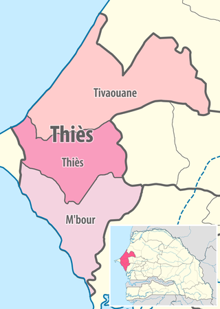
M'bour Department is one of the 45 departments of Senegal, one of three in the Thiès Region. Its capital is M'Bour.[1]

The department has 8 urban communes; Joal-Fadiouth, Mbour, Nguékhokh, Thiadiaye, Saly Portudal, Ngaparou, Somone and Popenguine. Since 2018, the department will be creating its first Planned urban city, named Akon City or in French, Ville d'Akon.

The rural districts (communautés rurales) are:

  • Arrondissement of Fissel:
    • Fissel
    • Ndiaganiao
  • Arrondissement of Séssène:
    • Séssène
    • Nguéniène
  • Arrondissement de Sindia:
    • Sindia
    • Malicounda
    • Diass

Historic sites [2]

  • Residence at Popenguine and the Cap de Naze
  • Tumuli of the forest of Bandia
  • Church and Sanctuary of Popenguine
  • Fadiouth Island, Cemetery Island and Granaries on stilts
  • Fort of the Comptoir of Saly Portudal
  • Thiémassas prehistoric site
  • Little Seminary of Ngazobil
  • Senghor family house at Joal
  • Ndianda church
  • Sangomar, place of the Sereer cult, at Palmarin
  • Fangool and cannon at Mbalamson
  • Sereer Tumulus of Mbafaye at Godaguène Fissel

References

  1. ^ "Découpage administratif". Découpage administratif. senegalaisement.com. Retrieved 16 March 2011.
  2. ^ List of historic sites

14°27′09″N 17°08′15″W / 14.45250°N 17.13750°W / 14.45250; -17.13750


This page was last edited on 28 January 2024, at 12:29
Basis of this page is in Wikipedia. Text is available under the CC BY-SA 3.0 Unported License. Non-text media are available under their specified licenses. Wikipedia® is a registered trademark of the Wikimedia Foundation, Inc. WIKI 2 is an independent company and has no affiliation with Wikimedia Foundation.