
Ludewa
Wilaya ya Ludewa (Swahili) | |
|---|---|
 Tea farms in the South Tanzania Highlands in the Ludewa, Njombe | |
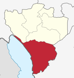 Location in Njombe Region | |
| Coordinates: 10°00′S 34°45′E / 10.000°S 34.750°E | |
| Country | |
| Region | Njombe Region |
| District | Ludewa District |
| Established[1] | 31 December, 1983 |
| Government | |
| • Type | Council |
| • Chairman | Wise Charles Mgina |
| • Director | Sunday N. Deogratias |
| Area [2]: 2 | |
| • Total | 8,397 km2 (3,242 sq mi) |
| Population | |
| • Total | 137,520 |
| • Density | 16/km2 (42/sq mi) |
| Time zone | EAT |
| Postcode[4] | 594xx |
| Area code | 026 |
| Website | District Website |
Ludewa District is one of six districts in the Njombe Region in Tanzania, East Africa. Prior to 2012, the district was one of the seven districts of Iringa Region. The town of Ludewa is the administrative seat of the district. A hospital is located in the city. The district is bordered to the north by the Njombe Rural District and Makete District, to the southeast by the Ruvuma Region and to the southwest by the country of Malawi across Lake Nyasa.[5][6][7]: 6
In 2016 the Tanzania National Bureau of Statistics report there were 137,520 people in the district, from 133,218 in 2012.[3]: 167-168 [8]: 204
Geography
The district has a wide shore of Lake Nyasa with beaches in Lupingu and Manda and the mouth of Ruhuhu River. The district covers and area of 8,397 square kilometres (3,242 sq mi), of which 6,325 km2 (2,442 sq mi) that is 75% is land, and 2,072 km2 (800 sq mi) that is 25% is water.[2]: 2
Economy
The primary occupations are livestock raising, subsistence farming, and fishing which encompasses 78% of peoples livelyhoods.[9]: 28
Mining
The Liganga iron ore mine in Ludewa is a $1.8 billion USD project to mine iron ore and manufacture steel sheets. The complex is to produce one mt/y of steel, iron, titanium dioxide, and vanadium pentoxide.[10]: 31
There is a small amount of artisanal mining of gold and gem quality green tourmaline.[11]: 114
Administrative subdivisions
Ludewa District is administratively divided into five divisions, twenty-six wards, with 77 villages, and 337 vitongoji.[12][2]: 2
Constituencies
For parliamentary elections, Tanzania is divided into constituencies. As of the 2010 elections Ludewa District had one constituency:[13]
- Ludewa Constituency
Wards
Below are the 26 wards as follows:[3]: 167-168 [4]
- Ibumi
- Iwela
- Kilondo
- Lifuma
- Luana
- Ludende
- Ludewa
- Lugarawa
- Luilo
- Lumbila
- Lupanga
- Lupingu
- Madilu
- Madope
- Makonde
- Manda
- Masasi
- Mavanga
- Mawengi
- Milo
- Mkongobaki
- Mlangali
- Mundindi
- Nkomang'ombe
- Ruhuhu
- Lubonde
Gallery
-
 Raw Tea bags before processing at Luponde tea factory in the rear 1992
 -
 Coal mining in the Ludewa District near the Lake Nyassa
 -
 Liganga iron mountain in Ludewa District
 -
 A ferry across the Ruhuhu river in Tanzania
References
- ^ "Historia". ludewadc.go.tz (in Swahili). Ludewa District: Halmashauri ya Wilaya ya Ludewa. Archived from the original on 18 June 2022. Retrieved 2 September 2022.
- ^ a b c "Socio-economic Profile" (PDF). ludewadc.go.tz. Dar es Salaam, Tanzania: National Bureau of Statistics (Tanzania). 2009. Archived (PDF) from the original on 18 June 2022. Retrieved 3 September 2022.
- ^ a b c d 2016 Makadirio ya Idadi ya Watu katika Majimbo ya Uchaguzi kwa Mwaka 2016, Tanzania Bara [Population Estimates in Administrative Areas for the Year 2016, Mainland Tanzania] (PDF) (Report) (in Swahili). Dar es Salaam, Tanzania: National Bureau of Statistics. 1 April 2016. Archived (PDF) from the original on 27 December 2021. Retrieved 3 July 2022.
- ^ a b "Njombe Postcodes" (PDF). Tanzania Communications Regulatory Authority. Archived (PDF) from the original on 29 July 2022. Retrieved 30 August 2022.
- ^ Ludewa District (Approved) at GEOnet Names Server, United States National Geospatial-Intelligence Agency
- ^ Staff (9 March 2012). "Tanzania: State Gazettes New Regions, Districts". Daily News. Dar es Salaam, Tanzania. Archived from the original on 23 August 2012.
- ^ Ludewa District Strategic Plan (PDF) (District Plan). Ludewa District: Ludewa District. 2017. Archived (PDF) from the original on 18 June 2022. Retrieved 2 September 2022.
- ^ 2012 Population and Housing Census - Population Distribution by Administrative Areas (PDF) (Report). Dar es Salaam, Tanzania: National Bureau of Statistics. 1 March 2013. Archived (PDF) from the original on 26 March 2022. Retrieved 3 July 2022.
- ^ Lupembe, Gervas A. (1 January 2017). Contribution of Farmers' Network to Income Poverty Reduction of Ludewa District (PDF) (Thesis). Mzumbe, Tanzania: Mzumbe University. Archived (PDF) from the original on 3 September 2022.
- ^ "TEITI Report, 2017 to 2018" (PDF). teiti.go.tz. Mzumbe, Tanzania: Mzumbe University. Archived (PDF) from the original on 3 September 2022. Retrieved 3 September 2022.
- ^ "Socio-Economic Profile of Iringa Region" (PDF) (second ed.). The Planning Commission, Dar es Salaam, and The Regional Commissioner's Office, Iringa. May 2007. Archived from the original (PDF) on 13 November 2010. Retrieved 7 September 2012. (missing front cover)
- ^ "Takwimu". ludewadc.go.tz (in Swahili). Ludewa District: Halmashauri ya Wilaya ya Ludewa. Archived from the original on 18 June 2022. Retrieved 2 September 2022.
- ^ "Organisations located in Ludewa District - Tanzania". African Development Information. Archived from the original on 23 February 2018. Retrieved 7 September 2012.
| International | |
|---|---|
| National | |