
| Districts of Punjab | |
|---|---|
 Districts of Punjab with their names as of 2023. Colors correspond to divisions | |
| Location | Punjab, Pakistan |
| Number | 41 (as of 2022) |
| Populations | 1,156,954 (Hafizabad District) – 11,119,985 (Lahore District) |
| Areas | 1,772 square kilometres (684 sq mi) (Lahore District) – 24,830 square kilometres (9,590 sq mi) (Bahawalpur District) |
| Government | |
| Subdivisions | |
The province of Punjab, the most populous province of Pakistan and the second-largest province by area, is divided into 41 districts and 11 divisions(as of January 2023).[1] Below, you will find an overview of the recent history of districts in Punjab, a map showing each district, the divisions of Punjab and their districts, and a list showing each district's name, the division the district belongs to, the district's area, the location of the district's headquarters, the district's population and population density (in 2017), the average annual population growth rate of each district (between 1998 and 2017), and a map showing each district's location.
YouTube Encyclopedic
-
1/5Views:4 4522 90745 274445527
-
Districts and Tehsils of Punjab | 42 Districts of Punjab (Updated 2023)
-
Districts of Punjab Ranked By area GK of Pakistan
-
List of all district of punjab Population wise I GK of Pakistan
-
Punjab district names | How many districts of Punjab Pakistan | Punjab k zilo k name Punjab azla
-
List of District and Tehsils of Province Punjab | Punjab district name | 36 Districts of Punjab
Transcription
History
Colonial Times
1868–1901
Districts and Divisions were both introduced in Punjab as administrative units by the British when Punjab became a part of British India, and ever since then, they have formed an integral part in the civil administration of the Punjab (this region today also covers parts of Khyber Pakhtunkhwa, the entire Islamabad Capital Territory, and parts of the Indian States of Chandigarh, Delhi, Haryana, Himachal Pradesh, and Punjab). At the time of Punjab's second census, which took place in 1868, the Punjab was divided into 32 districts, under 10 divisions.[2] The administrative setup of the region was as follows (districts and divisions which do not exist anymore are and are in Pakistani Punjab are in red writing, districts and divisions which were (at least mostly) given to India during the Partition of India are in orange writing, districts and divisions which are (at least mostly) currently in Pakistan's Khyber Pakhtunkhwa province are in green writing, and districts and divisions which have been renamed and are in Pakistani Punjab are in blue writing):[3]
- Ambalah Division[4][5]
- Ambalah District
- Ludhiana District
- Simla District
- Amritsar Division[6]
- Amritsar District
- Gurdaspur District
- Sialkot District
- Delhi Division
- Delhi District
- Gurgaon District
- Karnal District
- Derajat Division
- Bannu District
- Dera Ghazi Khan District
- Dera Ismail Khan District
- Hissar Division
- Hissar District
- Rohtak District
- Sirsah District
- Jalandhar Division
- Hoshiarpur District
- Jalandhar District
- Kangra District
- Lahore Division
- Firozpur District
- Gujranwala District
- Gujrat District
- Lahore District
- Multan
- Jhang District
- Montgomery District
- Multan District
- Muzaffargarh District
- Peshawar Division
- Hazara District
- Kohat District
- Peshawar District
- Rawalpindi Division
- Jhelam District
- Rawalpindi District
- Shahpur District
The exact same setup was in use at the time of the 1881 Census of Punjab as well.[7]
By the 1901 census, the 10 revenue divisions that had been in place since 1868 had also been reorganized into only 5 larger divisions: Delhi, Jalandhar, Lahore, Multan, and Rawalpindi, and Sirsah District had been absorbed into Hissar District.[8]
1901–1911
Between 1901 and 1911, many changes occurred to Punjab's administrative map. On 25 October 1901, after the 1901 census was taken, the Punjab province was divided into two separate entities: Punjab and the North-West Frontier Province. The North-West Frontier Province consisted of the three districts of Hazara, Kohat, and Peshawar, the Bannu and Marwat Tehsils of Bannu District (which then became Bannu District), and the Dera Ismail Khan, Kulachi, and Tank Tehsils of Dera Ismail Khan District (which then became Dera Ismail Khan District). The tehsils of Dera Ismail Khan and Bannu Districts which were not placed into the North-West Frontier Province became Mianwali District, placed in Multan.[8] In 1904, Attock District was created out of parts of Rawalpindi District and Jhelum District, and Lyallpur District was created out of parts of Gujranwala, Jhang, and Montgomery Districts. In 1909, Montgomery District transferred from Lahore Division to Multan, and Mianwali District transferred from Multan to Rawalpindi Division. This all meant that at the time of Punjab's 1911 Census, Punjab had 29 districts split among 5 divisions. The administrative setup of the region was as follows (districts and divisions which do not exist anymore are and are in Pakistani Punjab are in red writing, districts and divisions which were (at least mostly) given to India during the Partition of India are in orange writing, and districts and divisions which have been renamed and are in Pakistani Punjab are in blue writing):[9]
- Delhi Division
- Ambala District
- Delhi District
- Gurgaon District
- Hissar District
- Karnal District
- Rohtak District
- Simla District
- Jalandhar Division
- Ferozpur District
- Hoshiarpur District
- Jalandhar District
- Kangra District
- Ludhiana District
- Lahore Division
- Amritsar District
- Gujranwala District
- Gurdaspur District
- Lahore District
- Gujrat District
- Sialkot District
- Multan Division
- Dera Ghazi Khan District
- Jhang District
- Lyallpur District
- Montgomery District
- Multan District
- Muzaffargarh District
- Rawalpindi Division
- Attock District
- Jhelum District
- Mianwali District
- Rawalpindi District
- Shahpur District
1911–1947
In late 1911, the imperial capital of British India was moved from Calcutta (today Kolkata) to Delhi. The district was reorganized as its own province that year, decreasing the number of districts in Punjab to 28. After the creation of Delhi Province, Delhi Division went by the name "Ambala Division". In 1919, Sheikhupura District was created from parts of Gujranwala and Lahore Districts and placed in Lahore Division. This meant that the number of districts and divisions in the province was the same in 1921 as it was in 1911, except Ambala Division was one district smaller and Lahore Division was one district larger, although Lahore Division hadn't changed much in area and population. The administrative setup of Punjab was as follows (districts and divisions which do not exist anymore are and are in Pakistani Punjab are in red writing, districts and divisions which were (at least mostly) given to India during the Partition of India are in orange writing, and districts and divisions which have been renamed and are in Pakistani Punjab are in blue writing):[10]
- Ambala Division
- Ambala District
- Gurgaon District
- Hissar District
- Karnal District
- Rohtak District
- Simla District
- Jalandhar Division
- Ferozpur District
- Hoshiarpur District
- Jalandhar District
- Kangra District
- Ludhiana District
- Lahore Division
- Amritsar District
- Gujranwala District
- Gurdaspur District
- Lahore District
- Gujrat District
- Sheikhupura District
- Sialkot District
- Multan Division
- Dera Ghazi Khan District
- Jhang District
- Lyallpur District
- Montgomery District
- Multan District
- Muzaffargarh District
- Rawalpindi Division
- Attock District
- Jhelum District
- Mianwali District
- Rawalpindi District
- Shahpur District
This exact setup existed in Punjab through the 1931 census,[11] 1941 census,[12] and all the way up to the partition of India and the independence of India and Pakistan.
Post-Independence
1947–1954
At the time of the Partition of India, Punjab was split religiously. As of the 1941 census, Punjab had a population that was 53.22% Muslim (mostly concentrated in the Western regions of the province), 29.11% Hindu (mostly concentrated in the Eastern regions of the province), and 14.91% Sikh (mostly concentrated in the center of the province, around Amritsar and Lahore).[12] Because of this divide, Punjab was split into East Punjab, which would have a Hindu/Sikh majority and would be placed in India, and West Punjab, which would have a Muslim majority and would be placed in Pakistan. The line dividing the two was placed by Cyrial Radcliffe, and the line he drew would come to be known as the Radcliffe line.[13]
In the partition, Multan Division and Rawalpindi Division, which were 75.43% and 85.52% Muslim respectively, were entirely given to Pakistan. Each district and each tehsil in both of these divisions had a proportion of Muslims over 50%.[13][12]
Ambala Division was given to India, being only 28.07% Muslim. Every district in Ambala Division had a non-Muslim majority, and all tehsils but two had non-Muslim majorities (Ferozpur Jhirka and Nuh Tehsils in Gurgaon District had Muslim proportions of 78.79% and 57.88% respectively, but they were very far from all the other Muslim majority districts and tehsils in the Punjab, being next to Delhi).[13][12]
Jalandhar Division was entirely given to India as well, and each of its districts had a non-Muslim majority. Four Tehsils in this division, though, Ferozpur (55.25% Muslim) and Zira (65.26% Muslim) Tehsils in Ferozpur District, and Jalandhar (51.16% Muslim) and Nakodar (59.41% Muslim) Tehsils in Jalandhar District all had Muslim majorities and bordered Pakistan.[13][12]
In Lahore Division, Gujranwala (70.45% Muslim), Sheikhupura (63.62% Muslim), and Sialkot (62.18% Muslim) Districts were all entirely given to Pakistan. In these three districts, each tehsil also had a Muslim majority. Amritsar District (46.52% Muslim) was entirely given to India, despite having one tehsil (Ajnala Tehsil at 59.46% Muslim) bordering other Muslim-majority tehsils and districts that was also Muslim-majority. Lahore District and Gurdaspur Districts, both Muslim majority (60.62% Muslim and 51.14% Muslim respectively) were the only two districts in Punjab that were split. In Gurdaspur District, which had four tehsils, three tehsils were majority Muslim (Batala, Gurdaspur, and Shakargarh Tehsils at 55.07%, 52.16%, and 51.32% Muslim respectively) and one tehsil was majority non-Muslim (Pathankot Tehsil at 38.89% Muslim). One tehsil in Gurdaspur District, Shakargarh Tehsil, was given to Pakistan and placed in Sialkot District, and the other three tehsils were all given to India despite forming a contiguous boundary. Lahore District had three tehsils, Chunian, Lahore and Qasur, all of which were Muslim majority (60.85%, 62.12%, and 57.19% Muslim respectively). While Chunian and Lahore Tehsils were entirely given to Pakistan, Qasur Tehsil was divided into two parts, which the larger part going to India. This was under the grounds of "protecting Amritsar city".[13][12]
In the end, fifteen districts of Punjab went entirely to Pakistan, all of which were Muslim majority; twelve districts of Punjab went entirely to India, all of which were non-Muslim-majority, and the two districts of Gurdaspur and Lahore, both of which were Muslim majority, were split between India and Pakistan. At the tehsil level, though, eight Muslim-majority tehsils which were contiguous with Pakistan were given to India, while not a single non-Muslim-majority tehsil was given to Pakistan. This left sixteen districts in Pakistani Punjab, that were split up into three divisions. No changes to this setup had occurred up to the time of the 1951 census (except for Attock District being renamed Campbellpur District). The administrative setup of Pakistani Punjab in 1951 was as follows (districts and divisions which do not exist anymore are in red writing, and districts and divisions which still exist, but have been renamed are in blue writing):[14]
- Lahore Division
- Gujrat District
- Gujranwala District
- Lahore District
- Sheikhupura District
- Sialkot District
- Multan Division
- Dera Ghazi Khan District
- Jhang District
- Lyallpur District
- Montgomery District
- Multan District
- Muzaffargarh District
- Rawalpindi Division
- Campbellpur District
- Jhelum District
- Mianwali District
- Rawalpindi District
- Shahpur District
1955–1972
In 1955, the One Unit policy that consolidated all of West Pakistan into one province began. From 1955 - 1970, the province of West Punjab ceased to exist, never to return. The death of the province brought the rise of divisions as the primary form of organizing Pakistan's districts, instead of provinces. The area covering former West Punjab, though, kept the same districts and divisions through 1961 (and the 1961 census) as it did in 1951.[15]
The One Unit policy ended in 1970 and provinces returned once again, but when West Punjab was reorganized, it was renamed Punjab and the area which earlier housed the Princely State of Bahawalpur (which, during One Unit, was made into a division and split into the three districts of Bahawalnagar, Bahawalpur, and Rahim Yar Khan) was absorbed into the province.[citation needed]
By the time of the 1972 Census of Pakistan, many changes had been made to the administrative map:[16]
In 1960, Shahpur District was abolished, and Sargodha District took its place, covering the area once occupied by Shahpur District. The headquarters of this new district were placed at the city of Sargodha(that was shifted from Shahpur to Sargodha City in 1940);[16]
In 1960, Punjab gained another division with the formation of Sargodha Division. Sargodha Division was composed of Mianwali and Sargodha Districts (both formerly in Rawalpindi Division) and Faisalabad and Jhang Districts (both formerly in Multan Division);[16]
In 1966, Montgomery District was renamed Sahiwal District, at the same time of the city of Sahiwal's renaming;[16]
This all meant that by the time of the 1972 Census, Punjab was divided into five divisions covering nineteen districts. The administrative setup of Punjab province in 1972 was as follows: (districts and divisions which still exist, but have been renamed are in blue writing)[16]
- Bahawalpur Division
- Bahawalnagar District
- Bahawalpur District
- Rahim Yar Khan District
- Lahore Division
- Gujrat District
- Gujranwala District
- Lahore District
- Sheikhupura District
- Sialkot District
- Multan Division
- Dera Ghazi Khan District
- Multan District
- Muzaffargarh District
- Sahiwal District
- Rawalpindi Division
- Campbellpur District
- Jhelum District
- Rawalpindi District
- Sargodha Division
- Jhang District
- Lyallpur District
- Mianwali District
- Sargodha District
1972–1981
New administrative districts kept being carved up and renamed between 1972 and the year of the next census, 1981.
In 1976, the tehsils of Chunian and Qasur were separated from Lahore District to form Qasur District, which was placed in Lahore Division;[16]
In the same year, the tehsils of Vehari and Malisi in Multan District, and a group of four "qanungo circles" in Sahiwal District's Pakpattan Tehsil were reorganized into their own district, called Vehari District. Vehari District was placed in Multan Division;[16]
In 1977, Lyallpur District was renamed Faisalabad District, at the same time of the city of Faisalabad's renaming;[16]
In 1978, Campbellpur District was renamed Attock District, at the same time of the city of Attock's renaming;[16]
by the time of the 1981 Census, Punjab was divided into five divisions covering 21 districts. The administrative setup of Punjab province in 1981 was as follows:[16][17]
- Bahawalpur Division
- Bahawalnagar District
- Bahawalpur District
- Rahim Yar Khan District
- Lahore Division
- Gujrat District
- Gujranwala District
- Lahore District
- Qasur District
- Sheikhupura District
- Sialkot District
- Multan Division
- Dera Ghazi Khan District
- Multan District
- Muzaffargarh District
- Sahiwal District
- Vehari District
- Rawalpindi Division
- Attock District
- Jhelum District
- Rawalpindi District
- Sargodha Division
- Jhang District
- Faisalabad District
- Mianwali District
- Sargodha District
1981–1998
This administrative setup did not last long, and by the time of the 1998 Pakistan Census, over a dozen new districts and three new divisions had been created.[17]
Sometime between the censuses of 1981 and 1998, the districts of Gujranwala, Gujrat, and Sialkot were removed from the divisions of Rawalpindi and Lahore and were organized into the newly created Gujranwala Division.[17]
Sometime between the censuses of 1981 and 1998, the districts of Dera Ghazi Khan and Muzaffargarh were removed from Multan Division and were organized into the newly formed Dera Ghazi Khan Division.[17]
Sometime between the censuses of 1981 and 1998, the districts of Faisalabad and Jhang were removed from Sargodha Division and were organized into the newly formed Faisalabad Division.[17]
Sometime between the censuses of 1981 and 1998, Pakpattan District was created out of Sahiwal District's Pakpattan Tehsil. Pakpattan District was kept in Multan Division.[17]
In 1982, Bhakkar District was formed out of Mianwali District's Bhakkar Tehsil. Bhakkar District was kept inside Sargodha Division.[17]
In 1982, Khushab District was formed out of most of Sargodha District's Khushab Tehsil. Khushab District was kept inside Sargodha Division.[17]
In 1982, Layyah District was formed out of Muzaffargarh District's Layyah Tehsil. Layyah District was a part of Dera Ghazi Khan Division.[17]
In 1982, Okara District was formed out of the two tehsils of Depalpur and Okara inside Sahiwal District. Okara District was placed inside Lahore Division by the time of the 1998 census.[17]
In 1982, Rajanpur District was carved out of Dera Ghazi Khan District's two tehsils of Jampur and Rajanpur, as well as some union councils in Dera Ghazi Khan's de-excluded area, which then became the Rajanpur de-excluded area. This district was a part of Dera Ghazi Khan Division.[17]
In 1982, Toba Tek Singh District was formed out of Faisalabad District's Toba Tek Singh Tehsil and a few Union Councils in Jhang District. Toba Tek Singh District was inside Faisalabad Division by the time of the 1998 census.[17]
In 1985, Chakwal District was formed out of most of Attock District's Talagang Tehsil, Jhelum District's Chakwal Tehsil, and a few more union councils inside Jhelum District. Chakwal District was kept in Rawalpindi Division.[17]
In 1985, Khanewal District was created out of two tehsils in Multan District: Kabirwala and Khanewal. Khanewal District was kept inside Multan Division.[17]
In 1991, Lodhran District was formed out of Multan District's Lodhran Tehsil. Lodhran District was kept inside Multan Division.[17]
In 1991, Narowal District was formed out of the two tehsils of Narowal and Shakargarh inside Sialkot District. Narowal District was inside Gujranwala Division by the time of the 1998 census.[17]
In 1993, Hafizabad District was formed out of Gujranwala District's Hafizabad Tehsil. Hafizabad District was inside Gujranwala Division by the time of the 1998 census.[17]
In 1993, Mandi Bahauddin District was formed out of Gujrat District's Phalia Tehsil. Mandi Bahauddin District was inside Gujranwala Division by the time of the 1998 census.[17]
All this meant was that by the time of the 1998 Census of Pakistan, the province of Punjab was administratively divided into 34 districts inside eight divisions. The administrative setup of Punjab was as follows:[17][18]
- Bahawalpur Division
- Bahawalnagar District
- Bahawalpur District
- Rahim Yar Khan District
- Dera Ghazi Khan Division
- Dera Ghazi Khan District
- Layyah District
- Muzaffargarh District
- Rajanpur District
- Faisalabad Division
- Faisalabad District
- Jhang District
- Toba Tek Singh District
- Gujranwala Division
- Gujranwala District
- Gujrat District
- Hafizabad District
- Mandi Bahauddin District
- Narowal District
- Sialkot District
- Lahore Division
- Lahore District
- Okara District
- Qasur District
- Sheikhupura District
- Multan Division
- Khanewal District
- Lodhran District
- Multan District
- Pakpattan District
- Sahiwal District
- Vehari District
- Rawalpindi Division
- Attock District
- Chakwal District
- Jhelum District
- Rawalpindi District
- Sargodha Division
- Bhakkar District
- Khushab District
- Mianwali District
- Sargodha District
1998–Present
In August 2000, all of the divisions throughout Pakistan were abolished, but were reinstated in their exact previous forms eight years later after the elections of 2008, with one exception. Upon restoration, Sahiwal Division was created, being formed out of Okara, Pakpattan, and Sahiwal Districts in Lahore and Multan Divisions.[18]
In July 2005, the tehsils of Nankana Sahib and Safdarabad were separated from Sheikhupura District and became Nankana Sahib District, the province's 35th district.[19] In January 2008, though, the Safdarabad Tehsil was given back to Sheikhupura District.[20] Punjab got its 36th district in February 2009, when the Chiniot Tehsil, which was before a part of Jhang District, was upgraded and given the status of a district.[21] This raised the total number of districts in Punjab to 36.[18]
This meant that by the time of the 2017 Census of Pakistan, the province of Punjab had 36 districts (two more than in 1998) organized into nine divisions. You can find a list of them below:[18]. August 2022 a new division Gujrat Division was created in Punjab [22] On October 14, 2022 5 new Districts were created in Punjab. Murree created from Rawalpindi, Talagang from Chakwal, Wazirabad from Gujranwala and added in Gujrat Division, Kot Addu from Muzaffargarh, and Taunsa from Dera Ghazi Khan. On December 31, 2022 1 more district was created in Punjab. Jampur from Rajanpur.[23][24] On January 14, 2023 Punjab government created Mianwali Division.[25] Currently Punjab has 42 Districts.
- Bahawalpur Division
- Bahawalnagar District
- Bahawalpur District
- Rahim Yar Khan District
- Dera Ghazi Khan Division
- Dera Ghazi Khan District
- Jampur District
- Kot Addu District
- Layyah District
- Muzaffargarh District
- Rajanpur District
- Taunsa District
- Faisalabad Division
- Chiniot District
- Faisalabad District
- Jhang District
- Toba Tek Singh District
- Gujranwala Division
- Gujranwala District
- Narowal District
- Sialkot District
- Gujrat Division
- Gujrat District
- Hafizabad District
- Mandi Bahauddin District
- Wazirabad District
- Lahore Division
- Lahore District
- Nankana Sahib District
- Kasur District
- Sheikhupura District
- Mianwali Division
- Bhakkar District
- Mianwali District
- Talagang District
- Multan Division
- Khanewal District
- Lodhran District
- Multan District
- Vehari District
- Rawalpindi Division
- Attock District
- Chakwal District
- Jhelum District
- Murree District
- Rawalpindi District
- Sahiwal Division
- Okara District
- Pakpattan District
- Sahiwal District
- Sargodha Division
- Khushab District
- Sargodha District
As of 2023, this is still the current administrative setup. You can observe the current setup in the maps and lists below.
Divisions of Punjab, Pakistan
In Pakistan, the division is the administrative unit which is higher in hierarchy than a district, but lower in hierarchy than a province. There are 11 divisions in Punjab, each of which have anywhere between two and seven districts. They are separated by color on the map above, and you can find a list of them below ordered by alphabetical order.
| Division[18] | Districts[18] | Population (2023)[26] | Population (2017)[18] |
Total Area[27] | Population Density (2017) | Map |
|---|---|---|---|---|---|---|
| Bahawalpur Division | 13,400,009 | 11,452,954 | 45,588 km2 (17,602 sq mi) | 251.22/km2 (650.7/sq mi) |  | |
| Dera Ghazi Khan Division | 11,021,214 | 38,778 km2 (14,972 sq mi) | 284.21/km2 (736.1/sq mi) | 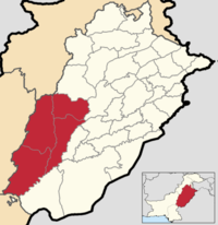 | ||
| Faisalabad Division | 14,185,231 | 17,918 km2 (6,918 sq mi) | 791.67/km2 (2,050.4/sq mi) | 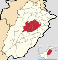 | ||
| Gujranwala Division | 16,120,861 | 17,207 km2 (6,644 sq mi) | 936.88/km2 (2,426.5/sq mi) |  | ||
| Gujrat Division | 5,507,282 | 9,438 km2 (3,644 sq mi) | 671.50/km2 (1,739.2/sq mi) |  | ||
| Lahore Division | 19,389,856 | 11,727 km2 (4,528 sq mi) | 1,653.44/km2 (4,282.4/sq mi) |  | ||
| Mianwali Division | 4,357,984 | Newly Established | Newly Established | Newly Established |  | |
| Multan Division | 14,085,102 | 12,268,173 | 15,211 km2 (5,873 sq mi) | 806.53/km2 (2,088.9/sq mi) |  | |
| Rawalpindi Division | 10,804,250 | 10,006,624 | 22,254 km2 (8,592 sq mi) | 449.66/km2 (1,164.6/sq mi) | 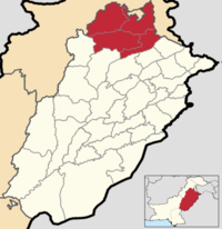 | |
| Sahiwal Division | 7,533,471 | 7,378,065 | 10,302 km2 (3,978 sq mi) | 716.18/km2 (1,854.9/sq mi) | 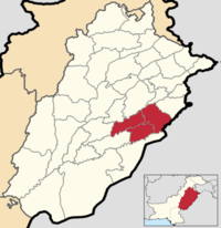 | |
| Sargodha Division | 5,835,537 | 8,167,037 | 26,360 km2 (10,180 sq mi) | 309.83/km2 (802.5/sq mi) |  |
List of Districts
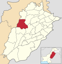
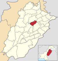
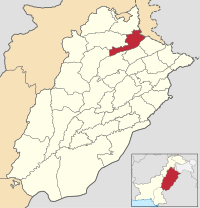
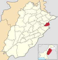
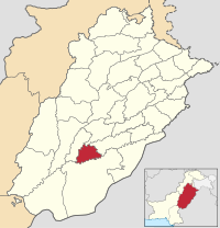
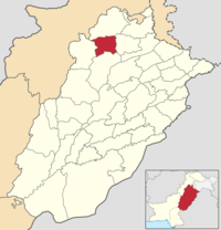
Below you will find a list of all 42 districts in the province of Punjab, along with the division it belongs to, the area of the district, the population and population density of the district, the average annual population growth rate of each district (between 1998 and 2017), and a map showing its location. The districts are initially listed in alphabetical order, but they can be sorted in different ways by clicking the headers of the table.
| Name | Division[18] | Population (2017)[18] | Total Area[27] | Population Density (2017) | Average Annual Population Growth Rate (1998 - 2017)[18] |
Map |
|---|---|---|---|---|---|---|
| Attock District | Rawalpindi | 1,886,378 | 6,857 km2 (2,648 sq mi) | 275.10/km2 (712.5/sq mi) | 2.08% |
 |
| Bahawalnagar District | Bahawalpur Division | 2,975,656 | 8,878 km2 (3,428 sq mi) | 335.17/km2 (868.1/sq mi) | 1.95% |
 |
| Bahawalpur District | Bahawalpur | 3,669,176 | 24,830 km2 (9,590 sq mi) | 147.77/km2 (382.7/sq mi) | 2.18% |
 |
| Bhakkar District | Mianwali | 1,647,852 | 8,153 km2 (3,148 sq mi) | 202.12/km2 (523.5/sq mi) | 2.39% |
 |
| Chakwal District | Rawalpindi | 1,495,463 | 6,525 km2 (2,519 sq mi) | 229.19/km2 (593.6/sq mi) | 1.71% |
 |
| Chiniot District | Faisalabad | 1,368,659 | 2,643 km2 (1,020 sq mi) | 517.84/km2 (1,341.2/sq mi) | 1.85% |
 |
| Dera Ghazi Khan District | Dera Ghazi Khan | 2,872,631 | 11,922 km2 (4,603 sq mi) | 240.95/km2 (624.1/sq mi) | 2.98% |
 |
| Faisalabad District | Faisalabad | 7,882,444 | 5,857 km2 (2,261 sq mi) | 1,345.82/km2 (3,485.7/sq mi) | 1.98% |
 |
| Gujranwala District | Gujranwala | 5,011,066 | 3,622 km2 (1,398 sq mi) | 1,383.51/km2 (3,583.3/sq mi) | 2.06% |
 |
| Gujrat District | Gujrat | 2,756,289 | 3,192 km2 (1,232 sq mi) | 863.50/km2 (2,236.5/sq mi) | 1.57% |
 |
| Hafizabad District | Gujrat | 1,156,954 | 2,367 km2 (914 sq mi) | 488.78/km2 (1,265.9/sq mi) | 1.74% |
 |
| Jampur District | Dera Ghazi Khan | |||||
| Jhang District | Faisalabad | 2,742,633 | 6,166 km2 (2,381 sq mi) | 444.80/km2 (1,152.0/sq mi) | 2.03% |
 |
| Jhelum District | Rawalpindi | 1,222,403 | 3,587 km2 (1,385 sq mi) | 340.79/km2 (882.6/sq mi) | 1.41% |
 |
| Khanewal District | Multan | 2,920,233 | 4,349 km2 (1,679 sq mi) | 671.47/km2 (1,739.1/sq mi) | 1.83% |
 |
| Khushab District | Sargodha | 1,280,372 | 6,511 km2 (2,514 sq mi) | 196.65/km2 (509.3/sq mi) | 1.84% |
 |
| Kot Addu District | Dera Ghazi Khan | N/A | N/A | N/A | N/A |  |
| Lahore District | Lahore | 11,119,985 | 1,772 km2 (684 sq mi) | 6,275.39/km2 (16,253.2/sq mi) | 3.00% |
 |
| Layyah District | Dera Ghazi Khan | 1,823,995 | 6,289 km2 (2,428 sq mi) | 290.03/km2 (751.2/sq mi) | 2.59% |
 |
| Lodhran District | Multan | 1,699,693 | 2,778 km2 (1,073 sq mi) | 611.84/km2 (1,584.7/sq mi) | 1.97% |
 |
| Mandi Bahauddin District | Gujrat | 1,594,039 | 2,673 km2 (1,032 sq mi) | 596.35/km2 (1,544.5/sq mi) | 1.68% |
 |
| Mianwali District | Mianwali | 1,542,601 | 5,840 km2 (2,250 sq mi) | 264.14/km2 (684.1/sq mi) | 2.01% |
 |
| Murree District | Rawalpindi | 352,783 | N/A | N/A | N/A |  |
| Multan District | Multan | 4,746,166 | 3,720 km2 (1,440 sq mi) | 1,275.85/km2 (3,304.4/sq mi) | 2.23% |
 |
| Muzaffargarh District | Dera Ghazi Khan | 4,328,549 | 8,249 km2 (3,185 sq mi) | 524.74/km2 (1,359.1/sq mi) | 2.64% |
 |
| Nankana Sahib District | Lahore | 1,354,986 | 2,216 km2 (856 sq mi) | 611.46/km2 (1,583.7/sq mi) | 1.37% |
 |
| Narowal District | Gujranwala | 1,707,575 | 2,337 km2 (902 sq mi) | 730.67/km2 (1,892.4/sq mi) | 1.59% |
 |
| Okara District | Sahiwal | 3,040,826 | 4,377 km2 (1,690 sq mi) | 694.73/km2 (1,799.3/sq mi) | 1.64% |
 |
| Pakpattan District | Sahiwal | 1,824,228 | 2,724 km2 (1,052 sq mi) | 669.69/km2 (1,734.5/sq mi) | 1.85% |
 |
| Kasur District | Lahore | 3,454,881 | 3,995 km2 (1,542 sq mi) | 864.80/km2 (2,239.8/sq mi) | 2.03% |
 |
| Rahim Yar Khan District | Bahawalpur | 4,807,762 | 11,880 km2 (4,590 sq mi) | 404.69/km2 (1,048.1/sq mi) | 2.26% |
 |
| Rajanpur District | Dera Ghazi Khan | 1,996,039 | 12,318 km2 (4,756 sq mi) | 162.04/km2 (419.7/sq mi) | 3.16% |
 |
| Rawalpindi District | Rawalpindi | 5,402,380 | 5,285 km2 (2,041 sq mi) | 1,022.21/km2 (2,647.5/sq mi) | 2.52% |
 |
| Sahiwal District | Sahiwal | 2,513,011 | 3,201 km2 (1,236 sq mi) | 785.07/km2 (2,033.3/sq mi) | 1.64% |
 |
| Sargodha District | Sargodha | 3,696,212 | 5,856 km2 (2,261 sq mi) | 631.18/km2 (1,634.7/sq mi) | 1.73% |
 |
| Sheikhupura District | Lahore | 3,460,004 | 3,744 km2 (1,446 sq mi) | 924.15/km2 (2,393.5/sq mi) | 2.22% |
 |
| Sialkot District | Gujranwala | 3,894,938 | 3,016 km2 (1,164 sq mi) | 1,291.43/km2 (3,344.8/sq mi) | 1.90% |
 |
| Talagang District | Mianwali | 527,756 | 2,932 km2 (1,132 sq mi) | 1,132/km2 (2,930/sq mi) | 1.90% |
 |
| Taunsa District | Dera Ghazi Khan | N/A | N/A | N/A | N/A |  |
| Toba Tek Singh District | Faisalabad | 2,191,495 | 3,252 km2 (1,256 sq mi) | 673.89/km2 (1,745.4/sq mi) | 1.59% |
 |
| Vehari District | Multan | 2,902,081 | 4,364 km2 (1,685 sq mi) | 665.00/km2 (1,722.3/sq mi) | 1.74% |
 |
| Wazirabad District | Gujrat | 830,396 | 1,206 km2 (466 sq mi) | 690.00/km2 (1,787.1/sq mi) | N/A |  |
See also
Pakistan articles | |||||||||||||||||||
|---|---|---|---|---|---|---|---|---|---|---|---|---|---|---|---|---|---|---|---|
| |||||||||||||||||||
| |||||||||||||||||||
| |||||||||||||||||||
| |||||||||||||||||||
| |||||||||||||||||||
| History |  | |
|---|---|---|
| Government | ||
| Culture | ||
| Geography | ||
| Divisions |
| |
| Districts |
| |
| Education | ||
| Sport | ||
| Major cities | ||
Provincial capital: Lahore | ||
| Bahawalpur |  | |
| Dera Ghazi Khan | ||
| Faisalabad | ||
| Gujranwala | ||
| Gujrat | ||
| Lahore | ||
| Mianwali | ||
| Multan | ||
| Rawalpindi | ||
| Sahiwal | ||
| Sargodha | ||
References
- ^ "Administrative and regional divisions of Hokkaidō, Honshū, Shikoku, and Kyūshū". dx.doi.org. Retrieved 31 March 2024.
- ^ The Annals of Indian Administration. 1870.
- ^ "Report on the census of the Punjab taken on 10th January, 1868". Report on the census of the Punjab take on 10 January 1868. on JSTOR. Indian Public Opinion Press. 1870. JSTOR saoa.crl.25057644. Archived from the original on 28 September 2020. Retrieved 28 September 2020.
- ^ Commission, Indian Historical Records (1985). Proceedings of the Meetings. Government of India Press. p. 392.
- ^ The Panjab Past and Present. Department of Punjab Historical Studies, Punjabi University. 1986. p. 152.
- ^ Office, Great Britain India (1878). A Catalogue of Manuscript and Printed Reports, Field Books, Memoirs, Maps, Etc., of the Indian Surveys: Deposited in the Map Room of the India Office. W.H. Allen & Company. p. 239.
- ^ Sir Edward MacLagan (1892). "The Punjab and its feudatories, part I--The report on the census". The Punjab and its feudatories, part 1--The report on the census on JSTOR. 1. Office of the Supt. of Govt. Print., India, 1892. JSTOR saoa.crl.25318668. Archived from the original on 28 September 2020. Retrieved 28 September 2020.
- ^ a b "Census of India 1901. Vol. 17, The Punjab, its feudatories and the North-west Frontier Province. Pt. 1, The report on the census". Census of India 1901. Vol. 17, The Punjab, its feudatories and the North-west Frontier Province. Pt. 1, The report on the census. on JSTOR. Simla: Government Central Printing Office. 1902. JSTOR saoa.crl.25363738. Archived from the original on 28 September 2020. Retrieved 28 September 2020.
- ^ "Census of India 1911. Vol. 14, Punjab. Pt. 1, Report". Census of India 1911. Vol. 14, Punjab. Pt. 1, Report. on JSTOR. Lahore: Government Central Printing Office. 1912. JSTOR saoa.crl.25393787. Archived from the original on 14 August 2020. Retrieved 28 September 2020.
- ^ "Census of India 1921. Vol. 15, Punjab and Delhi. Pt. 1, Report". Census of India 1921. Vol. 15, Punjab and Delhi. Pt. 1, Report. on JSTOR. Superintendents of Census Operations, Punjab in Lahore. 1923. JSTOR saoa.crl.25430164. Archived from the original on 29 September 2020. Retrieved 29 September 2020.
- ^ Khan, Ahmad Hasan (1931). "Census of India, 1931, vol. XVII. Punjab. Part I-". Census of India, 1931, vol. XVII. Punjab. Part I- on JSTOR. Lahore, Printed at the "Civil and military gazette" Press, 1933. JSTOR saoa.crl.25793222. Archived from the original on 7 June 2020. Retrieved 29 September 2020.
- ^ a b c d e f India Census Commissioner (1941). "Census of India, 1941. Vol. 6, Punjab". Census of India, 1941. Vol. 6, Punjab on JSTOR. 6. [Calcutta?] : [publisher not identified], 1941-45. JSTOR saoa.crl.28215541. Retrieved 29 September 2020.
- ^ a b c d e Tariq Amir (3 October 2014). "Partition Of Punjab in 1947". Pakistan Geotagging: Partition Of Punjab in 1947. Tariq Amir on Blogspot. Archived from the original on 27 March 2020. Retrieved 29 September 2020.
- ^ "CENSUS OF PAKISTAN, 1951 URBAN AND RURAL POPULATION & AREA (TABLES 1 & 1A)" (PDF). Census of Pakistan 1951 Urban & Rural Population & Area.pdf. OFFICE OF THE CENSUS COMMISSIONER GOVERNMENT OF PAKISTAN, MINISTRY OF THE INTERIOR KARACHI . September 1952. Archived from the original (PDF) on 26 August 2020. Retrieved 29 September 2020.
- ^ "Census of Pakistan Population 1961 Volume 1" (PDF). 1961 Population Census of Pakistan.pdf. The Ministry of Home & Kashmir Affairs (Home Affairs Division) Government of Pakistan. 1964. Archived from the original (PDF) on 26 August 2020. Retrieved 29 September 2020.
- ^ a b c d e f g h i j "1981 CENSUS REPORT OF PAKISTAN" (PDF). Population Census of Pakistan 1981 PAKISTAN.pdf. POPULATION CENSUS ORGANIZATION STATISTICS DIVISION GOVERNMENT OF PAKISTAN. December 1984. Archived (PDF) from the original on 26 August 2020. Retrieved 29 September 2020.
- ^ a b c d e f g h i j k l m n o p q r s "1951 - 1998 POPULATION OF ADMINISTRATIVE UNITS (AS ON 1st MARCH 1998)" (PDF). 1951-98 Population of Administrative Units (As on 1st March, 1998).pdf. POPULATION CENSUS ORGANIZATION STATISTICS DIVISION GOVERNMENT OF PAKISTAN. January 2002. Archived (PDF) from the original on 23 August 2020. Retrieved 16 October 2020.
- ^ a b c d e f g h i j "TABLE - 3 AREA, POPULATION BY SEX, SEX RATIO, POPULATION DENSITY, URBAN PROPORTION, HOUSEHOLD SIZE AND ANNUAL GROWTH RATE OF PUNJAB" (PDF). punjab_tehsil.pdf. Pakistan Bureau of Statistics. 19 May 2021. Archived (PDF) from the original on 20 May 2021. Retrieved 21 May 2021.
- ^ "Nankana Sahib officially made district". Nankana Sahib officially made district - Newspaper - DAWN.COM. Dawn. 2 July 2005. Archived from the original on 17 August 2020. Retrieved 17 August 2020.
- ^ "Nankana Sahib". Nankana Sahib | Punjab Portal. Government of the Punjab. Archived from the original on 17 August 2020. Retrieved 17 August 2020.
- ^ "Chiniot gets district status: Rs500m for infrastructure". Chiniot gets district status: Rs500m for infrastructure - Newspaper - DAWN.COM. Dawn. 3 February 2009. Archived from the original on 17 August 2020. Retrieved 17 August 2020.
- ^ "Dawn News". Retrieved 29 September 2022.
- ^ "Punjab CM approves establishment of four new districts in province". Daily Times. 15 October 2022. Retrieved 15 October 2022.
- ^ "CM approves five new districts in Punjab". The Express Tribune. 14 October 2022. Retrieved 15 October 2022.
- ^ Reporter, News (14 January 2023). "ECP bars Punjab gov from notifying Mianwali as division". Duniya News. p. 1. Retrieved 14 January 2023.
- ^ "NA strength reduced to 336 in new delimitation". The Express Tribune. 27 September 2023. Retrieved 20 October 2023.
- ^ a b "TABLE-1: AREA & POPULATION OF ADMINISTRATIVE UNITS BY RURAL/URBAN: 1951-1998 CENSUSES" (PDF). Administrative Units.pdf. Pakistan Bureau of Statistics. Archived (PDF) from the original on 20 June 2020. Retrieved 8 September 2020.