To install click the Add extension button. That's it.

The source code for the WIKI 2 extension is being checked by specialists of the Mozilla Foundation, Google, and Apple. You could also do it yourself at any point in time.

4,5
Kelly Slayton
Congratulations on this excellent venture… what a great idea!
Alexander Grigorievskiy
I use WIKI 2 every day and almost forgot how the original Wikipedia looks like.
Live Statistics
English Articles
Improved in 24 Hours
Added in 24 Hours
Languages
Recent
Show all languages
What we do. Every page goes through several hundred of perfecting techniques; in live mode. Quite the same Wikipedia. Just better.
.
Leo
Newton
Brights
Milds

List of airports in the Turks and Caicos Islands

From Wikipedia, the free encyclopedia

Map of Turks and Caicos Islands

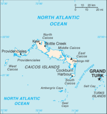
This is a list of airports in the Turks and Caicos Islands, sorted by location. The Turks and Caicos Islands are a British Overseas Territory located southeast of Mayaguana in the Bahamas and north of the island of Hispaniola. It consists of two groups of sub-tropical islands in the West Indies, the larger Caicos Islands and the smaller Turks Islands. The total population is about 36,000, of whom approximately 22,500 live on Providenciales in the Caicos Islands. Cockburn Town, the capital, is on Grand Turk Island.

YouTube Encyclopedic

  • 1/2
    Views:
    372
    632
  • The Spirit of the Turks&Caicos Islands / Wonderful Vacation!
  • Top 10 Most Beautiful Beaches in the world | Top 10 best beaches in the world 2016-2017

Transcription

Airports

Names shown in bold indicate the airport has scheduled passenger service on commercial airlines.

Island ICAO IATA Airport name Coordinates
Ambergris Cay (Caicos Islands) MBAC Harold Charles International Airport 21°18′2″N 71°38′28″W / 21.30056°N 71.64111°W / 21.30056; -71.64111 (Harold Charles International Airport)
Grand Turk Island (Turks Islands) MBGT GDT JAGS McCartney International Airport 21°26′40″N 071°08′32″W / 21.44444°N 71.14222°W / 21.44444; -71.14222 (JAGS McCartney International Airport)
Middle Caicos (Caicos Islands) MBMC MDS Middle Caicos Airport 21°49′33″N 071°48′09″W / 21.82583°N 71.80250°W / 21.82583; -71.80250 (Middle Caicos Airport)
North Caicos (Caicos Islands) MBNC NCA North Caicos Airport 21°55′03″N 071°56′22″W / 21.91750°N 71.93944°W / 21.91750; -71.93944 (North Caicos Airport)
Pine Cay (Caicos Islands) MBPI PIC Pine Cay Airport 21°52′29.88″N 72°5′32.69″W / 21.8749667°N 72.0924139°W / 21.8749667; -72.0924139 (Pine Cay Airport)
Providenciales (Caicos Islands) MBPV PLS Providenciales International Airport 21°46′25″N 72°15′57″W / 21.77361°N 72.26583°W / 21.77361; -72.26583 (Providenciales International Airport)
Salt Cay (Turks Islands) MBSY SLX Salt Cay Airport 21°20′N 071°12′W / 21.333°N 71.200°W / 21.333; -71.200 (Salt Cay Airport)
South Caicos (Caicos Islands) MBSC XSC South Caicos Airport 21°30′57″N 071°31′43″W / 21.51583°N 71.52861°W / 21.51583; -71.52861 (South Caicos Airport)
West Caicos (Caicos Islands) MB01 West Caicos Aerodrome 21°39′9″N 072°27′57.6″W / 21.65250°N 72.466000°W / 21.65250; -72.466000 (West Caicos Airport)

See also

References

  • Turks and Caicos Islands Government: Civil Aviation
  • Turks and Caicos Tourist Board: Travel Information
  • "ICAO Location Indicators by State" (PDF). International Civil Aviation Organization. 12 January 2006.
  • "UN Location Codes: Turks and Caicos Islands". UN/LOCODE 2009-2. UNECE. 8 February 2010. - includes IATA codes
  • Great Circle Mapper: Turks and Caicos Islands - IATA and ICAO codes


This page was last edited on 22 November 2022, at 03:34
Basis of this page is in Wikipedia. Text is available under the CC BY-SA 3.0 Unported License. Non-text media are available under their specified licenses. Wikipedia® is a registered trademark of the Wikimedia Foundation, Inc. WIKI 2 is an independent company and has no affiliation with Wikimedia Foundation.