
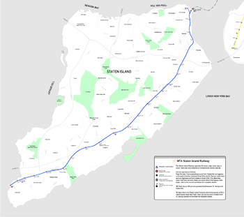
The Staten Island Railway (formerly known as the Staten Island Rapid Transit) is a rapid transit system on Staten Island, New York. Its operator has been the Metropolitan Transportation Authority of New York since 1971, whereas prior to that year it was owned by the Baltimore & Ohio Railroad (B&O).
YouTube Encyclopedic
-
1/1Views:739 432
-
The Station Nightclub Fire
Transcription
Main Line
This list contains all stations currently operating on the Staten Island Railway (SIR). All active SIR stations are located on the Main Line, which spans from the St. George Ferry Terminal to Tottenville. Stations tend to be built either above ground level on embankments or are open-cut stations built below ground level, but open to the sky.
| Station is accessible by wheelchair[1] |
| Name | Opened | Other names | Connections/Notes | |
|---|---|---|---|---|
| St. George | March 7, 1886 | Staten Island Ferry | ||
| Tompkinsville | July 31, 1884 | |||
| Stapleton | July 31, 1884 1936 |
|||
| Clifton | April 23, 1860 | Vanderbilt's Landing | Only three cars can platform at the St. George-bound platform. This station was the original northern terminal of the line. | |
| Grasmere | c. 1886 | S53 bus to Bay Ridge, Brooklyn | ||
| Old Town | 1937–1938 | Old Town Road | ||
| Dongan Hills | April 23, 1860 | Garretson's | ||
| Jefferson Avenue | 1937–1938 | |||
| Grant City | April 23, 1860 | |||
| New Dorp | April 23, 1860 | |||
| Oakwood Heights | April 23, 1860 | Richmond, then Court House, then Oakwood | ||
| Bay Terrace | Early 1900s | Brendan, then Whitlock | ||
| Great Kills | April 23, 1860 | Gifford's | ||
| Eltingville | April 23, 1860 | Bus to Eltingville Transit Center and Staten Island Mall | ||
| Annadale | May 14, 1860 1939 |
|||
| Huguenot | June 2, 1860 | Bloomingview, then Huguenot Park | ||
| Prince's Bay | June 2, 1860 | Lemon Creek Princes Bay |
||
| Pleasant Plains | June 2, 1860 | |||
| Richmond Valley | June 2, 1860 | Only three cars can platform at this station. The former West Shore Line, which was used for freight, diverged south of this station. | ||
| Arthur Kill | January 21, 2017 | |||
| Tottenville | June 2, 1860 | Formerly connected to a ferry to Perth Amboy, New Jersey |
Disused and former stations
The majority of former stations are located on the North Shore Branch and South Beach Branch, which were closed to passenger service at midnight on Tuesday, March 31, 1953. A small western portion of the North Shore Branch that is disconnected to the Main Line is used for freight service, and a smaller eastern portion of the same branch provided seasonal service to the Richmond County Bank Ballpark station from 2001 to 2009. Restoration is being discussed along this mostly abandoned 6.1-mile (9.8 km) line as part of the Staten Island light rail plan.[2] The South Beach Branch was abandoned and demolished except for a remaining stanchion on St. John's Avenue and the Robin Road Trestle.[3][4] This 4.1-mile (6.6 km) line diverged from the Main Line south of the Clifton station and lay to the east of the Main Line.
| Name | Line | Opened | Closed | Distance from St. George | Notes |
|---|---|---|---|---|---|
| Arlington | North Shore Branch | 1889–1890 | March 31, 1953 | 5.2 miles (8.4 km) | |
| Arrochar | South Beach Branch | March 8, 1886 | March 31, 1953 | 3.2 miles (5.1 km) | |
| Atlantic | Main Line | 1909-1911 | January 21, 2017 | 26.1 miles (42.0 km) | |
| Bachmann | South Beach Branch | March 8, 1886 | 1937 | 2.0 miles (3.2 km) | |
| Belair Road | South Beach Branch | March 8, 1886 | March 31, 1953 | 2.5 miles (4.0 km) | |
| Cedar Avenue | South Beach Branch | 1931[5] | March 31, 1953 | 3.5 miles (5.6 km) | |
| Elm Park | North Shore Branch | February 23, 1886 | March 31, 1953 | 3.9 miles (6.3 km) | |
| Fort Wadsworth | South Beach Branch | March 8, 1886 | March 31, 1953 | 2.7 miles (4.3 km) | |
| Harbor Road | North Shore Branch | 1935–1937 | March 31, 1953 | 4.9 miles (7.9 km) | |
| Lake Avenue | North Shore Branch | 1937 | March 31, 1953 | 4.3 miles (6.9 km) | |
| Livingston | North Shore Branch | February 23, 1886 | March 31, 1953 | 1.8 miles (2.9 km) | |
| Mariners Harbor | North Shore Branch | Summer 1886 | March 31, 1953 | 4.6 miles (7.4 km) | |
| Mount Loretto Orphanage | Mount Loretto Branch[6][7] | 1885 | 1950 | This station was used for special excursions. | |
| Nassau | Main Line | after 1922 | January 21, 2017 | 25.7 miles (41.4 km) | Served the Nassau Smelting Company. |
| New Brighton | North Shore Branch | February 26, 1886 | March 31, 1953 | 0.7 miles (1.1 km) | |
| Ocean Park | Main Line | Flag stop, south of Annadale, c.1890. | |||
| Port Ivory | North Shore Branch | 1906 | 1948 | 6.1 miles (9.8 km) | Served the employees of Procter & Gamble's factory. |
| Port Richmond | North Shore Branch | February 26, 1886 | March 31, 1953 | 3.0 miles (4.8 km) | |
| Richmond County Bank Ballpark | North Shore Branch | June 24, 2001 | June 18, 2010 | 150 yards (140 m) | |
| Rosebank | South Beach Branch | March 8, 1886 | March 31, 1953 | 2.1 miles (3.4 km) | |
| Sailors' Snug Harbor | North Shore Branch | February 26, 1886 | March 31, 1953 | 1.2 miles (1.9 km) | |
| South Beach | South Beach Branch | 1890 | March 31, 1953 | 3.9 miles (6.3 km) | |
| Tower Hill | North Shore Branch | February 26, 1886 | March 31, 1953 | 3.4 miles (5.5 km) | |
| Wentworth Avenue | South Beach Branch | 1925 | March 31, 1953 | 4.1 miles (6.6 km) | This likely was the shortest rapid transit station in the world. |
| West Brighton | North Shore Branch | February 26, 1886 | March 31, 1953 | 2.4 miles (3.9 km) | |
| Woods of Arden | Main Line | 1886 | 1894–1895 | 14.6 miles (23.5 km) |
See also
- New York City Subway stations
- List of New York City Subway stations
- List of New York City Subway transfer stations
- List of New York City Subway terminals
- List of closed New York City Subway stations
- Accessibility of the Metropolitan Transportation Authority
References
- ^ "MTA Guide to Accessible Transit: Accessible Stations in the MTA Network". New York Metropolitan Transportation Authority. Retrieved November 21, 2012.
- ^ Yates, Maura; Helsel, Phil (July 12, 2008). "Reality check for Staten Island's rail plans". Retrieved February 24, 2009.
- ^ "Gary Owen's S.I.R.T. South Beach Line Page". Retrieved March 7, 2009.
- ^ "Gary Owen's S.I.R.T. South Beach Line Page". p. 2. Retrieved March 7, 2009.
- ^ Eleventh Annual Report For The Calendar Year 1931. New York State Transit Commission. 1922. p. 75.
- ^ "Gary Owen's SIRT Page". gretschviking.net.
- ^ Staten Island Rapid Transit: The Essential History, by Irvin Leigh & Paul Matus (The Third Rail Online) Archived August 26, 2014, at the Wayback Machine
External links
- SIRT Track Map on nycsubway.org
| Current services |
| ||||||||||||
|---|---|---|---|---|---|---|---|---|---|---|---|---|---|
| Defunct services |
| ||||||||||||
| Stations (List) |
| ||||||||||||
| Divisions | |||||||||||||
| Other lists | |||||||||||||
| History |
| ||||||||||||
| Infrastructure | |||||||||||||
| Arts and culture | |||||||||||||
| Miscellaneous | |||||||||||||
| Other rapid transit in NYC |
| ||||||||||||