
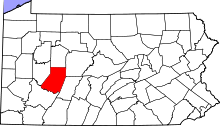
This is a list of the Pennsylvania state historical markers in Indiana County.
This is intended to be a complete list of the official state historical markers placed in Indiana County, Pennsylvania by the Pennsylvania Historical and Museum Commission (PHMC). The locations of the historical markers, as well as the latitude and longitude coordinates as provided by the PHMC's database, are included below when available. There are 16 historical markers located in Indiana County.[1]
YouTube Encyclopedic
-
1/5Views:3746513941 4253 388
-
Illinois Adventure #1403 "Illinois Oil Field Museum"
-
Researcher Talk: Sex on the Frontier
-
Illustrating Thoreau's Maine Woods: A Photographer's Journey
-
Lewis Powell (conspirator)
-
Interstate Highway System
Transcription
Historical markers
| Marker title | Image | Date dedicated | Location | Marker type | Topics |
|---|---|---|---|---|---|
| Jim Nance | November 3, 2018 | Philadelphia Street, Indiana 40°34′41″N 79°07′59″W / 40.577917°N 79.133133°W |
Roadside | African American, Football Player | |
| Absalom (Albert) Hazlett (1837-1860) | March 27, 2009 | South 6th Street extension (PA 954) (near PA Barbeque), Indiana 40°34′41″N 79°07′59″W / 40.577917°N 79.133133°W |
Roadside | African American, Civil War, Military | |
| Dr. Robert Mitchell (1786-1863) | October 17, 2007 | Franklin Street (PA 286) near 2nd Street (PA 403), Clymer 40°40′22″N 79°00′24″W / 40.672750°N 79.006633°W |
Roadside | African American, Underground Railroad | |
| Edward Abbey | September 28, 1996 | Buffalo-Pittsburgh Highway (US 119) at N end of Home 40°44′05″N 79°06′16″W / 40.73465°N 79.10432°W |
Roadside | Environment, Writers | |
| Fugitive Slave Rescue | April 17, 2004 | West Market Street at Liberty Street, Blairsville (MISSING) |
City | African American, Government & Politics 19th Century, Underground Railroad | |
| Indiana County | September 10, 1982 | New Courthouse Square, 8th & Philadelphia Streets, Indiana 40°37′23″N 79°09′19″W / 40.62307°N 79.15523°W |
City | Government & Politics, Government & Politics 19th Century | |
| James Maitland Stewart (1908-1997) | 
|
July 2, 1998 | Jimmy Stewart Museum, 9th & Philadelphia Streets, Indiana 40°37′23″N 79°09′22″W / 40.62312°N 79.156°W |
Roadside | Military, Military Post-Civil War, Motion Pictures & Television, Performers |
| John B. McCormick | September 15, 1951 | US 22 just west of Armagh (MISSING-POST EXISTS) 40°27′15″N 79°02′21″W / 40.454255°N 79.039186°W |
Roadside | Business & Industry, Entrepreneurs, Invention | |
| John S. Fisher | 
|
September 14, 1950 | Junction PA 85 & 210 E of Plumville 40°47′40″N 79°09′59″W / 40.7944°N 79.16645°W --> |
Roadside | Government & Politics, Government & Politics 20th Century, Governors |
| Linton Park (1826-1906) | September 27, 2008 | At Linton Park, North Manor Street, Marion Center 40°46′16″N 79°02′59″W / 40.771169°N 79.049785°W |
Roadside | Agriculture, Artists, Labor | |
| Moorhead's Fort | July 9, 1951 | Philadelphia Street & Heritage Run Road, .6 mile W of Indiana |
Roadside | American Revolution, French & Indian War, Military, Native American | |
| Purchase of 1768 | July 2, 1948 | US 219 at Cherry Tree (MISSING) |
Roadside | Government & Politics, Native American | |
| Rescue of Anthony Hollingsworth, The | September 27, 2002 | Philadelphia Street (PA 286) & North 6th Street, Indiana 40°37′23″N 79°09′04″W / 40.623083°N 79.151067°W |
City | African American, Underground Railroad | |
| Rossiter Strike Injunction | September 6, 2004 | Shaffer Field, Central Street at West Side Street, Rossiter 40°53′46″N 78°56′08″W / 40.896200°N 78.935633°W |
Roadside | Coal, Government & Politics 20th Century, Labor | |
| Rural Electrification | 1988 | Airport Road, just off PA 286 at E end of Indiana 0°37′58″N 79°07′07″W / .632850°N 79.118683°W |
Roadside | Business & Industry, Electricity | |
| Saltsburg | 
|
February 4, 1984 | Washington Street (PA 286) at Canal Street, Saltsburg 40°29′10″N 79°27′07″W / 40.48618°N 79.45203°W |
City | Business & Industry, Cities & Towns |
| William H. Sylvis | September 1, 1990 | Keith Hall, Indiana University of Pennsylvania, Indiana 40°37′06″N 79°09′23″W / 40.618250°N 79.156417°W |
City | Labor |
See also
- List of Pennsylvania state historical markers
- National Register of Historic Places listings in Indiana County, Pennsylvania
References
- ^ "PHMC Historical Markers Search" (Searchable database). Pennsylvania Historical and Museum Commission. Commonwealth of Pennsylvania. Retrieved 2010-07-19.
External links
Municipalities and communities of Indiana County, Pennsylvania, United States | ||
|---|---|---|
| Boroughs |  | |
| Townships | ||
| CDPs | ||
| Other communities | ||
