
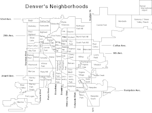
The City and County of Denver, capital of the U.S. state of Colorado, has 78 official neighborhoods as of January 2013.[1] In addition to the official administrative neighborhoods, many residents have names for local neighborhoods that may not conform to the boundaries of official neighborhoods. Denver does not have any official larger area designations, unlike the City of Chicago for example, which has larger areas that house the neighborhoods (IE: Northwest Side). Denver residents use the terms "north" "south" "east" and "west" loosely, and the neighborhoods as categorized below reflect this.[2]
YouTube Encyclopedic
-
1/3Views:60069 829423 602
-
Top 3 Best Denver Neighborhoods | Are You Considering Living In Denver? | Moving To Denver
-
History Of Tha Streetz: Denver, CO
-
Top 10 Reasons NOT to Move to Denver, Colorado
Transcription
Central

- Baker
- Capitol Hill
- Central Business District
- Cheesman Park
- Cherry Creek
- City Park
- City Park West
- Civic Center
- Congress Park
- Country Club
- Lincoln Park
- North Capitol Hill
- Speer
- Union Station
East

- Belcaro
- Cory-Merrill
- East Colfax
- Hale
- Hilltop
- Indian Creek
- Lowry
- Montclair
- Park Hill
- Virginia Village
- Washington Virginia Vale
- Windsor
North

- Clayton
- Cole
- Elyria-Swansea
- Five Points
- Globeville
- North Park Hill
- Skyland
- South Park Hill
- Whittier
Northeast

- Central Park
- Denver International Airport
- Gateway/Green Valley Ranch
- Montbello
- Northeast Park Hill
Northwest

South

- College View/South Platte
- Overland
- Platt Park
- Rosedale
- University
- University Hills
- University Park
- Washington Park
- Washington Park West
- Wellshire
Southeast
- Goldsmith
- Hampden
- Hampden South
- Kennedy
- Southmoor Park
Southwest
- Bear Valley
- Fort Logan
- Harvey Park
- Harvey Park South
- Marston
West
- Athmar Park
- Barnum
- Barnum West
- Mar Lee
- Ruby Hill
- Sun Valley
- Valverde
- Villa Park
- West Colfax
- Westwood
Non-official Neighborhoods

- Alamo Placita – A historic district, part of the larger Speer neighborhood.
- Ballpark District – An active area that includes Coors Field and several blocks east, part of the Five Points neighborhood.
- Burns Brentwood
- Crestmoor
- Curtis Park
- Golden Triangle – An area which incorporates many of Denver's civic and cultural institutions, roughly corresponds with the Civic Center neighborhood.
- Hampden Heights
- LoDo – Original settlement of Denver, with many of its oldest buildings and is known for its nightlife, overlaps parts of the Union Station and Five Points neighborhoods.
- Mayfair
- Parkfield
- RiNo
- Northside
- South Denver
- Uptown – Roughly corresponds with North Capitol Hill neighborhood.
See also
- Bibliography of Colorado
- Geography of Colorado
- History of Colorado
- Index of Colorado-related articles
- List of Colorado-related lists
- Outline of Colorado
References
- ^ "Denver Statistical Neighborhood Boundaries map" (PDF). DenverGov. Archived from the original (PDF) on 2015-02-18. Retrieved Oct 15, 2013.
- ^ "Find A City To Love - Where to Live in Denver". MetroSeeker.com. Archived from the original on 2013-08-29. Retrieved 2013-09-15.
External links
Denver at Wikipedia's sister projects
 Media from Commons
 News from Wikinews
 Quotations from Wikiquote
 Travel information from Wikivoyage
- The City and County of Denver
- List of Denver neighborhoods with descriptions, maps, homes – useful information for newcomers

39°44′21″N 104°59′06″W / 39.7392°N 104.9850°W