To install click the Add extension button. That's it.

The source code for the WIKI 2 extension is being checked by specialists of the Mozilla Foundation, Google, and Apple. You could also do it yourself at any point in time.

4,5
Kelly Slayton
Congratulations on this excellent venture… what a great idea!
Alexander Grigorievskiy
I use WIKI 2 every day and almost forgot how the original Wikipedia looks like.
Live Statistics
English Articles
Improved in 24 Hours
Added in 24 Hours
Languages
Recent
Show all languages
What we do. Every page goes through several hundred of perfecting techniques; in live mode. Quite the same Wikipedia. Just better.
.
Leo
Newton
Brights
Milds

Linha da Beira Alta

From Wikipedia, the free encyclopedia

Linha da Beira Alta
Linha da Beira Alta close to Pampilhosa.
Overview
StatusOperational
OwnerInfraestruturas de Portugal
Termini
  • Pampilhosa
  • Vilar Formoso
Technical
Line length202 km (126 mi)[1]
Track gaugeIberian
Electrification25 kV / 50 kHz Overhead line
Route map
Linha da Beira Alta
km
50.426
Pampilhosa
73.549
Mortágua
85.474
Santa Comba Dão
97.960
Carregal do Sal
102.368
Oliveirinha-Cabanas
109-097
Canas-Felgueira
117.212
Nelas
128.509
Mangualde
133.799
Contenças
144.208
Gouveia
152.243
Fornos de Algodres
167.919
Celorico da Beira
181.834
Vila Franca das Naves
206.307
Guarda
225.872
Cerdeira
251.894
Vilar Formoso
Detailed diagram
km
50.426
Pampilhosa
54.052
Quinta do Valongo-Vacariça
56.320
Pego
Carpinteiros tunnel
58 m
59.220
Luso-Buçaco
Pequeno Salgueiral tunnel
103 m
Grande Salgueiral tunnel
1,096 m
Portinhas tunnel
76 m
Várzeas River
63.200
Trezói
Trezói tunnel
542 m
Azeval tunnel
200 m
67.407
Soito
Espinho tunnel
190 m
Ribeira tunnel
84 m
Monte Lobos tunnel
390 m
70.800
Monte dos Lobos/
Monte de Lobos
73.549
Mortágua
76.000
Freixo
Breda
Coval tunnel
33 m
Linha de Penacova
to Coimbra
(
cancelled
extension
)
85.474
Santa Comba Dão
89.830
Castelejo
93.629
Papízios
95.600
Póvoa da Arenosa
97.960
Carregal do Sal
99.700
Alvarelhos
102.368
Oliveirinha-Cabanas
103.901
Fiais da Telha
107.050
Lapa do Lobo
109.097
Canas-Felgueira
111.900
Urgeiriça
115.453
Folhadal
117.212
Nelas
Vilar Seco
123.870
Moimenta-Alcafache
128.509
Mangualde
Murilo tunnel
228 m
133.799
Contenças
139.888
Abrunhosa
140.260
Abrunhosa
(original)
Abrunhosa tunnel
305 m
144.208
Gouveia
152.243
Fornos de Algodres
157.617
Muxagata
160.655
Vila Boa do Mondego
167.919
Celorico da Beira
170.980
Minhocal
173.154
Baraçal
176.008
Maçal do Chão
177.890
Maçal da Ribeira
181.834
Vila Franca das Naves
Linha do Côa
to Pocinho
(
cancelled
branch
)
184.682
Cerejo
187.268
Pinhel
191.670
Trajinha / Trajadinha
199.572
Sobral
originally
Sobral-Avelãs
202.500
Alvendre
206.307
Guarda
Linha da Beira Baixa
to Entroncamento
210.395
Gata
Ramal de Monte Barro
to Sabugal
(
cancelled
branch
)
213.516
Vila Garcia
216.894
Vila Fernando
222.008
Rochoso
225.872
Cerdeira
229.085
Miuzela
232.712
Noémi
237.275
Castelo Mendo
239.606
Malhada Sorda
244.241
Freineda
246.883
Aldeia
originally Aldeia
de São Sebastião
 
251.894
Vilar Formoso
252.161

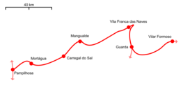
Linha da Beira Alta is an international railway line which connects Pampilhosa on the Linha do Norte, close to Coimbra, to the border with Spain, at Vilar Formoso.

The electrified, mostly single-track, iberian gauge (1,668 m) line runs parallel to the Mondego River.[2] It is the main railway access from Portugal to the rest of Europe.[1] It was constructed by Companhia dos Caminhos de Ferro Portugueses da Beira Alta to open a new international link, closer to Coimbra, and to connect the line to the Port of Figueira da Foz. It was opened on 3 August 1882.[3] During the modernisation and electrification in the 1980s and 90s the signalling and tracks were replaced.[1]

As of June 2023, the entire line is closed for further modernisation work with buses replacing passenger trains. Completion date unknown. The works include construction of a new chord, the Concordância da Mealhada, allowing freight trains from the north to avoid the Pampilhosa area. Level (grade) crossings are to be eliminated and upgraded signalling installed. More information, in Portuguese, at https://www.infraestruturasdeportugal.pt/pt-pt/modernizacao-da-linha-da-beira-alta-2

Linha da Beira Alta diagram on azulejos artwork at the Vilar Formoso railway station

See also

References

  1. ^ a b c Martins et al, 1996:198-199
  2. ^ "Beira alta, Beira baja y los Ramales de Cáceres y Badajoz". Maquetren (in Spanish). Madrid: A. G. B., s. l. 1994.
  3. ^ Torres, Carlos Manitto (1 February 1958). "A evolução das linhas portuguesas e o seu significado ferroviário" (PDF). Gazeta dos Caminhos de Ferro. Retrieved 11 January 2019.

Sources

  • Martins, João; Brion, Madalena; Sousa, Miguel (1996). O Caminho de Ferro Revisitado (in Portuguese). Lisbon: Caminhos de Ferro Portugueses.
  • "2019 Network Statement" (PDF). 7 December 2018. Retrieved 20 January 2019. {{cite journal}}: Cite journal requires |journal= (help)


This page was last edited on 23 January 2024, at 16:43
Basis of this page is in Wikipedia. Text is available under the CC BY-SA 3.0 Unported License. Non-text media are available under their specified licenses. Wikipedia® is a registered trademark of the Wikimedia Foundation, Inc. WIKI 2 is an independent company and has no affiliation with Wikimedia Foundation.