
Lingewaal | |
|---|---|
 Former windmill in Herwijnen | |
 Flag  Coat of arms | |
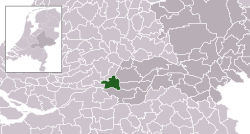 Location in Gelderland | |
| Coordinates: 51°53′N 5°7′E / 51.883°N 5.117°E | |
| Country | Netherlands |
| Province | Gelderland |
| Municipality | West Betuwe |
| Established | 1 January 1986 |
| Merged | 2019 |
| Area | |
| • Total | 54.49 km2 (21.04 sq mi) |
| • Land | 50.44 km2 (19.47 sq mi) |
| • Water | 4.05 km2 (1.56 sq mi) |
| Elevation | 2 m (7 ft) |
| Population (January 2021)[3] | |
| • Total | data missing |
| Time zone | UTC+1 (CET) |
| • Summer (DST) | UTC+2 (CEST) |
| Postcode | Parts of 4100 and 4200 ranges |
| Area code | 0183, 0345, 0418 |
| Website | www |
Lingewaal (Dutch pronunciation: [ˌlɪŋəˈʋaːl] ⓘ) is a former municipality in the province of Gelderland in the Netherlands.
On 1 January 2019, the municipality merged with Geldermalsen and Neerijnen to form the new municipality of West Betuwe.
YouTube Encyclopedic
-
1/1Views:608
-
Lingewaal en Heukelum
Transcription
History
The municipality was formed in 1986 from the former municipalities of Asperen, Heukelum, Herwijnen, Spijk and Vuren, with the exception of Dalem, which was included in the municipality of Gorinchem. Immediately after the merger, the municipality was briefly called Vuren, after the village of the same name. On January 1, 2019, the municipality of Lingewaal merged with Neerijnen and Geldermalsen into the merged municipality of West Betuwe.
Population centres
Topography

Dutch topographic map of the municipality of Lingewaal, June 2015
References
- ^ "Kerncijfers wijken en buurten 2020" [Key figures for neighbourhoods 2020]. StatLine (in Dutch). CBS. 24 July 2020. Retrieved 19 September 2020.
- ^ "Postcodetool for 4147AN". Actueel Hoogtebestand Nederland (in Dutch). Het Waterschapshuis. Archived from the original on 21 September 2013. Retrieved 8 July 2014.
- ^ "Bevolkingsontwikkeling; regio per maand" [Population growth; regions per month]. CBS Statline (in Dutch). CBS. 1 January 2021. Retrieved 2 January 2022.
External links
 Media related to Lingewaal at Wikimedia Commons
- Official website
Places adjacent to Lingewaal | ||||||||||||||||
|---|---|---|---|---|---|---|---|---|---|---|---|---|---|---|---|---|
| ||||||||||||||||
| International | |
|---|---|
| National | |
This Gelderland location article is a stub. You can help Wikipedia by expanding it. |