
Linden | |
|---|---|
 Saint Lambertus Church | |
 Linden Location in the province of North Brabant in the Netherlands  Linden Linden (Netherlands) | |
| Coordinates: 51°44′54″N 5°49′57″E / 51.74833°N 5.83250°E | |
| Country | Netherlands |
| Province | North Brabant |
| Municipality | Land van Cuijk |
| Area | |
| • Total | 6.98 km2 (2.69 sq mi) |
| Elevation | 9 m (30 ft) |
| Population (2021)[1] | |
| • Total | 270 |
| • Density | 39/km2 (100/sq mi) |
| Time zone | UTC+1 (CET) |
| • Summer (DST) | UTC+2 (CEST) |
| Postal code | 5439[1] |
| Dialing code | 0485 |
Linden is a village in the Dutch province of North Brabant. It is located in the former municipality of Cuijk, about 10 km south of Nijmegen.
History
The village was first mentioned in 1308 as "Kerklienden en Linen". It used to be called "Groot Linden" as to distinguish between Klein Linden. Klein Linden became part of Katwijk and the name reverted to back to Linden.[3]
The tower of the St Lambertus Church dates from the 15th century and the church was later added to the tower.[4]
Linden was home to 243 people in 1840.[3] Linden was a separate municipality until 1942, when the territory of the municipality was divided between Cuijk en Sint Agatha and Beers.[5] Both Beers and Linden became part of the municipality of Cuijk in 1994, which has been part of the new municipality of Land van Cuijk since 2022.[3]
Gallery
-
 Former town hall
 -
 Bridge over the Meuse
 -
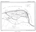 Linden in 1865

References
- ^ a b c "Kerncijfers wijken en buurten 2021". Central Bureau of Statistics. Retrieved 17 April 2022.
- ^ "Postcodetool for 5439NB". Actueel Hoogtebestand Nederland (in Dutch). Het Waterschapshuis. Retrieved 17 April 2022.
- ^ a b c "Linden". Plaatsengids (in Dutch). Retrieved 17 April 2022.
- ^ "Monumentnummer: 8863 Kerkstraat 34 5439 ND te Linden". Dutch Monuments Register (in Dutch). Retrieved 17 April 2022.
- ^ Ad van der Meer and Onno Boonstra, Repertorium van Nederlandse gemeenten, KNAW, 2011.
External links
This North Brabant location article is a stub. You can help Wikipedia by expanding it. |