
Liberty Avenue | ||||||||||||||||||||||||||||||||||||||||||||||||||||||||||||||||||||
|---|---|---|---|---|---|---|---|---|---|---|---|---|---|---|---|---|---|---|---|---|---|---|---|---|---|---|---|---|---|---|---|---|---|---|---|---|---|---|---|---|---|---|---|---|---|---|---|---|---|---|---|---|---|---|---|---|---|---|---|---|---|---|---|---|---|---|---|---|
 View from southbound platform | ||||||||||||||||||||||||||||||||||||||||||||||||||||||||||||||||||||
| Station statistics | ||||||||||||||||||||||||||||||||||||||||||||||||||||||||||||||||||||
| Address | Liberty Avenue & Pennsylvania Avenue Brooklyn, NY 11207 | |||||||||||||||||||||||||||||||||||||||||||||||||||||||||||||||||||
| Borough | Brooklyn | |||||||||||||||||||||||||||||||||||||||||||||||||||||||||||||||||||
| Locale | East New York | |||||||||||||||||||||||||||||||||||||||||||||||||||||||||||||||||||
| Coordinates | 40°40′28″N 73°53′47″W / 40.674357°N 73.896489°W | |||||||||||||||||||||||||||||||||||||||||||||||||||||||||||||||||||
| Division | B (IND)[1] | |||||||||||||||||||||||||||||||||||||||||||||||||||||||||||||||||||
| Line | IND Fulton Street Line | |||||||||||||||||||||||||||||||||||||||||||||||||||||||||||||||||||
| Services | A C | |||||||||||||||||||||||||||||||||||||||||||||||||||||||||||||||||||
| Transit | ||||||||||||||||||||||||||||||||||||||||||||||||||||||||||||||||||||
| Structure | Underground | |||||||||||||||||||||||||||||||||||||||||||||||||||||||||||||||||||
| Platforms | 2 side platforms | |||||||||||||||||||||||||||||||||||||||||||||||||||||||||||||||||||
| Tracks | 4 | |||||||||||||||||||||||||||||||||||||||||||||||||||||||||||||||||||
| Other information | ||||||||||||||||||||||||||||||||||||||||||||||||||||||||||||||||||||
| Opened | November 28, 1948 | |||||||||||||||||||||||||||||||||||||||||||||||||||||||||||||||||||
| Opposite- direction transfer | Yes | |||||||||||||||||||||||||||||||||||||||||||||||||||||||||||||||||||
| Traffic | ||||||||||||||||||||||||||||||||||||||||||||||||||||||||||||||||||||
| 2022 | 465,654[2] | |||||||||||||||||||||||||||||||||||||||||||||||||||||||||||||||||||
| Rank | 390 out of 423[2] | |||||||||||||||||||||||||||||||||||||||||||||||||||||||||||||||||||
| ||||||||||||||||||||||||||||||||||||||||||||||||||||||||||||||||||||
| ||||||||||||||||||||||||||||||||||||||||||||||||||||||||||||||||||||
| ||||||||||||||||||||||||||||||||||||||||||||||||||||||||||||||||||||
| ||||||||||||||||||||||||||||||||||||||||||||||||||||||||||||||||||||
| ||||||||||||||||||||||||||||||||||||||||||||||||||||||||||||||||||||


The Liberty Avenue station is a local station on the IND Fulton Street Line of the New York City Subway, located at the intersection of Liberty and Pennsylvania Avenues in East New York, Brooklyn. It is served by the C train at all times except nights, when the A train takes over service.
Construction on the Liberty Avenue station started in 1938 as part of a four-station extension of the Fulton Street subway along Pitkin Avenue. Work was delayed by funding problems due to World War II, even though the stations were mostly complete. Construction resumed on the extension of the Fulton Street Line in November 1946, and this part of the Fulton Street Line opened in 1948.
History
Planning

Liberty Avenue was part of a four-station extension of the Fulton Street subway along Pitkin Avenue, past its original planned terminus at Broadway Junction.[3][4][5] The Fulton Street subway was the city-owned Independent System (IND)'s main line from Downtown Brooklyn to southern Queens.[3] The line was proposed by the New York City Board of Transportation (BOT) to replace the Brooklyn–Manhattan Transit Corporation's Fulton Street elevated line, which had been in operation since 1888.[6]
The BOT formally announced that it planned to construct a four-track subway under Fulton Street from Lafayette Avenue to Alabama Avenue as part of the IND on March 31, 1927. The BOT's Chief Engineer Robert Ridgeway was directed to investigate possible routes for the line to take from there to the border between Brooklyn and Queens, whether via Atlantic Avenue, Liberty Avenue, or other streets.[7] Ridgeway proposed extending the line via Liberty Avenue to connect with the Fulton Street Elevated at Grant Avenue as part of the IND Second System plan of 1929. The route of the line through East New York was established in May 1930, with the line turning off Fulton Street at Truxton Street, before running via Norman Place and under private property before traveling underneath Liberty Avenue to 80th Street where it would connect to the elevated line.[6]
Further construction past the line's initial terminal at Rockaway Avenue was delayed by funding problems due to the Great Depression in the 1930s. This was temporarily solved by federal Works Progress Administration funding starting in 1936. On July 15, 1937, the BOT submitted a modified plan for the extension of the Fulton Street Line, Route 110-B, to the New York City Board of Estimate.[6] The line would extend from the then-under construction Broadway–East New York station along Pennsylvania Avenue, Pitkin Avenue, Linden Boulevard and Eastern Parkway to 106th Street in southern Queens.[8] This route was formally adopted by the BOT on January 4, 1938, and by the Board of Estimate on January 20, 1938.[9]
On April 22, 1938, the BOT held a public hearing on the proposed terms of the contract to construct Route 110, Section 7, the section of the line along Pennsylvania Avenue between Fulton Street and Bradford Street, which included the Liberty Avenue station.[10] On May 31, 1938, the BOT invited contractors to bid on this section, and on the Route 110, Section 8, which ran along Pitkin Avenue from Bradford Street to Ashford Street.[11] On July 21, 1938, the BOT awarded the contract to construct these two sections to the George H. Flynn Corporation for $5,220,392.[12]
Construction and opening
The portion continuing from east of Rockaway Avenue along Pennsylvania and Pitkin Avenues to Crystal Street, including the Liberty Avenue station, began construction later in 1938.[5] On November 18, 1941, it was announced that construction on the line would likely have to halt and the tunnel would have to be boarded up following the completion of tunneling due to material shortages during World War II, with defense industries getting priority to copper, steel and power equipment. Copper wire would be needed for lighting, signaling and telephones, and steel would be needed for power equipment, signaling and other installations. At the time of the announcement, work was being done to shore up the tunnel walls, to replace the wooden decking covering the open cut with pavement, and finishing the stations.[13]
With the completion of tunneling by December 1942, work halted on the subway extension: the Broadway−East New York station was complete but not in operation due to lack of signal equipment, and the remaining stations to Euclid Avenue were unfinished shells.[6][14][15] At the time, work on the section that included the Liberty Avenue station was more than 99% complete, but vital equipment had yet to be installed, precluding its opening.[16]
Construction resumed on the extension of the Fulton Street Line in November 1946,[17][18] following the conclusion of the war and the allocation of funds obtained by Mayor William O'Dwyer.[19][6] After several test runs, the station opened to the public in the early morning of November 28, 1948, along with the rest of the line to Euclid Avenue.[5][20] The cost of the extension was about $46.5 million.[6][21] Because Liberty Avenue and three other stations were completed later than the rest of the line, they received different design features than other IND stations, including different wall tiles and fluorescent lighting.[6][5][22] It later became the replacement for the elevated BMT Fulton Street Line's Pennsylvania Avenue station, which closed on April 26, 1956 when the connection to the eastern Fulton elevated was opened.[16][23]
Station layout
| Ground | Street level | Exit/entrance |
| Mezzanine | Fare control, station agent, MetroCard machines | |
| Platform level | Side platform | |
| Westbound local | ← ← | |
| Westbound express | ← | |
| Eastbound express | | |
| Eastbound local | | |
| Side platform | ||

This underground station has two side platforms and four tracks.[24] The C train stops here at all times except late nights, while the A serves the station at night and uses the center express tracks to bypass the station during daytime hours.[25][26] The station is between Van Siclen Avenue to the east (railroad south) and Broadway Junction to the west (railroad north).[27] On alternating columns separating the local and express tracks there are signs that read "LIBERTY AVE" in black on white.[28]
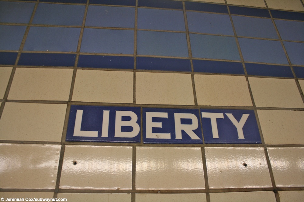
Both platform walls have a periwinkle trim line with a dark periwinkle border and mosaic name tablets reading "LIBERTY AVE." in white sans-serif lettering on a dark periwinkle background and periwinkle border.[29][30] Small tile captions reading "LIBERTY" in white lettering on dark periwinkle run under the trim line, and directional signs in the same style point towards the exit and are present under some of the name tablets.[31][30] The walls have no ads, and there are no columns exempting a few in the recesses where the stairs are. There used to be wide areas under the stairs but they are now used for storage.[28][32]
Exits

The exit is in the center with two stairways from each platform to a mezzanine above the platforms. The exits from the mezzanine lead to all four corners of Liberty and Pennsylvania Avenues.[33][34] The B20 and B83 bus routes stop outside the station.[35]
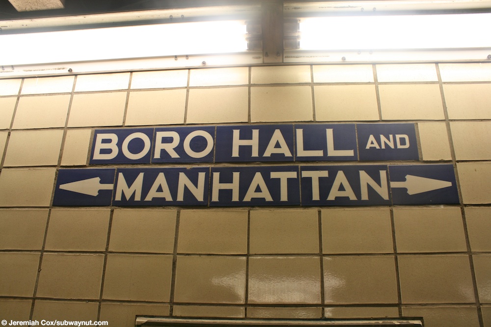
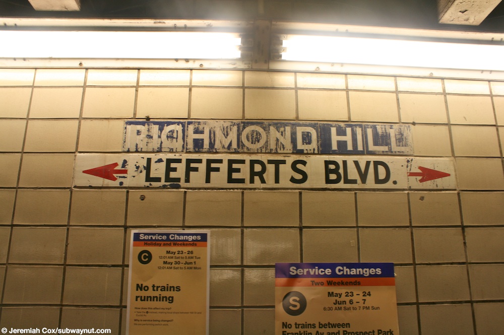
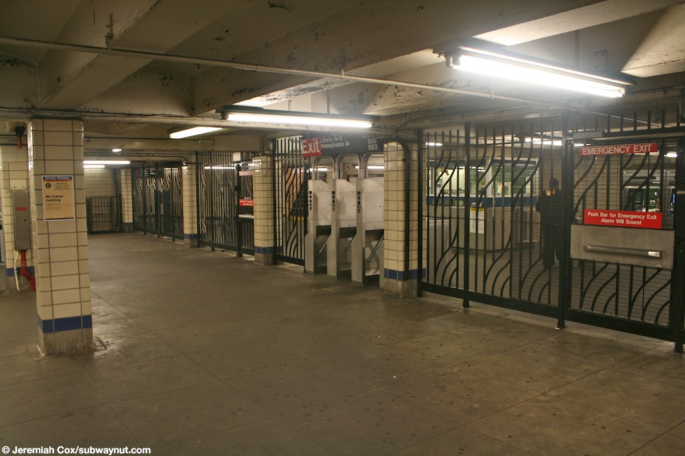
Since the station was completed a decade later than most stations on the Fulton Street Line, the station has a different tiling scheme and the mezzanine is much narrower, and is only above the center of the station. In the mezzanine there are old signs that indicate "TO BORO HALL AND MANHATTAN"[36] and "TO RICHMOND HILL AND LEFFERTS BLVD".[37] There are also alcoves marked with the text "PUBLIC TELEPHONE", as phone booths were originally installed in the station;[18] the alcoves are now empty since the phones have been removed.[38] Free crossovers can be made between directions in the mezzanine. At the southern end of the mezzanine, a fence separates the paid and free areas of the station, with a bank of three turnstiles. The station's token booth is directly opposite the turnstile bank.[39][34]
Ridership
In 2018, the station had 839,241 boardings, making it the 374th most used station in the 423-station system. This amounted to an average of 2,754 passengers per weekday.[2]
References
- ^ "Glossary". Second Avenue Subway Supplemental Draft Environmental Impact Statement (SDEIS) (PDF). Vol. 1. Metropolitan Transportation Authority. March 4, 2003. pp. 1–2. Archived from the original (PDF) on February 26, 2021. Retrieved January 1, 2021.
- ^ a b "Annual Subway Ridership (2017–2022)". Metropolitan Transportation Authority. 2022. Retrieved November 8, 2023.
- ^ a b Duffus, R.L. (September 22, 1929). "Our Great Subway Network Spreads Wider; New Plans of Board of Transportation Involve the Building of More Than One Hundred Miles of Additional Rapid Transit Routes for New York" (PDF). The New York Times. Archived from the original on October 30, 2021. Retrieved August 19, 2015.
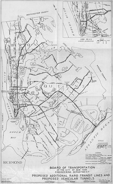
- ^ Proposed Additional Rapid Transit Lines And Proposed Vehicular Tunnel. Board of Transportation of the City of New York Engineering Department. August 23, 1929. Archived from the original on January 22, 2018. Retrieved January 21, 2018.
- ^ a b c d "Trains Roll on $47,000,000 Fulton St. Subway Extension". Brooklyn Daily Eagle. November 29, 1948. p. 2. Archived from the original on October 28, 2016. Retrieved October 9, 2015 – via Newspapers.com
 .
.
- ^ a b c d e f g Raskin, Joseph B. (2013). The Routes Not Taken: A Trip Through New York City's Unbuilt Subway System. New York, New York: Fordham University Press. doi:10.5422/fordham/9780823253692.001.0001. ISBN 978-0-82325-369-2.
- ^ "Fulton Street Subway Route Receives O.K. Approved by Board of Transportation, It Now Goes To Estimate Board". The Brooklyn Citizen. March 31, 1927. Retrieved March 30, 2020 – via Newspapers.com .
- ^ "City Subway Expands". The Brooklyn Daily Eagle. July 11, 1937. Retrieved March 30, 2020 – via Newspapers.com .
- ^ Proceedings. New York City Board of Transportation. 1942. p. 354.
- ^ "Notice of Public Hearing". New York Daily News. April 19, 1938. Archived from the original on November 2, 2022. Retrieved March 30, 2020 – via Newspapers.com .
- ^ Notes - Municipal Reference and Research Center. Municipal Reference and Research Center. 1935. p. 90.
- ^ "Award Contract for 2 Sections Of Fulton Street Subway". The Brooklyn Citizen. July 21, 1938. Retrieved March 30, 2020 – via Newspapers.com .
- ^ "Boro Subway Work Delayed By Priorities: Fulton St. Extension Faces Year's Set-Back Because of Shortage". The Brooklyn Citizen. November 18, 1941. Retrieved March 30, 2020 – via Newspapers.com .
- ^ Blauvelt, Paul (June 9, 1946). "Shortages Snarl $50,000,000 Tube Links". Brooklyn Daily Eagle. p. 21. Archived from the original on October 26, 2016. Retrieved October 9, 2015 – via Newspapers.com .
- ^ "Priorities May Halt Work on Fulton Tube: Vital Defense Materials Are Needed To Complete Spur to Queens County Line". Brooklyn Daily Eagle. November 18, 1941. p. 3. Archived from the original on January 27, 2017. Retrieved August 26, 2016 – via Newspapers.com .
- ^ a b Linder, Bernard (February 2006). "Fulton Street Subway". New York Division Bulletin. 49 (2). Electric Railroader's Association: 2. Archived from the original on September 20, 2016. Retrieved August 27, 2016.
- ^ Jaffe, Alfred (December 6, 1946). "Borough Subway Relief Still 2 or 3 Years Off". Brooklyn Daily Eagle. pp. 1, 5. Archived from the original on October 28, 2016. Retrieved October 9, 2015 – via Newspapers.com .
- ^ a b "Last Word in Subways and Cars for Boro". Brooklyn Daily Eagle. November 23, 1948. p. 8. Archived from the original on October 28, 2016. Retrieved October 9, 2015 – via Newspapers.com .
- ^ Sparberg, Andrew J. (October 2014). From a Nickel to a Token: The Journey from Board of Transportation to MTA. Fordham University Press. ISBN 978-0-8232-6190-1.
- ^ "Fulton Subway Stations Open After All-Night 'Dry Runs'". Brooklyn Daily Eagle. November 28, 1948. Archived from the original on October 28, 2016. Retrieved October 9, 2015 – via Newspapers.com .
- ^ Report for the three and one-half years ending June 30, 1949. New York City Board of Transportation. 1949. hdl:2027/mdp.39015023094926.
- ^ "Last Word in Subways and Cars for Boro". Brooklyn Daily Eagle. November 23, 1948. p. 8. Archived from the original on October 28, 2016. Retrieved October 9, 2015 – via Newspapers.com .
- ^ "First Leg of Rockaways Transit Opened at Cost of $10,154,702" (PDF). The New York Times. April 30, 1956. Archived from the original on July 2, 2022. Retrieved June 29, 2015.
- ^ Dougherty, Peter (2020). Tracks of the New York City Subway 2020 (16th ed.). Dougherty. OCLC 1056711733.
- ^ "A Subway Timetable, Effective June 26, 2022". Metropolitan Transportation Authority. Retrieved August 26, 2023.
- ^ "C Subway Timetable, Effective June 26, 2022". Metropolitan Transportation Authority. Retrieved August 26, 2023.
- ^ "Subway Map" (PDF). Metropolitan Transportation Authority. September 2021. Retrieved September 17, 2021.
- ^ a b Cox, Jeremiah (May 29, 2009). "Looking across the four track subway line at Liberty Avenue, the Euclid Av-bound platform is clearly visible, along with a Liberty Ave sign on a support column". subwaynut.com. Archived from the original on March 7, 2016. Retrieved March 29, 2020.
- ^ Cox, Jeremiah (May 29, 2009). "One the two staircases up to the mezzanine level from the Manhattan-bound platform at Liberty Avenue, notice how modern metal banisters have supplemented the unusual looking original ones". subwaynut.com. Archived from the original on March 7, 2016. Retrieved March 29, 2020.
- ^ a b Cox, Jeremiah (May 29, 2009). "A Liberty Ave name tablet with the directional arrow below it for the next to Liberty Ave". subwaynut.com. Archived from the original on October 20, 2012. Retrieved March 29, 2020.
- ^ Cox, Jeremiah (May 29, 2009). "The Liberty White text on blue-purple tiling beneath the station's trim". subwaynut.com. Archived from the original on March 7, 2016. Retrieved March 29, 2020.
- ^ Cox, Jeremiah (May 29, 2009). "Approaching the center of the Manhattan-bound platform at Liberty Ave, where the area is that has the two narrow staircases up to the mezzanine area and station exit, the platform doubles in width here for the staircases, and there are a couple of tiled station columns". subwaynut.com. Archived from the original on March 8, 2016. Retrieved March 29, 2020.
- ^ "MTA Neighborhood Maps: Liberty Av (C)". mta.info. Metropolitan Transportation Authority. September 2018. Archived from the original on September 29, 2019. Retrieved March 29, 2019.
- ^ a b "East New York Rezoning Proposal Chapter 13: Transportation" (PDF). nyc.gov. New York City Department of City Planning. February 12, 2016. p. 13-49, Figure 13-24a. Archived (PDF) from the original on August 11, 2019. Retrieved March 29, 2020.
- ^ "Brooklyn Bus Map" (PDF). Metropolitan Transportation Authority. October 2020. Retrieved December 1, 2020.
- ^ Cox, Jeremiah (May 29, 2009). "Original tiling at the top of the two platform staircases where they meet on the mezzanine spelling out 'Boro Hall and Manhattan'". subwaynut.com. Archived from the original on March 7, 2016. Retrieved March 29, 2020.
- ^ Cox, Jeremiah (May 29, 2009). "The tiled signs above the two staircases to the Euclid Avenue-bound station are another example of signs for destinations the subway hasn't really reached, the top one is tiled for Richmond Hill, although it looks like all the paint that was ment to say something else has chipped off. The bottom sign is correct but has been painted on over tiles and says Lefferts Blvd". subwaynut.com. Archived from the original on March 7, 2016. Retrieved March 29, 2020.
- ^ Cox, Jeremiah (May 29, 2009). "A tiled sign that says Public Telephones above a small indentation in wall where a phone probably was once upon a time, this sign is currently meaningless". subwaynut.com. Archived from the original on March 7, 2016. Retrieved March 29, 2020.
- ^ Cox, Jeremiah (May 29, 2009). "The adequate but not far too large mezzanine area within fare control at liberty Ave". subwaynut.com. Archived from the original on March 8, 2016. Retrieved March 29, 2020.
External links
- nycsubway.org – IND Fulton Street Line: Liberty Avenue
- Station Reporter — C Train
- The Subway Nut — Liberty Avenue Pictures
- Liberty Avenue entrance from Google Maps Street View
- Platforms from Google Maps Street View
| Fulton St. Line |
|
|---|---|
| |