
| Las Palmas Glacier | |
|---|---|
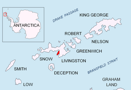 Location of Hurd Peninsula on Livingston Island in the South Shetland Islands | |
 Location of Las Palmas Glacier in Antarctica  Las Palmas Glacier (Antarctica) | |
| Location | Livingston Island South Shetland Islands |
| Coordinates | 62°41′00″S 60°25′00″W / 62.68333°S 60.41667°W |
| Thickness | unknown |
| Terminus | Las Palmas Cove |
| Status | unknown |

Las Palmas Glacier (62°41′S 60°25′W / 62.683°S 60.417°W) is a glacier flowing west-northwest from Hurd Dome and terminating at Las Palmas Cove, South Bay, Livingston Island, Antarctica. The name was given by the Spanish Antarctic Expedition, about 1991, after the ship Las Palmas of the Spanish Antarctic campaigns since 1988.[1]
YouTube Encyclopedic
-
1/3Views:89180710 560
-
Panorama on a very impressive glacier. Biafo Glacier, Snow Lake.
-
Cruise ships "Rotterdam" and "Queen Elizabeth" ⚓ in Las Palmas de Gran Canaria on December 28, 2015
-
ICELAND IS AMAZING! One Day in Iceland: The Golden Circle Tour
Transcription
See also
Maps
- Isla Livingston: Península Hurd. Mapa topográfico de escala 1:25000. Madrid: Servicio Geográfico del Ejército, 1991. (Map reproduced on p. 16 of the linked work)
- L.L. Ivanov et al. Antarctica: Livingston Island and Greenwich Island, South Shetland Islands. Scale 1:100000 topographic map. Sofia: Antarctic Place-names Commission of Bulgaria, 2005.
- L.L. Ivanov. Antarctica: Livingston Island and Greenwich, Robert, Snow and Smith Islands. Scale 1:120000 topographic map. Troyan: Manfred Wörner Foundation, 2009. ISBN 978-954-92032-6-4
- Antarctic Digital Database (ADD). Scale 1:250000 topographic map of Antarctica. Scientific Committee on Antarctic Research (SCAR). Since 1993, regularly upgraded and updated.
- L.L. Ivanov. Antarctica: Livingston Island and Smith Island. Scale 1:100000 topographic map. Manfred Wörner Foundation, 2017. ISBN 978-619-90008-3-0
References
 This article incorporates public domain material from "Las Palmas Glacier". Geographic Names Information System. United States Geological Survey.
External links
This article about a glacier in Livingston Island is a stub. You can help Wikipedia by expanding it. |